| I T | Map Via Francigena | From San Gimignano to Monteriggioni
|
The Via Francigena | From San Gimignano to Monteriggioni |
'The Via Francigena is an ancient road between Rome and Canterbury, passing through England, France, Switzerland and Italy. In mediaeval times it was an important road and pilgrimage route. To pilgrims headed south, it was the Via Romea; to those headed north, the Via Francigena. Walking in Tuscany | The Via Francigena in the Siena Region |
|||
 |
|||
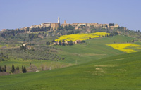
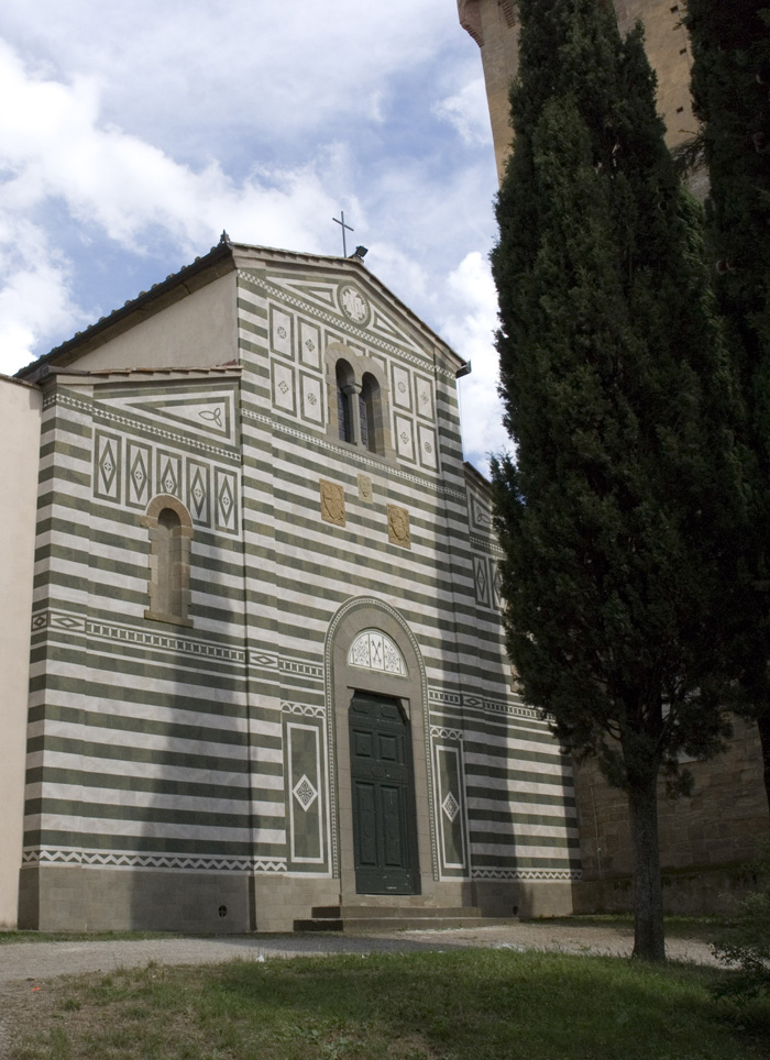
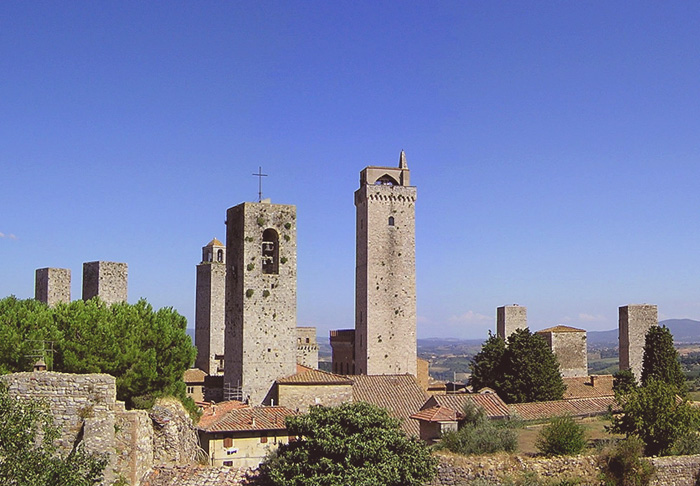
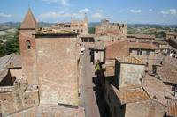
San Gimignano |
|||
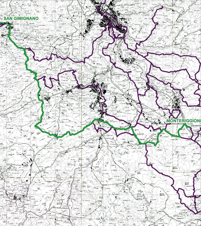
| 10 | From San Gimignano to Monteriggioni - 29,8 km |
||
Total length (km): 29.8 Travel time on foot (h: min): 7.30 Paved roads: 19% Dirt roads and driveways: 70% Mule tracks and trails: 12% Getting to the starting point: FS Empoli-Siena Railway Line, Poggibonsi station; bus line 133 for S. Gimignano |
|||
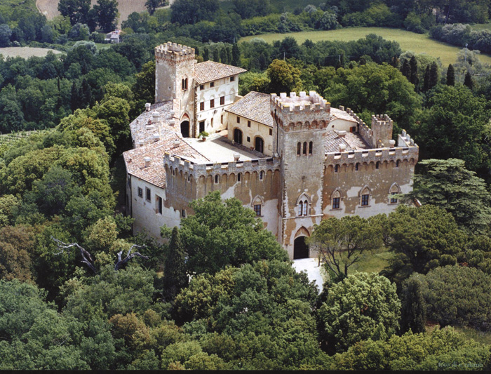
This 29.8 km leg begins in San Gimignano and takes in about 7 hours to complete. It is one of the most beautiful legs of the Via Francigena, and after the frst section of the path, you begin to walk up and down in the valley of the Foci river, near Molino d'Aiano. A path leads upward to the Romanesque church of Santa Maria a Coneo. Then you cross the bridge on the hilltop to reach the Romanesque church of San Martino di Strove. Then you go to the Abbey of Island, before catching a sight of Monteriggioni, with its unmistakable ring of walls and towers that dominate the surrounding hills. |
|||
Map| La Via Francigena | From San Gimignano to Monteriggioni |
|||
 |
|||
Scarica in pdf le mappe 1:10.000 della Tappa 10 | www.francigena.provincia.siena.it/percorsi/tappa-10 |
|||
| La via Francigena | From Quartaia to Strove |
|||
|
|||
| San Gimignano |
|||
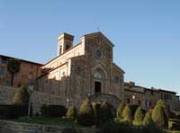
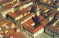
| San Gimignano is mainly famous for its medieval architecture, especially its towers, which may be seen from several kilometres outside the town. The town also is known for the white wine, Vernaccia di San Gimignano, produced from the Vernaccia grape which is grown in the area. While in other cities, such as Bologna or Florence, most or all of their towers have been brought down due to wars, catastrophes, or urban renewal, San Gimignano has managed to conserve fourteen towers of varying height which have become its international symbol. There are many churches in the town: the two main ones are the Collegiata, formerly a cathedral, and Sant'Agostino, housing a wide representation of artworks from some of the main Italian renaissance artists. The heart of the town contains the four squares, the Piazza della Cisterna, the Piazza Duomo where the Collegiata is located, the Piazza Pecori and the Piazza delle Erbe. The main streets are Via San Matteo and Via San Giovanni, which cross the city from north to south. |
|||
| The Communal Palace, once seat of the podestà, is currently home of the town gallery, with works by Pinturicchio, Benozzo Gozzoli, Filippino Lippi, Domenico di Michelino, Pier Francesco Fiorentino and others. From Dante's Hall in the palace, access may be made to a Majesty fresco by Lippo Memmi, as well as the Torre del Podestà or Torre Grossa, 1311, which stands fifty-four metres high. The palazzo dates from the late 13th century, and was built on the ruins of an existing building between 1289 and 1298.[1] Further expanded in the 14th century, the facade is characterised by arched windows, with the lower half of the frontage built with stone, and the upper part in brick. On the ground floor is a courtyard, which was built in 1323 and is decorated with the coats of arms of those who have held public office in the municipality. The main civic offices of the town council are now located on this ground floor. On the first floor is a stepped gallery from which dignitaries would address the gathered crowd in the square. The battlements date from a restoration of the nineteenth century, and the structure is capped by the "Torre Grossa” (great tower). This tower was completed in 1300 and (at 54 meters) is the highest tower in the walled town. The upper stories of the palazzo house the Sala del Consiglio, and (since 1852) the civic museum and gallery. The "Sala del Consiglio" is a large reception hall which was used as the council chamber. It is commonly known as the "Sala di Dante" and is named for the noted poet Dante Alighieri who visited San Gimignano in 1300 as an ambassador of the Florentine Republic. The room is decorated with a Maestà by Lippo Memmi. Commissioned in 1317 by Nello de Mino Tolomei (then podestà of San Gimignano), the fresco is believed to have been inspired by Simone Martini's Maestà from the Palazzo Pubblico in Siena. The fresco shows Mary seated on a throne surrounded by adoring saints and angels (including patron Nello de Mino Tolomei). The gallery itself is on the second floor and contains works by Coppo di Marcovaldo, Lippo Memmi, Benozzo Gozzoli, Filippino Lippi, Il Sodoma and Pinturicchio. The first room is called "The Trinity", from the work it contains by Pier Francesco Fiorentino dated to 1497. It also houses a "Madonna and Child with Saints" by Leonardo da Pistoia and a "Pietà" by Bastiano Mainardi. Other rooms contain a Maestà from the late thirteenth century, altar decorations by Memmo di Filippuccio, a "Madonna and Child" by Vincenzo Tamagni (1528), several Gothic altarpieces (including one showing scenes from the life of Saint Gimignano), a "Madonna with Saints Gregory and Benedict" by Pinturicchio, and two medieval crucifixes of the Florentine school. The Podestà apartments (Camera del Podestà) are frescoed with matrimonial scenes of a couple taking a bath and going to bed. (An unusual work by Memmo di Filippuccio dated to the early fourteenth century.) The Duomo, or Chiesa Collegiate, is the main church of San Gimignano, situated in the Piazza del Duomo at the town's heart. It was once the Duomo (cathedral), but since San Gimignano no longer has a bishop it has reverted to the status of a collegiate church. |
|||
 |
|||
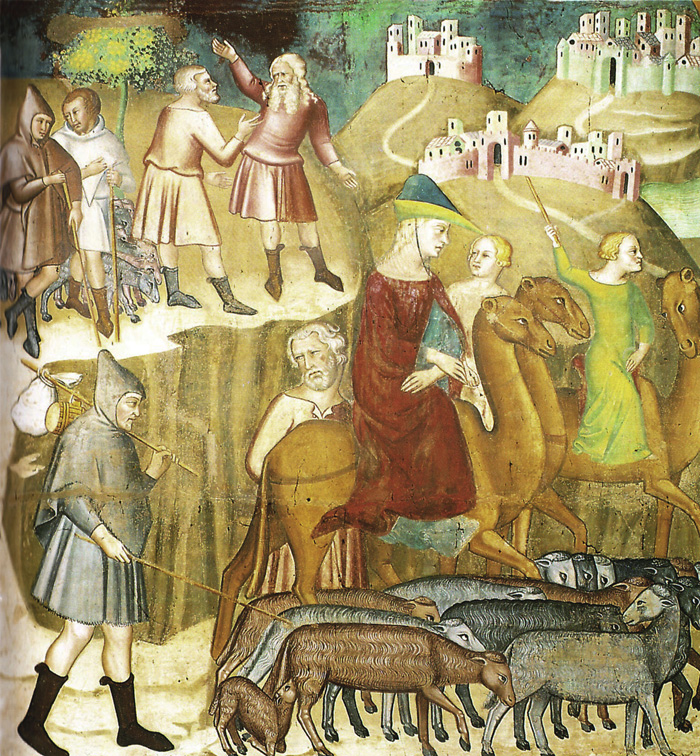
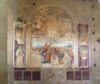
Bartolo di Fredi, Abramo si divide da Lot nella terra di Canaan, affresco, (Duomo, San Gimignano) |
|||
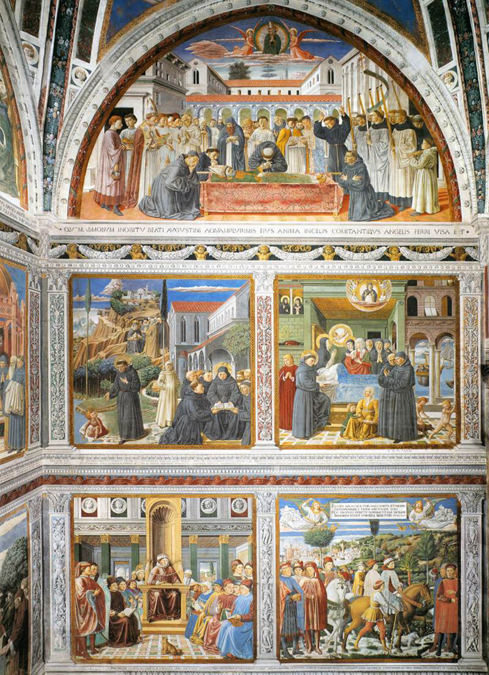
Bartolo di Fredi (c. 1330 – January 26, 1410), sometimes called Bartolo Battiloro, was an Italian painter, born in Siena, classified as a member of the Sienese School. He had a large studio and was one of the most influential painters working in Siena and the surrounding towns in the second half of the fourteenth century. He registered in the Guild of that city in 1355; he had several children, who all died before him, with the exception of Andrea di Bartolo. He was the companion of Andrea Vanni from 1353, and helped decorate the Hall of Council at Siena, in 1361. From 1356 he worked in the Collegiata, or principal church, of San Gimignano, some 30 km from Siena, where he painted the entire side of the left aisle with a cycle of frescoes of scenes from the Old Testament; the completed work was signed and dated in 1367. In 1366 the Council of the city of Gimignano ordered a painting, representing Two Monks of the Augustine Order to be placed in the Palazzo Pubblico, in order to commemorate the settlement of some disputes which had long existed between that order and the city. In the early part of 1367 he was employed in Siena with Giacomo di Mino in the decorations of the cathedral. In 1372 he rose to a position in the government of the city, and was sent to welcome the new Podestà on his approach to Siena. In 1381 he was himself made a member of the Council, and in 1382 he executed the Descent from the Cross now in the Sacristy of San Francesco, Montalcino. The same church also possesses panels painted by him containing the Baptism of Christ figures of SS. Peter, Paul, and Francis, and five scenes from the life of St. Philip of Montalcino. In 1389, Bartolo, assisted by Luca Thome, painted the altar-piece for the Shoemakers' Company, in the Cathedral, and continued from that year until his death to furnish altar-pieces for the cathedral and other churches of Siena, which have now all disappeared. His style is marked by the rejection of the concrete figures associated with Pietro Lorenzetti to instead favor flatter decorative otherworldly compositions in the manner of Simone Martini and Duccio. He combined a spirit of fantasy with anecdotal details. Piazza Sant'Agostino is another peaceful oasis in San Gimignano. It is enclosed by rows of houses with a central cistern and is dominated by two large churches. The first, San Pietro, is reached through the Porta San Matteo. It was founded in the 11th century and is Romanesque with a little bell tower. The other, Sant'Agostino, is set against the background of the piazza and looks out over it from atop a stairway. The Chiesa di Sant'Agostino is an imposing 13th century building. The chiesa di Sant'Agostino (Church of St Augustine) is the second largest church in San Gimignano, after the Collegiata. It can be reached from the Porta St. Matteo by passing along via Cellolese. Its very simple façade still retains the characteristics of its original architectural style. The door in the main façade is not used as the entrance, instead in order to enter the Church the door on the right hand side is generally used. The interior is a large hall dominated by the seventeen-panel fresco cycle on The Life of St Augustine around the high altar, painted by Benozzo Gozzoli between 1463 and 1467. Benozzo Gozzoli, in collaboration with several assistants, produced here his main work, the decorations of the apsidal chapel of the church in 1464-65. As in Montefalco, the life of St Augustine is narrated as an ascent: the lowest register depicts the education, teachings and travels, the middle one his path to faith, and the lunettes the culmination of his journey through life. The vault symbolizes his ascent to heaven. The lavish framing of the picture fields by means of narrow gold borders and painted pilasters is an innovation in this form. The cycle depicts 17 scenes from the life of St Augustine. The pictures, which are arranged in three rows, use the traditional horizontal direction of reading, from the bottom left to the top right. The vaulting shows the four Evangelists on concentrically painted clouds, creating the impression of a circular vault.[3] Benozzo was given the commission by Fra Domenico Strambi, a learned Augustinian monk belonging to the monastery who in 1449 had been given a grant by the town to study theology at the Sorbonne in Paris. The paintings were produced within the contemporary context of the reformation of the monastery of Sant'Agostino. The intention was to merge it with the Augustinian order of San Salvatore in Lecceto near Siena. The choir, being the place where the community of monks assembled, was decorated with a didactic program of the life and work of St Augustine. The cycle of St Augustine is one of the main works of Tuscan narrative art dating from the middle of the century. It can take its place alongside the fresco cycle of the Legend of the True Cross (1453/54) by Piero della Francesca in Arezzo and Donatello's Passion Pulpit and Resurrection Pulpit (1460-62) in San Lorenzo in Florence. The cycle depicts 17 scenes from the life of the Father of the Church. When selecting the scenes from the legend of St Augustine, Benozzo had to create his own iconography without using models, and Domenico Strambi helped him to achieve this. The distinguishing feature of the pictorial program is a simple construction of scenes which shows the protagonists in realistic rural, urban or architectural surroundings. Other notable works of art in this church are the fragments remaining from a fresco by Bartolo di Fredi and a fresco showing "The Madonna" painted by Lippo Memmi in 1317 as well as the tablet representing "The Madonna and the Saints" painted by Fra Bartolomeo in 1530 and, in the sacristy, a wooden Crucifix dating from the 15th century. Benozzo Gozzoli | Fresco cycle in the apsidal chapel of Sant'Agostino, San Gimignano Sant'Agostino |
|
||
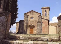
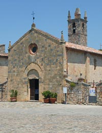
| Santi Ippolito e Cassiano a Coneo |
|||
| The Parish Church of Santi Ippolito e Cassiano in Coneo is reached by a small road set beyond Campiglia dei Foci, on the road that goes from Colle Val d`Elsa towards Volterra. The country church of Santi Ippolito e Cassinao existed as far back as the 10th century, and was later part of the bishopric of Volterra. Ttowards the end of the 12th century it came into the sphere of political influence of the municipality of Colle. From that time on, it did not flourish particularly, possibly due to a descrease in the local population. Whatever the explanation, as early as 1413 it was found to be largely in ruinsThe original layout had three naves and three apses. Today only the central and the left naves remain. The upper part of the faqade is covered by a lively red and white bi-colored faqade, typical of the Siena-Volterra area, with a type of masonry that alternates one stone rank with two brick ones, according to a type that is also found, in the Montesiepi Hermitage, not far from Coneo. The remains of a blind loggia with a double-lancet window are on the upper part of the faqade, anda circular opening corresponds to the bell tower. The completely bare interior has a variety of pillars and richly decorated capitals. |
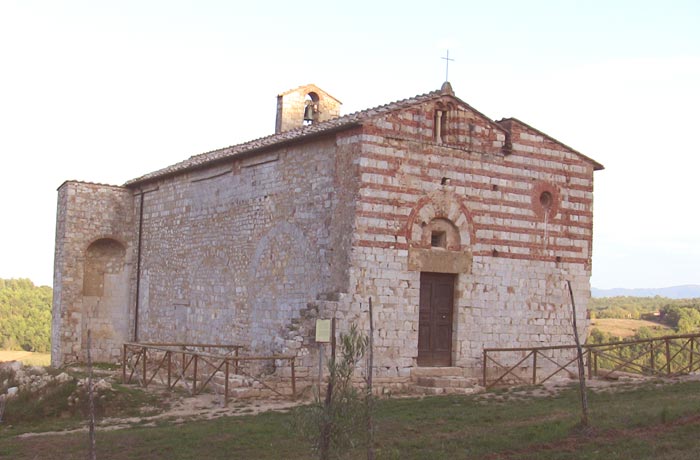 Pieve di Santi Ippolito e Cassiano a Coneo |
||
| Santa Maria a Coneo |
|||
| Abbazia di Conéo, Badia a Coneo near Campiglia, is a Romanesque structure that was founded by the Vallombrosan monks at the start of the 12 C and is one of the most interesting examples of religious architecture near Colle Val d'Elsa. Its plan is in the shape of the Latin cross, as is typical of Vallombrosan churches, and the intersection of the nave and the transept is surmounted by a sectioned dome, which is octagonal inside. The internal capitals and the cornice which runs round the outside of the building are decorated with starred flowers and other geometrical devices, of great artistic beauty. The building possesses a number of pre-Romanesque features, with numerous external brackets in the shape of imaginary animals. Here one can join the historic Via Francigena. The Abbazia di Conéo is reached by a small road set beyond Campiglia dei Foci, on the road that goes from Colle Val d`Elsa towards Volterra. At Le Grazie, opposite the sanctuary, turn down the provincial road for Casole d'Elsa, following it for around 1 km, as far as the turn-off on the right for Conéo and the Abbey of the same name. Take the narrow, surfaced road and cross open, rolling countryside, which was once heavily wooded (from which derives the place-name Bosco di Conéo or Coneo Forest, which is not dissimilar to Boscona, another place not far away). We then reach a bifurcation and, if we turn to the left, we arrive at Conéo. Instead, continuing on to the right, we descend through woods of common oak and Turkey oak as far as the small road to the left for the nearby Abbey of Conéo. Smal churches in Tuscany | The Abbey of Santa Maria Assunta in Conèo (Badia a Conèo) |
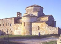 Abbazia di Conéo |
||
| Quartaia |
|||
| Fabbrica |
|||
| San Niccolò a Lano | |||
| Mensanello | |||
Tenuta Di Mensanello is a characteristic Tuscan farmhouse set in the countryside between Siena and San Gimignano. |
|||
| Villa Sabolini |
|||
|
|||
| Lano |
|||
| Pieve di Santa Maria a Castello |
|||
| Established at the start of the 11th century but probably with much older origins, the ancient country church is now used for civic purposes. The old church, currently without its left nave, is a rare example of a religious building proceeding the Romanesque period. Another peculiarity of the complex is a small building with a central design located to the side of the church and of the same era. It is an ancient baptistery and was a fairly unusual building for rural churches in medieval Tuscany. |
|||
| Calcinaia |
|||
| Bagni delle Caldane |
|||
| The Caldane are ancient thermal baths near Colle Val d'Elsa with warm water springs that have therapeutic properties known since Etruscan and Roman times, as witnessed by the enormous number of coins found on site. The water is extraordinarily clear and rich in minerals, it was known to bring a remedy for various ailments including rashes and was used a lot thanks to its positioning on the "via Francigena" that passed right by Gracciano. |
|||
| Sant'Andrea a Scarna |
|||
| Strove |
|||
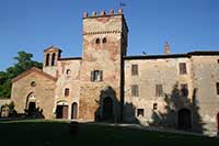
| Abbadia a Isola |
|||
Abbadia a Isola is located on the road that connect Monteriggioni and Strove, on the edge of an extensive plain below the wooded slopes of Mount Maggio,/
|
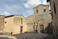 Abbadia Isola
|
||
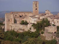
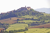
| Monteriggioni |
|||
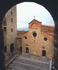
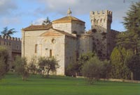
| Half way between San Gimignano and Pienza, on a hill that overlooks the Via Cassia-Francigena, is Monteriggioni, a magnificent fortified town that has retained its circle of walls almost completely intact. The interior of Monteriggioni is made up of a large square, Piazza Roma, onto which faces the Church of Santa Maria Assunta, built around a single vaulted nave that terminates in a square apse. The coloured facade has a doorway surmounted by an archivolt. The bell tower was added in the 18th century. The beautiful medieval walled town of Monteriggioni is among one of the best preserved in all of Italy. Every year it not only attracts tourists but also medieval archaeologists and historians, as well as architects. The approximately circular walls, nearly 570 metres long, follow the natural contour of the hill and were built between 1213 and 1219. They are interrupted by two gates, Porta Fiorentina, facing Florence to the North, Porta Romana, opening towards Rome to the South, and 14 towers. A main street connects the two gates in a roughly straight line. Entering through Porta Roma, originally provided with a heavy gate that was lowered in case of danger, one arrives in Piazza Roma, the main square and heart of the village which is dominated by the Romanesque church of Santa Maria Assunta. To date, the square is surrounded by gardens and orchards, which in the past were very important for the survival of the population in case of siege. In the local museum there is a collection of medieval and Renaissance arms and armours, faithful reproductions, of which some can be touched, handled, weighed and even worn. Furthermore, it is also possible to walk along two sections of the ancient battlements, from which one can enjoy wonderful views over Chianti and Montagnola Senese. The town was originally built by the Republic of Siena for a defensive purpose since the position dominated and watched over the Via Francigena in the direction of Florence, historic rival of Siena. The Via Francigena, ancient road between Rome and Canterbury, was very important during the Middle Ages for merchant and travellers, as well as being the major pilgrimage route. In the stretch between San Gimignano and Siena, the Via Francigena crosses the territory of Monteriggioni, where one of the oldest stopping stations still exists today: the abbey of Abbadia Isola. |
 Chiesa di Santa Maria Assunta Chiesa di Santa Maria Assunta |
||
 |
|||
Monteriggioni |
|||
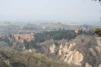
| South of Monteriggioni | Eremo di S. Leonardo al Lago |
|||
| Recorded at the end of the 13th century, the hermitage stands on the margins of what was called, in the medieval period, the lake of Verano. The lake was situated south of Monteriggioni but is no longer in existence. When it became part of the congregation of the Hermit Brothers of St. Augustine in 1243, S. Leonardo it was aggregated to the nearby hermitage of Lecceto a few years later where it remained until 1516. At the start of the fourteenth century, the Blessed Agostino Novello, an important religious figure who had taken up residence during the last years of his life, died here. A noteworthy element of the architectural complex is the beautiful church with a single nave built entirely in stone, excellently conserving the simplicity of its medieval lines. Inside, the small square apse is decorated by a cycle of 14th century frescos by the Siena born painter Lippo Vanni. To the side of the church, as well as the remains of a defensive wall with turrets, there are cloisters and a part of the monks' dwellings, amongst which should be highlighted the refectory frescoed by Giovanni di Paolo in the 15th century. Not far from the hermitage of S. Leonardo stands the so-called Pyramid, an obelisk to the memory of the eighteenth century draining of the area below, which is still known today as the Pian del Lago (the Lake Plain). The Pyramid also signals the start of the Grand Duke's canal, a tunnel of around two kilometres long which served to permit the running off of the waters and which is perfectly preserved and still usable today.
|
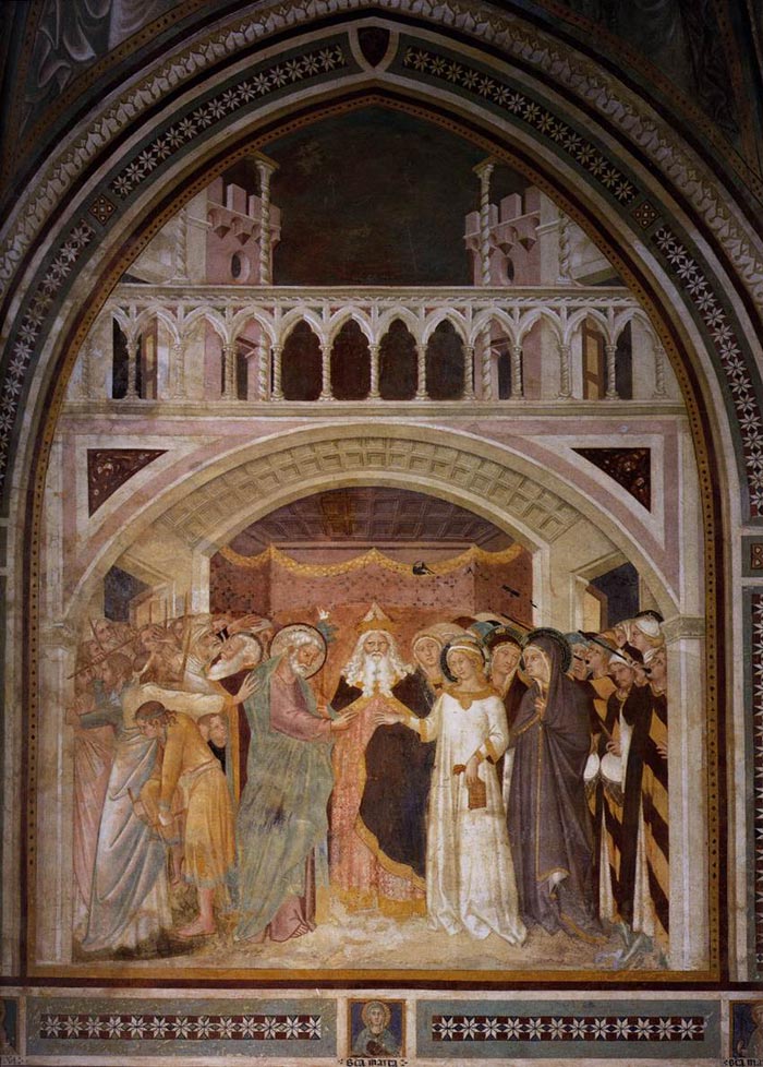 The Betrothal of the Virgin, 1360s, fresco, San Leonardo al Lago, Siena The Betrothal of the Virgin, 1360s, fresco, San Leonardo al Lago, Siena |
||
|
|||
Via Francigena | Da Gambassi Terme a San Gimignano Survey Source Associazione Nazionale delle Vie Francigene; Alessandra Angeloni (a cura di), "Via Francigena. Guida del percorso da Castelfiorentino alle porte di Siena", Betti Editrice, 2010, Siena. (en) |
|||


| The Via Francigena | Walk Route |
|||
| Via Francigena – Walk Route The road books, the maps, the Google Earth and the GPS trails for the walk route of the Via Francigena. A practical and utile guidebook for the numerous Europeans who choose to experience Europe following the route and discovering the paths that make up the historical stages. The Via Francigena itinerary is completely traced by GPS and fully described on maps and road books. All the materials are available on www.francigenalibrari.beniculturali.it/news1_en.html |
|||
| (See the complete Route on Google Earth) |
|||
| The Via Francigena | Links |
|||
| Reasoned list of useful cultural and tourist links on the ancient faith ways.The Via Francigena web sites
|
|||
La Via Francigena, visualizza la mappa
Comune Gambassi Terme | http://www.comune.gambassi-terme.fi.it/ |
|||
| Guides |
|||
| Trezzini, La Via Francigena. Vademecum dal Gran San Bernardo a Roma (Association Via Francigena) 2000 |
|||
Paul Chinn and Babette Gallard, The Lightfoot Guide to the Via Francigena, Pilgrimage Publications, 2009. In 3 volumes, Canterbury to Besançon; Besançon to Vercelli; and Vercelli to Rome. Available through our Bookshop. Mainly inteneded for cyclists, but it gives good route-finding information with GPS references and details of accommodation and services. |
|||
Guida alla Via Francigena: 900 chilometri a piedi sulle strade del pellegrinaggio verso Roma, by Monica d'Atti and Franco Cinti. (Supplemento al numero 132, aprile 2006, di "Terra di Mezzo." Piazza Napoli 30/6, 20146 Milano.) ISBN: 88-8938-565-0. |
|||
| Maps |
|||
| Monica D’Atti & Franco Cinti, La Via Francigena. Cartografia e GPS. Dal Monginevro a Roma lungo l’itinerario storico, Milan: Terre di Mezzo Editore, 2007. ISBN: 978-88-8985-60-9 |
|||
| TOPOFRANCIGENA A.Canterbury-Gd St-Bernard 1000km: 40 geo-cultural pocket-sized colour map-cards 150g prepared by Adelaide Trezzini with Giovanni Caselli providing the graphics View TOPOFRANCIGENA dal Gran San Bernardo a Roma (900km) was published in 2005. The Topofrancigena is a set of maps (again in two parts Canterbury to St Bernard Pass published - Italian 2005) of the route. The Canterbury to St Bernard Pass section consists of 40 pages in full colour, with alternative routes, very loosely bound so old pages can be discarded. The maps show town or villages with accommodation and churches and historic sights. |
|||
Walking Pilgrim, old pilgrim routes in W Europe | Via Francigena in Italy WMS/APIs for Maps: Italy | Portale Cartografico Nazionale; includes 1:250,000, 1:100,000 and 1:25,000 topo maps (beware! many of the sheets are very old) |
|||
[0] Source: Bibliography |
|||
|
||||
 |
 |
 |
||
Podere Santa Pia, garden |
Podere Santa Pia |
Abbadia d’Ombrone and Monastero d’Ombrone near Castelnuovo Berardenga. |
||
 |
 |
|||
Badia di Sicille, Trequanda |
Colle di Val d'Elsa |
Pienza |
||
 |
 |
 |
||
Abbazia di Monte Oliveto Maggiore |
Sansepolcro |
Certaldo
|
||
| The Val d'Elsa | ||||
| The Val d’Elsa lies between the provinces of Florence and Siena. Divided by the river Elsa, this area of Tuscany is one of the region’s most beautiful sections of countryside, rich in vineyards and olive groves that produce wine and oil renowned throughout the world. Hardly, in another part of Italy, history is present as in Val d'Elsa: not only for the architecture that resists intact in at least three conspicuous places: San Gimignano, Monteriggioni and Colle di Val d'Elsa. The strategic importance of the Val d'Elsa lies in its paths and roads. It is both the passageway to the sea and a sacred path. Its development was due to the Via Francigena and its propensity towards a sustainable economy is thanks to its wine and olive oil production, as well as crystal, mechanics, paper, electronics, ceramic and furniture production. |
||||
| Barberino Val d'Elsa |
||||
Barberino Val d’Elsa, situated high up above the valley from which it takes its name and halfway between Florence and Siena, on the north-western borders of the Chianti area. The town is still characterised by a historic medieval centre set out in an oblong or shaft-shaped form. The Casole area was originally inhabited by the Etruscans. The first written evidence of the town dates back to 896 when Adaberto, a Tuscan marquis, conceded the town to the Bishop of Volterra. The diocese of Volterra ruled over the town for a long time, as confirmed in an 1186 document in which the emperor Enrico VI renewed the concession to the Bishop. At the start of the thirteenth century, Casole gained its independence and became a free town able to elect its own town council. For many years the territory was fought over by Sienese, Florentine and Volterran forces. In 1259 the town was occupied by the Florentine army but following the battle at Montaperti and the Castelfiorentino treaty of 1260, it was definitively brought under Sienese rule. The town’s defensive walls were built by the Sienese during this period. The fortress and the defensive walls are still visible today, although the town gates have unfortunately been destroyed. The southern gate was destroyed by German mines during the Second World War. Main attractions are the church of Santo Spirito and Palazzo Pretorio (the ancient seat of the town council) which is decorated with the terracotta family crests of the town’s various mayors over the centuries. Also of interest are the Palazzo Casolani-Berlingheri-Scheggi, the Collegiata of Santa Maria Assunta and the church of San Pietro and San Niccolò. The Collegiata is home to an important fourteenth century funerary monument belonging to Bishop Tommaso d’Andrea. This sculpture is the first example of its kind of a similar sculpture resting on a ‘shelf’ and belongs to afourteenth century Tuscan school of sculpture. |
|
|||
 Casole d’Elsa |
||||
Castelfiorentino |
||||
| Castelfiorentino is situated in an optimous position on the Chianti hills, in the heart of Tuscany. Far back in 1149 the name of Castelfiorentino was given to a castle erected along Via Francigena, on the site where the Roman settlement of Timignano once stood. Enclosed within the fortified castle, set upon a hilltop, was the parish church of Sant' Ippolito (the ancient parish of San Biagio); erected within a second ring of the walls were Borgo d'Elsa and Borgo Nuovo. Frazioni: Cambiano, Castelnuovo d'Elsa, Coiano, Dogana, Fontanella, Granaiolo, Petrazzi |
|
|||
| Certaldo |
||||
Like many other Tuscan towns. Certaldo is divided between its medieval walled town on a hill and the modern residential and industrial suburb spread out below. |
« Certaldo, come voi forse avete potuto udire, è un castello di Val d'Elsa posto nel nostro contado, il quale, quantunque picciol sia, già di nobil uomini e d'agiati fu abitato »
|
|||
| Colle di Val d'Elsa - Dometaia Archeological Park - Etruscan traces along the Via Francigena |
||||
Colle Val d’Elsa is a town on three levels: Borgo, which is accessible through the majestic Porta Nuova and is made up of beautiful 16th and 17th century patrician town houses; Castello, or Colle Alta, which still retains its original Medieval appearance and is the town’s religious and political centre; and Piano, or Colle Bassa, which is composed of the ancient hamlet of Spugna, where the town’s wool weavers, paper manufacturers and glass craftsmen made use of the nearby river Elsa. In 1592 Colle Val d’Elsa was made a bishopric. |
|
|||
| Gambassi Terme |
||||
| Gambassi Terme is located about 35 km southwest of Florence. Main sights are the church of San Giovanni Battista, in the frazione of Varna, which houses a replica of Andrea del Sarto's Madonna with Child and Saints, the Romanesque Pieve of Santa Maria Assunta (12th century), and the Parco Comunale, former garden of the Villa Sinnai. The Gambassi garden is located between the historical centre and the facility of the Terme di Gambassi (Gambassi Hot Springs). In the past the park shaped the expansive garden of the Villa Sinnai, and still testifies to its elegance and richness. In 1916 the villa was acquired by the Piccoli family, which introduced some exotic plants imported from Africa into the park. Just outside the centre of Gambassi on the road towards Castelfiorentino stands the splendid Romanesque parish church of Santa Maria a Chianni, one of the most significant monuments of Romanesque architecture in the Elsa Valley. The first mention of the parish of Santa Maria a Chianni can be found in a document dated 26 March 988. The basilica design with a nave and two side aisles is grafted on a wide, protruding transept, on the end wall of which there were originally five semi-circular apses. Of particular interest are the four smaller apses made in the depth of the end wall itself, following a design which is also found in the Cathedral of Volterra. Frazioni: Pillo, Borgoforte, Varna, Catignano, Casenuove, Castagno, Badia a Elmi |
 Pieve di Santa Maria Assunta in Chianni |
|||
| Montaione | ||||
| According to some archaeological finds dated back at Etruscan-Roman epochs, the charming village of Montaione has been inhabited from very ancient times. At a few metres from the old town centre you can indeed admire remains of a Roman cistern dated at the II century A.C., as well as some finds of Etruscan china in the area of Santo Stefano. Even the Church of San Biagio, at 500 metres from the village, shows that Montaione was already inhabited in early Christian times, even though some more detailed news about it started from the Middle Ages. In 1118 at a distance of 2 Km from the centre of the town, it was built the “Pieve di San Regolo”: notable example of Romanesque architecture in Tuscany, which nevertheless not correspond to the historical church nowadays located at the very centre of Montaione. Once become commune in 1257, Montaione was involved in the battles among Gimignano, Volterra and San Miniato: battles that deeply marked the Middle Ages in Tuscany. During that period, the Castle of Montaione was ringed by sturdy walls and framed by 11 imposing towers. The urban district, crossed lengthwise by three streets (like every typical Roman camp), enclosed the Church of San Bartolomeo (today dedicated to San Regolo) and Palazzo Pretorio. Montaione is provided with a rich network of trekking paths. The routes are organized along 6 itineraries, planned in order to discover the countryside, exploiting the different areas, woods and slopes. Frazioni: Casetta, Sant'Antonio, Olmo, Filicaja, Le Mura, Gli Alberi, La Sughera, Santo Stefano, Iano, San Vivaldo, Castelfalfi, Barbialla, Collegalli, Tonda, Piaggia, Vignale |
 |
|||
| Montelupo Fiorentino | ||||
| Montelupo Fiorentino is the centre of the production of Florentine majolica. The territory of Montelupo Fiorentino was inhabited from time immemorial thanks to its fruitfulness, to the abundance of water and to its strategic geographical position (a natural crossroads on the communication route between the Apennines and southern Tuscany). Montelupo was probably founded at the end of the Early Middle Ages with the construction of a castle. Towards the end of the 14th century AD, Montelupo Fiorentino (who never had the name of Malborghetto, a real romantic invention) became a "walled village" of the Florentine countryside. The walls were built in 1348 (the year of the Black Death), and the Statute of the Powers dates back to 1414. Until the 16th century AD, Montelupo Fiorentino lived his golden age. In mid 17th century AD, due to the plague that hit the area hard, a period of decline began, and irreversibly Montelupo Fiorentino was led to a drastic restructuring, which reached its peak in the late 18th century AD. Since then and until World War II, Montelupo Fiorentino found himself on the border of everything. The country was shaken in the last half of the 20th century AD by some catastrophic natural events in nature. Most important are the floods of 1949,1966 and 1992. In these three events in fact, the Arno River north of Montelupo Fiorentino, and the Pesa River adjacent, flood submerging the country below four meters of water (two meters in 1992). The remains of the old castle of Montelupo with an imposing tower are still visible on the hill which overhangs the built-up area. The 16th-century well, Baccio da Montelupo’s (and his brother’s, Raffaello Sinibaldi) native house and the Priory of San Lorenzo are still visible, too. Near the castle we find the parish church of San Giovanni Evangelista, which holds the most famous painting in the whole territory: La Madonna con Bambino e Santi of the school of Botticelli. Nearby we find the portico and the loggia of Palazzo del Podestà (which is today the seat of the Museo Archeologico e della Ceramica, Archaeological and Ceramics Museum), which are decorated with majolica heraldic insignia. In the nearby site of Ambrogiana we also find a remarkable large villa built by the Medici’s family on the left bank of the Arno at the end of the 16th century. Frazioni: La Torre, Ambrogiana, Botinaccio, Camaioni, Citerna, Erta, Fibbiana, San Quirico, Samminiatello, Sammontana, Pulica, Turbone Comune | www.comune.montelupo-fiorentino.fi.it |
||||
| Montespertoli |
||||
The Montespertoli area has always been directly involved in the history of Florence. The lands of the Borough of Montespertoli have always played a crucial role, since the ancient Etruscan age, thanks to their road network that helped Florence trade with Volterra and Siena along the Via Volterrana, which crossed the borough of Montespertoli from north to south and joined the Via Francigena near Certaldo. Frazioni: Montagnana, Baccaiano, Martignana, Ortimino, Montegufoni, San Quirico, Lucardo, San Pancrazio, Anselmo |
|
|||
| Poggibonsi |
||||
| Its origins are ancient, and ruins have been foudn that can be traced back to Late Roman times, as well as Lombard and Carolingian times. In early Middle Ages, the presence of Abbey of San Michele Arcangelo in Poggio Marturi led to the growth of the village of Marturi. In Poggibonsi, it is worth visiting the Archaeological Park and the Fortress of Poggio Imperiale, created and designed by Giuliano da Sangallo on a commission of Lorenzo de' Medici. Frazioni: Staggia Senese, Bellavista |
||||
| Radicondoli |
||||
| Nel XIII secolo la popolazione di Radicondoli aumentò a causa dello sfollamento di molti villaggi circostanti che qui vi si trasferirono. Al tempo il borgo era già una fiorente città con edifici amministrativi e religiosi, l’intera comunità era legata al fiorente sviluppo economico legato principalmente alla lavorazione della lana. Il castello fu costruito nei primi del 1200, conoscendo il suo massimo splendore tra la metà del XIII e XIV secolo. Il paese fin dalla nascita appartenne alla famiglia dei Conti Aldobrandeschi, fino al 1230 quando passò sotto il dominio di Siena, per rimanervi fino a quando su compresa nel Granducato di Toscana. Dopo un lungo periodo di decadenza, nel 1656 Radicondoli contava soltanto 364 abitanti, si ebbe nel corso del Sette-Ottocento una moderata ripresa. E' a questo periodo che risalgono, infatti, numerosi edifici. Le attività principali, in passato furono l’agricoltura e la pastorizia, anche se ebbero un grande sviluppo le attività artigianali. Nel XIII secolo fu attestata anche la presenza di una corporazione di lanaioli. Durante il Settecento si sviluppò anche una fabbrica di terraglie, mentre nell’Ottocento si confezionavano cappelli di feltro e vi filavano lino e canapa. Frazioni: Belforte |
||||
| San Gimignano |
||||
| The area of Aiano-Torraccia Chiusi has been known since the beginning of the twentieth century. There is a Roman structure that has recently come to light: it is a Roman villa of the wealthy aristocracy that was in use between the fourth and sixth centuries AD, and until the second half of the seventh century. A.D. The importance of the structure is proof of a strong and prestigious presence of Romans from Late Antiquity. It is also important for its position along the Foci river, an area long ago identified as the possible area identified by Sigeric in his journey from Rome to Canterbury (Sce Martin Fosse). Get there with the road from San Gimignano to Poggibonsi, just before the intersection with Colle Val d'Elsa, in the direction of Monti-Torraccia Chiusi; follow the dirt road and continue to walk to the archaeological area (about 2000 m.). Frazioni: Ulignano, Badia a Elmi - Canonica, Castel San Gimignano |
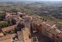 San Gimignano, vista delle torri dalla Rocca di Montestaffoli |
|||
 |
||||
Podere Santa Pia, April |
||||