Slow food and slow travel are part of a movement to return to traditional ways of traveling and
|
||||||||||
| N L | Walking in Tuscany | Trekking in Toscana | Endless scenic paths to explore
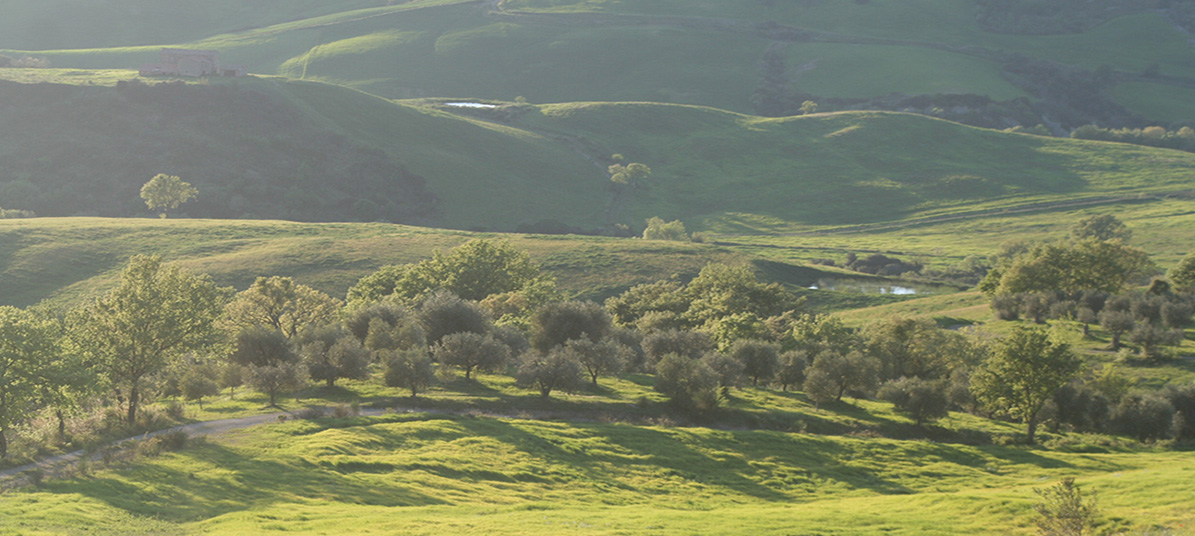
Of all the various modes of travel, the most intimate is also our most natural. Walking in Tuscany allows you an often overlooked and underrated relationship with your surroundings – and here they are truly amazing. Walking forces you to interact, take your time, and truly inhale the world around. Nowhere else on the globe are these intangible benefits more celebrated the famed Italian countryside of Tuscany. Southern Tuscany is an undiscovered jewel, the area provides both a cultural feast and a natural one. A world off the beaten track, where wooded hills, valleys, rivers and lakes frame a unique historical and archeological paradise. From the Etruscans to the Romans and from the Middle Ages through the Renaissance to our present times, history of mankind has left, layer after layer, its trace in an incredible succession. It is difficult to find elsewhere so many memories of different eras all together and in such a special setting.
|
|||||||||
|
||||||||||
walking Map | Montalcino | Val d'Orcia | Pienza |
||||||||||
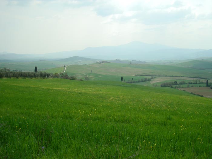
Immerse yourself into the rhythms of la dolce vita on an unforgettable journey through the Val d’Orcia, explore the winding cipress roads and architectural wonders around San Quirico d’Orcia, Pienza and Montalcino with our Hiking Suggestions.
|
||||||||||
 |
||||||||||
Walking in the Val d'Orcia, stunning landscapes between Monticchiello and Pienza |
||||||||||
|
||||||||||
Nature Reserve Cornate di Gerfalco, Gerfalco, Montieri, Provincia di Grosseto [1]
|
||||||||||
The Colline Metallifere are a mountain-hill group occupying the central-western part of Tuscany, divided between the provinces of Livorno, Pisa, Siena and Grosseto. The territory, with the exception of the Poggio di Montieri and Cornate di Gerfalco peaks, both above the 1,000 m, is mostly hilly, with a rich variety of minerary resources, whence the name. The metal resources of the Colline Metallifere were exploited since ancient times by the Etruscans: production reached its peak in the mid-19th century, declining quickly however afterwards. The numerous railways serving the mills are now mostly suppressed. The Colline Metallifere also include geothermic energy sources, part of which used in ENEL power plants at Larderello and Lago Boracifero. Rivers include the Cecina, the Cornia and the Merse. Gerfalco is situated in the area of the natural reserve “Cornate e Fosini”, (in the Geopark area, too) and it is a perfect starting point for the various trails all around: you can walk on the crest of the Cornate, look for old mines and tunnels, walk to the spectacular Castel of Fosini, or you can just hike around the reserve and enjoy the rural atmosphere of the countryside [2].
|
||||||||||
 |
||||||||||
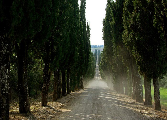
Villa Arceno near Castelnuovo Berardenga and Siena, reached by rows of centuries-old cypress trees |
||||||||||
The mountain is clothed in a forest of beeches, oaks, firs and chestnut trees, stretching from a height of a thousand meters to the top of the mountain.
|
||||||||||
 |
||||||||||
|
||||||||||
The area of Pitigliano and far to the south of Rome is characterised by tuff stone, a hardened type of volcanic magma. Southern Tuscany was once one of the most important centres of the Etruscans. There are numerous cave-tombs of that period around Pitigliano, caves cut deep into the tuff, that are today used as cellars and sheds. The Tuff Area is named after tufo, a volcanic, porous rock commonly used as a building material. The tuff has been carved over the centuries to build houses, cellars, tombs or used to make "tufi", big square bricks which are typical of the villages and towns of this area of the hills of the Maremma.
|
||||||||||
 |
||||||||||
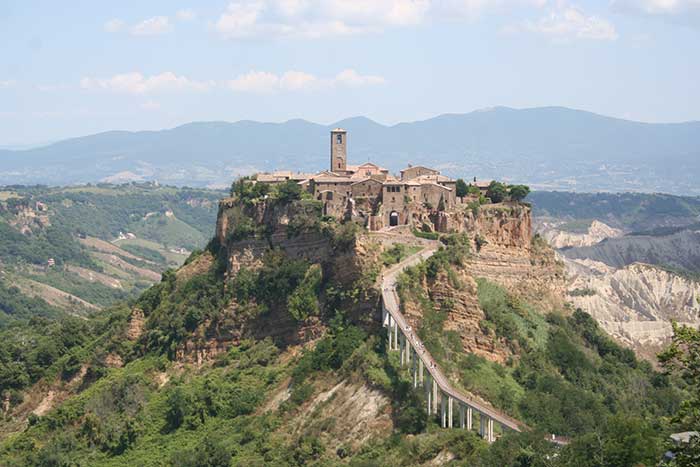
Civita di Bagnoregio |
||||||||||
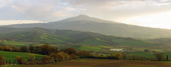
| The Maremma landscape is varied. Hills gently degrading towards the sea, whose main colours are intense green in spring and golden yellow in summer, with the presence of olive-groves and vineyards and also woods of cork-oaks and flowering ash full of mushrooms if it rains in summer. The fertile plain too is accurately cultivated and studded with the white rural houses. Many pine forests grow along the coast, wide shores of very fine siliceous sand with its characteristic sand dunes rich in Mediterranean macchia, the brush. Maremma includes 160 km of shoreline. The stretches of sandy and rocky coastline allow all sea lovers to find the perfect place for them. Moreover, the vast pine tree forests which border the beaches of the Maremma are a real naturalistic treasure and so are the few areas where the lagoon and swamp ecosystems have survived urbanization, reclamation or simple draining, such as the nature reserve of the Diaccia Botrona near Castiglione della Pescaia, and the Parco Naturale della Maremma between Alberese and Talamone. Grosseto can be considered the capital of the Maremma. The area around Grosseto and the coast, with Marina di Grosseto, Castiglione della Pescaia and the small villages that lie in the plain between the city and the coast, represents the heart of the Tuscan Maremma. Inside the Follonica Gulf, in the Bandite di Scarlino reserve, which is divided by a small promontory from Punta Ala, among a multitude of small caves, you will find Cala Violina. The beach's name derives from its very rare characteristic (it appears there is only one another beach with such a peculiarity) by which, steeping on the sand, the latter will echo back the harmonious notes of a violin. |
||||||||||
 |
||||||||||
The Natural Reserve of Diaccia Botrona, near Castiglione Pescaia |
||||||||||
| In the south, the Tombolo della Feniglia is considered to be the more chic and beautiful beach. La Feniglia is an enormous sand dune 6-8 km long and 1½ km wide that connects Monte Argentario to the mainland at Ansedonia in the south of the peninsula. The beach is the most famous in the area. A major feature of La Feniglia are the Mediterranean pine trees that run down the centre of the dune providing welcome shade during the heat of the day. There is a road that runs down the middle of the dune, where cars are not allowed. |
||||||||||
 |
||||||||||
Tombolo della Feniglia, a forest preserve of stone pine trees runs the length of the beach
|
||||||||||
 |
||||||||||
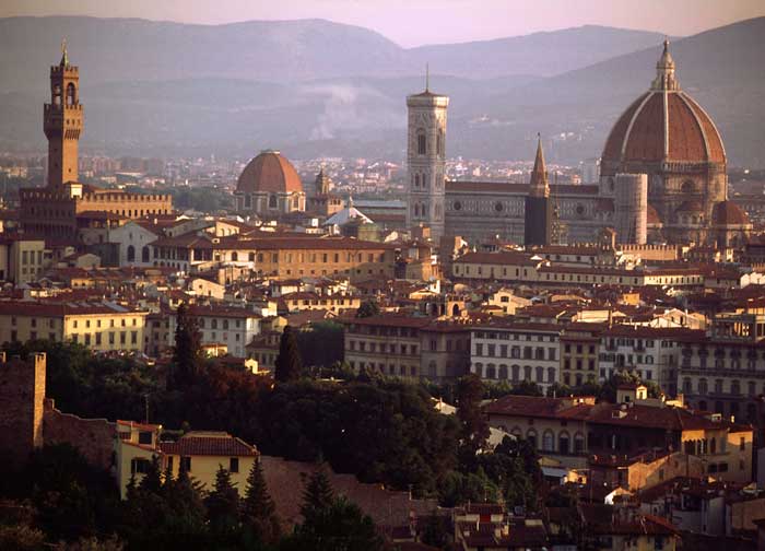
Florence, view from Piazza Michelangelo |
||||||||||
| Florence, the capital Tuscany, is known for its role in bringing Europe out of the Dark Ages and into the Renaissance era, paving the way for world-changing art, architecture, exploration, politics, and business. The Renaissance first occurred inFlorence and continued to be more pervasive there than anywhere else. The city's economy and its writers, painters, architects, and philosophers all made Florence a model of Renaissance culture. Most of the major tourist sights in Florence are within easy walking distance of each other. It is possible to walk from one end of the historic center of Florence to the other - North-South or East-West in a half hour. Walking is not only an easy way to get around, it also offers the chance to 'take in' much more of the city life. Be warned though, that electric motor scooters are small enough to fit where cars cannot. They are silent but quick and in the summer they often times travel into the plazas. Some of the streets in central Florence are closed off to traffic, and many more are simply too narrow for buses to get through. Therefore, bus and car tours are not recommended. This is a very small, very compact city that really needs to be seen by foot. This selection of tours has been put together with a deep passion for Tuscany's history and culture.
|
||||||||||
|
||||||||||
[1] Foto LigaDue, licenziato in base ai termini della licenza Creative Commons Attribuzione-Condividi allo stesso modo 4.0 Internazionale [2] Source:Gerfalco: The Wonder of Geology | www.turismomontieri.it |
||||||||||
