| |
|
 |

|
|
|
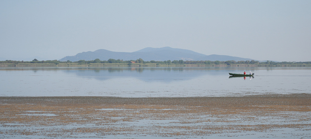
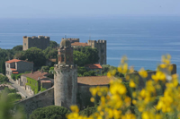
The Maremma in southwestern Tuscany offers both an inner hilly area dotted with vineyards and castles and a sandy coast with beautiful beaches. The area around Grosseto has been inhabited for millennia, and therefore spending a day or more visiting the many archaeological sites of this part of the Tuscan Maremma is well worth it. Roselle, which was once one of the twelve main Etruscan cities, and the Etruscan necropolis of Vetulonia are among the most remarkable historical sites in Italy.
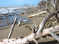
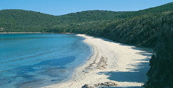
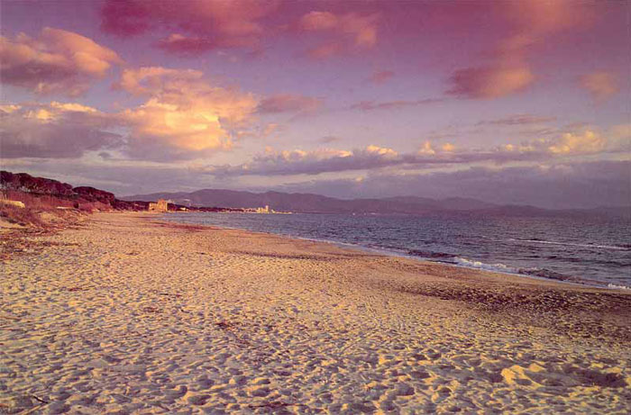
The Maremma seashore, overlooking the Tirrenian Sea, features some of the most beautiful sand beaches of Tuscany. More than ninety of the most beautiful of Tuscany beaches lie along Maremma's coastline.
Each year, the coast of the Maremma is awarded the Blue Flag recognizing the quality and the cleanness of the waters along its 160km of shoreline. The stretches of sandy and rocky coastline allow all sea lovers to find the perfect place for them. Moreover, the vast pine tree forests which border the beaches of the Maremma are a real naturalistic treasure and so are the few areas where the lagoon and swamp ecosystems have survived urbanization, reclamation or simple draining, such as the nature reserve of the Diaccia Botrona near Castiglione della Pescaia. Among the most remarkable coastal towns of the Maremma: Castiglione della Pescaia, Follonica, Punt'Ala, the Argentario Peninsula, Marina di Alberese in the Maremma Nature Park, Ansedonia, Capalbio, Orbetello and Talamone.
In this part of the Maremma there are many places of remarkable historic and artistic interest. This region has been populated since the Etruscan and Roman eras, and which then - in the sole case in this part of Italy - experienced the domination of the Spanish Empire, which left behind incredible stories of treasures and pirates. Last but not least, the Orbetello seaplane station hosted the takeoff of the first transatlantic flight in 1930.
|
| |
|
|
| |
|
The best coastal walks in the Tuscan Maremma
|
| |
|
The Maremma's most famous bathing sites combine natural beauty and trendy centres. They stretch from Principina a Mare and Marina di Grosseto through Castiglione della Pescaia to Punta Ala and the blue sweep of the Gulf of Follonica, and afterwards along the spectacular etruscan coast, the Costa degli Etruschi up to Piombino.
In the south they spread from the Ombrone delta into the wildest tiny gulfs within the Regional Park of Maremma.
Some of these beaches are quite isolated and wonderful, from a natural viewpoint. They are very often embellished by sand dunes, behind which evergreen bushes lead the way to a flourishing and thick pine forest. This type of wood is very closely tied to the history of this land with its past of drainages.
|
|
|
 |
|
|
The Ombrone River Delta located along the coast of Maremma Grossetana, where it flows into the Tyrrhenian Sea.
The vast pine tree forests which border the beaches of the Maremma are a real naturalistic treasure.
|
|
|
The territory |
|
|
|
|
|
|
|
|
|
|
|
|
|
Tarquinia
Vulci |
|
Maremma’s landscape, with its very special and peculiar mixture of woods, marshland, hills, shores and islands, and the neighbouring contiguity between Etruscan and Roman ruins and modern lively towns, evoke the words by George Dennis describing English travellers’ astonishment or the work by Carlo Cassola.
Before it was inhabited by the ancient Romans, central Italy, and in particular the regions of Tuscany and Lazio, were populated by the Etruscans: a highly developed civilisation the traces of whose artistic talent and architectural ingenuity can still be seen to this very day, in a number of fascinating archaeological sites.
The ancient Etruscan burial grounds are, arguably, the most impressive of all these, and in particular the necropoli of Cerveteri and Tarquinia, both of which awarded UNESCO world heritage status.
ust a few kilometers from Tarquinia, lies the town of Canino, at the entrance to the Vulci Naturalistic Archaeological Park. This part of Lazio, known as Maremma Laziale, was once home to the important city state of Vulci, the ruins of which can still be admired. The Tomb of Francois, Lake Pellicano, the Badia Castle and Museum: all these fascinating sites are located within the 900 hectare Park.
Walking in Tuscany | The Naturalistic Archeological Park of Vulci
|
|
Vulci, strada Etrusca |
| Capalbio |
|
Capalbio is a beautiful medieval town in southern Maremma. The Municipality is the most southwestern municipality in Tuscany along the border with Lazio.
Within the Mediterranean macchia of Capalbio, Daniel Spoerri’s garden and Niki de Saint Phalle’s sculptures represent two contemporary joyful embraces between arts and nature.
Tarot Garden (Giardino dei Tarocchi)
Niki de Saint Phalle, born Catherine Marie-Agnès Fal de Saint Phalle on October 29, 1930, was a French sculptor and film maker.
In 1978, she began work on a series of 21 large-scale sculptures meant to represent the main figures depicted on Tarot cards. The mosaic covered statues were constructed on the estate of Carlo and Nicola Carracciolo at Garavicchio in Tuscany.
The project was inspired in part by Gaudi's famous Park Güell, another sculpture and architectural garden, which is located in Barcelona.
The garden is open from the 1st April until 15th October 14.30 – 19.30
January – March and November – December on the first Saturday of each month entrance is free of charge from 09.00 – 13.00
The "Giardino dei Tarocchi" is located at Garavicchio, just outside of Capalbio
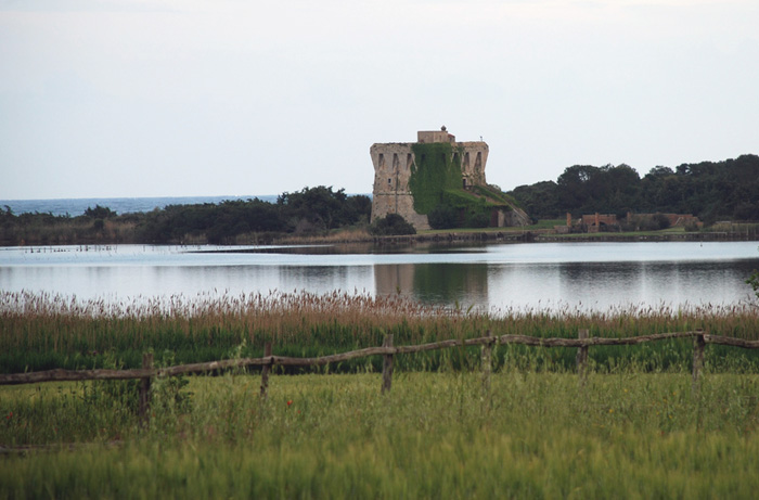
Near Capalbio, between the railroad tracks and the seashore, there is a nature reserve run by the WWF that stretches north and south for about 15 km. You can't see the beach from the road; what you see are fields of poppies, if in season, or grain and the dunes with the macchia mediterranea (typical vegetation of the Mediterranean). On the other side of the dunes is the sea, at less than 1 km.
Lago di Burano, a salt-water lake. The reserve is usually closed during the summer months of July and August but the main path to the lake is always open. You can do some bird watching here. I've seen flamingos on several occasions and there are always swans.
|
|
 |
| |
|
Lago di Burano and Tombola di Feniglia
|
|
|
|
|
This promontory harbors the largest lagoon on the Tyrrhenian Sea as well as one of Italy's most important bird sanctuaries. About halfway between Rome and Florence, it makes a wonderful choice for birdwatchers. Take a guided tour of the WWF oases at Orbetello (open Sept. 1-April 30) and Burano (open Aug. 1-May 31) at 10 am and 2 pm on Thursdays and Sundays.
Or you can go on your own: for Orbetello drive along the southern edge of the promontory (called Tombola di Feniglia); for Burano Lake take the northern shore road and then walk along the dunes. Or take the 4-hour walk around the coast from Burano to Feniglia.
The Buranaccio Tower stands at the centre of the narrow sandy isthmus separating lake from sea.
Walking in Tuscany | Lago di Burano and Tombola di Feniglia
|
|

La Torre di Buranaccio, Lago di Burano, a salt-water lake near Capalbio
|
| |
|
|
| |
|
Ansedonia and the ancient Roman town “Cosa”
|
|
|
| |
|
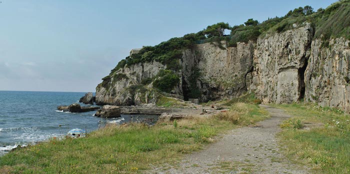
At the mainland end of the Feniglia tombolo Ansedonia rises above the sandy shore, a green contrast to the darker Mediterranean maquis of the Feniglia.
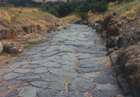
On top of the hill are the evocative ruins of Archaeological Area of Cosa, Roman colony founded in 273 BC, perhaps on land confiscated from the Etruscans. Its strategic position allowed to control the sea and land flow. Cosa seems to have prospered until it was sacked in the 60s BC, perhaps by pirates. Today is an important archaeological site in Maremma. The coastline is steep and rocky: “la Tagliata” is a canal cut in the rock in Roman times, still visible; and “lo Spacco della Regina” is a natural cleft in the rock on which the sunlight produces fantastic light and shade effects.
The cliffs, heated by the Maremma sun, connect the long beach of Feniglia and the Taglia Etrusca, a magnificent channel cut through the rock by the Romans, designed to ensure the flux and reflux of water into the ancient port.
Vulci | The archaeological areas
The city
On the site of the ancient city, it is possible to see the remains of a villa dating from the 1st century BC, a long stretch of a Roman road, the foundations of an Etruscan temple and the remains of two doors in the city walls.
The necropolises
Four necropolises dating from the 8th century BC have been found around the city of Vulci. The tombs of the 6th and 5th centuries BC are generally of the sarcophagus type. Only a few graves are an exception, including the large tumulus of the "cuccumella". The habit of placing statues of imaginary animals to guard the tombs is characteristic of Vulci. Immensely rich burial treasures have been found in these tombs, in particular a large number of ceramics of Greek production, and bronze objects of local production. In the second half of the 4th century BC, the tombs became of the hypogeal type and reproduce the shapes of the dwellings. The most well-known of these hypogea is the François tomb, famous for its paintings (now at Villa Albani in Rome) portraying, as well as the deceased, episodes from Greek mythology together with characters from Etruscan myths.
|
|
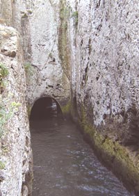 Spacco of Bagno della Regina
 (Queen's Bath)
|
| |
|
|
|
|
| |
|
|
| |
|
|
|
|
Monte Argentario
Orbetello
Tombolo Feniglia
Ansedonia |
|
The territory around Orbetello is extremely varied. The lagoon's wetland is divided into two pillows by the sea (il Tombolo della Feniglia and Tombolo della Giannella) characterized by long sandy beaches, pinewood forests and Mediterranean bush, while next to the Talamone and Ansedonia heights, the coastline is full of cliffs. The hinterland offers lower heights and vast plains where cultivations alternate with Mediterranean bush.
After the Medici defeated Siena in 1557 Orbetello became the capital of the Stato dei Presidi under Spanish rule. The Spanish transformed it into an important naval base and realized various fortifi ed structures which still characterize the entire territory.
Orbetello is joined to the Argentario promontory by two long, golden sand dunes, known as the Tomboli della Feniglia e della Giannella that offer the visitor kilometres of enchanting, unspoilt beaches.
The Feniglia Tombolo is a thin stripe of sand which connects the Argentario Headland to the coast, separating the Orbetello Lagoon from the open sea. The pine forest on the Tombolo is a protected forester reserve. In only 100 metres it’s possible to admire both the marine ecosystem than the lagoon one. Along the track there are a good number of bird-watching hides.
Tombolo della Feniglia is accessible from Ansedonia. Once you have parked your car, you can enter into the natural reserve, by following a country path either by foot or on bicycle. It is a fantastic nature walk, where you can pass deer grazing and at regular intervals follow the paths which lead onto the beach. In the central part of “Tombolo” the beach is semi-deserted even in high season.
Spiaggia Feniglia. This impressive beach is 7 km long and it has fine white sand and is backed by a lush pine forest. It ends with the lagoon of Orbetello. It can easily be reached from Porto Ercole or from Ansedonia. Although there are some beach resorts, the majority of the area consists in uncultivated beaches.
Tombolo della Giannutri is a very small paradise , it is 500 mt. large and more or less 5kms long, a beautiful walk. In the past Giannutri had already charmed the Romans who built a port and beautiful patrician villas. They call the island Dianum in honour of Diana the hunting goddess and because of its half-moon shape.
|
|
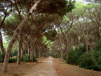
Pineta della Feniglia
A forest preserve of stone pine trees runs the length of the beach
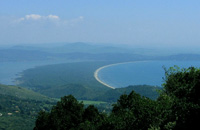
Tombola di Feniglia, view from
Monte Argentario
|
| |
|
The most beautiful beaches of Tuscany | From Principina a Mare to Ansedonia
|
|
|
| |
|
|
|
|
| |
|
 |
| |
|
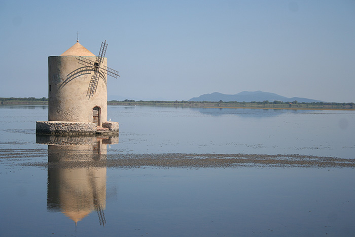
One of the symbols of Orbetello, the so-called Spanish Windmill, an untamed stone Don Quixote that guards the town.
|
| |
|
The Natural Park of Maremma | Parco Naturale della Maremma
|
| |
|
|
|
|
Talamone
Alberese |
|
 |
| |
|
Parco Naturale della Maremma
|
|
|
The Maremma Regional Park (Parco Regionale della Maremma), also known as Uccellina Park (Parco dell’Uccellina) covers a coastal area between Principina a Mare and Talamone near Grosseto, Magliano in Toscana and Orbetello.
The Maremma Park, with its range of hills descending towards the sea to reach the sandy beaches and cliffs, was established in 1975 and spreads from the mouth of the Ombrone river till it reaches Talamone, along 25 km of the breathtaking Tuscan coastline surrounded by marshland, pinewood forests, tilled land and pastures. The Maremma Park extends over a rectangular area of 100 square kilometers, and borders in the south and southwest with the sea, facing it in the southern part with a high coast subject to erosion. This kind of coast is followed in the north by beaches where the vegetal covering consists of several pioneer species which can adapt to the difficult sandy and brackish environment and which are replaced by typical species of the Mediterranean maquis as you leave from the shoreline.
From a naturalistic point of view, the complex formed by Uccellina Mountains, the pinewood of Marina di Alberese, the mouth of the river Ombrone, and the Paludi della Trappola represents a precious mosaic of ecosystems shaped by man in different periods and ways, characterizing the landscape without degrading it.
The Park is open all year round, all week.
To enter, purchase tickets at the entrance at the Visitor Center. It is possible to take a tour on your own or in a group, with a guide or not, depending on the time of the year.
To enter the Park, purchase tickets at the entrance at the Visitor Centers.
The Visitor Centres of the Park (Centro Visite del Parco) are situated in Alberese and in Talamone.
Alberese Visitor Center
Via del Bersagliere, 7/9 - Alberese (Gr)
Tel. +39 0564 407098 - Fax. +39 0564 407278
Open every day including holidays with the following timetable: from October 1 to March 22, 8.30 a.m. to 1.30 p.m.; from March 23 to September 30, 8.00 a.m. to 5.00 p.m.
Visitor Center and Talamone Aquarium
Via Nizza, 12 - Talamone (Gr)
Tel. +39 0564 887173 - Fax. +39 0564 887173
Open every day including holidays with the following timetable: from September 1 to June 30, 8.00 a.m. to 1.00 p.m.; from July 1 to August 31, 8.00 a.m. to 12.00 noon and from 5.00 p.m. to 8.00 p.m.
More info
Map
View Map on Google Maps
Itineraries
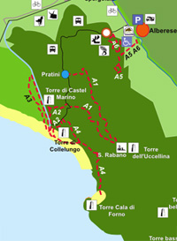
Within the Natural Park of Maremma is possible to make many routes. Most routes start from Alberese, while four routes start from Talamone.
The itineraries can be covered either individually or in groups, with or without a guide, depending on time of year:
In summer (June 15 to September 15): The itineraries A3-LE GROTTE and A4-CALA DI FORNO and P1-BIRDWATCHING are closed for fire risk. All other routes will visit with a guide and reservation, except routes A5/A6-FORESTALE/FAUNISTICO and A7-BOCCA D’OMBRONE accessible independently. The route A2-Le Torri need a guide, but not booking. Guided tours are provided in German, English and French for route A2-Le Torri.
In Spring, Autumn and Winter (September 16-June 14): During this time of year the tours are free with hours starting from 9.00 up to 1 hour before sunset. All routes are open. [1]
|
|
Parco Naturale della Maremma
A8 - Macchiozze
Marina di Grosseto
|
| |
|
From Alberese
|
|
|
| |
A1 |
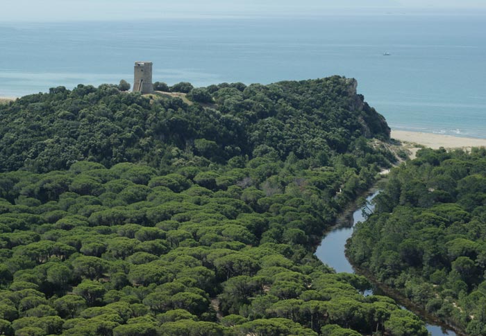
Abbazia di San Rabano and Torre Uccellina | The path to San Rabano
|
|
|
| |
|
Departure: Alberese Visitor Center with shuttle bus to Pratini. Itinerary: about 7.8 Km. Time: about 5 hours. Difficulty: challenging. The itinerary climbs up to the heart of the Uccellina mountains. In a broad clearing, set between tall holm-oaks, the whitish stones of the Abbey and S. Rabano Benedictine Monastery (11th century) are set against the sky. A short distance away, the Uccellina Tower (14th century).
The route begins in the area of Pratini (which can be reached from the Visitor’s Center in Alberese), where the path takes a steep climb up the hilly landscape that characterized by the thick Macchia Mediterranea. Along the path, you can admire a series of very beautiful panoramas that overlook pine groves and the Mediterranean coastline. The path continues up the hillside toward Poggio Lecci, which is located 417 meters above sea level and is the highest point in the park.
Then you will descend toward the ruins of the Abbey of San Rabano (a Benedictine monastery from the 10th century), which are surrounded by a suggestive wood. Next to the abbey, there is a watchtower that was part of a complex defense system along the coastline. Moving away from the ruins, you will once again enter the Macchia Mediterranea and descend toward the Tre Fonti spring, which was used in ancient times by the inhabitants of San Rabano. The route continues in descent toward the bottom of the valley, and ends at the olive groves of Collelungo. From here, you can easily reach Pratini, the starting point of the itinerary.
The San Rabano Abbey
The Benedictine Abbey of Santa Maria Alberese was built around 1000 AD with the name Santa Maria Alberese. After 1000 AD, it was surrounded by walls and watchtowers because of its strategic position along the coastline. It was at its most beautiful in the 12th century. From the 1200s onwards, due to the crisis experienced by the Benedictine order of monks, the abbey passed on to the Knights of Jerusalem in 1307. In the mid-15th century, they tore down the fortifications, anticipating its eventual decline. Santa Maria Alberese was left abandoned the following century and became the place where the hermit Rabano lived. He was later sanctified and the abbey was given his name.
Walking in Tuscany | From Alberese to San Rabano | From Alberese to Cala di Forno |
|
Ruins of San Rabano Abbey |
| |
A2 |
Le Torri
|
|
|
| |
|
Departure: Alberese Visitor Center with shuttle bus to Pratini. Itinerary: about 5.8 Km. Time: about 4 hours. Difficulty: medium. The Castelmarino tower (12th century) can be reached by crossing a thick wood. Below, a luxuriant pine wood forest and the magnificent beach lead to the Collelungo promontory and Tower (16th century).
|
|
|
| |
A3 |
Le Grotte
|
|
|
| |
|
Departure: Alberese Visitor Center with shuttle bus to Pratini. Itinerary: about 9.7 Km. Time: about 4 hours. Difficulty: easy. A quiet walk in the pinewood forest to reach a canal inhabited by terrapins. Only a short distance away, the Caprarecce cave, once a shelter for shepherds and herds. Other caves placed at different heights, open on to ancient rocky cliffs.
|
|
|
| |
A4 |
Cala di Forno
|
|
|
| |
|
Departure: Alberese Visitor Center with shuttle bus to Pratini. Itinerary: about 12.8 Km. Time: about 6 hours. Difficulty: challenging. Brooms, cists and rosemary alternate with bush and woods of secular juniper. At the end of the path, the marvelous Cala di Forno bay unfolds, rewarding visitors with an unforgettable view overlooking the sea after the long walk.
|
|
|
| |
|
Other itineraries: A5/A6-Forestale/Faunistico, A7-Bocca d’Ombrone and P1-Birdwatching
|
|
|
| |
T1
|
From Talamone
Punta del Corvo
|
|
|
| |
|
Departure: Talamone Visitor Center. Itinerary: 3 about 3 Km. Time: about 3 hours. Difficulty: medium. Garigue and bush characterize this itinerary which allows the Punta del Corvo ridge to be reached in the shortest time possible. Many panoramic views along the itinerary overlook the beautiful coastline.
|
|
|
| |
T2 |
Le Cannelle
|
|
|
| |
|
Departure: Talamone Visitor Center. Itinerary: about 6.5 Km. Time: about 5 hours. Difficulty: challenging. Departing from Punta del Corvo, the itinerary reaches an ancient customs road. Cists and rosemary are found along the path which later gets lost into the thick bush. The small Cannelle bay greets the visitor with its crystal clear waters and its breathtaking view over the Park’s coastline.
|
|
|
| |
T3 |
Poggio Raso
|
|
|
| |
|
Departure: Talamone Visitor Center Itinerary: about 10 Km Time: about 6 hours Difficulty: challenging Between the magnificent views of the coastline and the Maremma hinterland, the path reaches an area where the thick vegetation and presence of caves has allowed dangerous and legendary bandits to hide in the past.
|
|
|
| |
|
Castiglione della Pescaia is a 15th century village that lies along the ocean in Tuscany. While its history is mainly connected to the Etruscan people, whose traces you can find everywhere, nowadays its main property is the pureness of its unspoiled surroundings, extending from the clean beaches to places of great naturalistic importance, like the nearby Parco Naturale dell'Uccellina.
The hinterland of Castiglione della Pescaia hosts one of the most important wetlands of the Tuscan coast: the Natural Reserve of Diaccia Bortona, where the small WWF Oasis of Marze is located. Beyond the historic centres of Castigllione della Pescaia, Vetulonia and Scarlino, the villages of Buriano and Tirli as well as isolated archeological monuments like the Roman villa of Puntone and the Etruscan necropoli of San Germano and Poggio Tondo are all worth visits. Outdoor enthusiasts will also find the nearby Nature Reserve of Diaccia Botrona interesting; it is an important wetland reserve that offers hiking trails and opportunities for mountain biking and viewing wildlife. When it's time to unwind, the area also offers numerous accommodation options.
|
|
Castiglione della Pescaia |
| |
|
From Marina di Grosseto to Castiglione della Pescaia - 13 km
This level trail crosses the pine woods between Castiglione della Pescaia and Marina di Grosseto, heading along the marshlands of Diaccia Botrona. Don't miss the suggestive Casa Rossa (or Casa Ximenes), built between 1766-1768 to regulate the flow of water towards the sea. The trail can be interrupted at Diaccia Botrona: ask for information before departure.
|
|
|
| Castiglione della Pescaia |
|
The Nature Reserve of Diaccia Botrona
|
|
|
| |
|
|
|
|
| |
|
 |
| |
|
|
|
|
| |
|
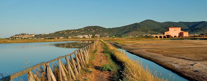
Diaccia Botrona is a beautiful nature reserve in Maremma. Located between Castiglione della Pescaia and Grosseto, this protected area in Tuscany stretches for over 1000 hectares and is one of the most important wetlands in Italy because of its wildlife.
The nature reserve was created after the drainage of the old Lake Prile or Preglio, that took up this flat area. The lake was drained almost completely during the huge drainage works ordered by the Grand Dukes of Tuscany during the 18th century to defeat malaria.
Today Diaccia Botrona is an important wetland, a marshy area of land with unique characteristics of international importance. As a matter of fact, many species of plants and animals can be found here. The access to the protected area is free and with a good telescope and a pair of Wellingtons you can observe different species of birds, such as hawks, herons, wild geese and ducks, but even various mammals such as foxes, badgers, hedgehogs and porcupines, or reptiles such as tortoises, tree frogs and grass snakes. In addition, Diaccia Botrona is one of the few areas in Italy where flamingos live.
Within the nature reserve, near Castiglione della Pescaia, there is a modern multimedia museum set in the Casa Rossa, the Red House, commissioned by Grand Duke Pietro Leopoldo in 1765 to engineer and mathematician Leonardo Ximenes. The building was projected as a big hydraulic damper, so that the lake didn't have to be drained completely. The museum is a great observation point, as well as a center for information and research.
Walking in Tuscany | The Nature Reserve of Diaccia Botrona
|
|
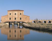
Casa Rossa Ximenes |
| Scarlino |
|
From Scarlino to Portiglione - 10 km
From the castle at Scarlino the trail crosses a chestnut grove, passing on the left the paths toward Poggio Tondo and Tirli, and heads up between Fosso Fedeli and Fosso dell'Uccelliera. From the foot of Monte di Muro it continues along the crest to Poggio Scodella where you can admire a beautiful view of the Tyrrhennian Sea and the Isle of Elba.
From Portiglione to Torre Civette and Punta Ala - 11 km
This itinerary, among the most classic of the Tuscan coast, follows the gravel road which passes the beaches of Cala Francese, Cala Martina, Cala Violina and Cala le Donne. From the camp grounds at the mouth of the Alma River a path runs between the street and the beach to Punta Ala.
From Torre Civete to Portiglione through the Val Martina - 9 km
Together with the previous itinerary, this itinerary creates a beautiful ring-path. It passes many farmhouses and small villages, through the woods of Poggio Moscatello with the Val Martina on the right. After it opens on to the sea, the path turns right at the feet of Poggio la Guardia. A gravel road and the provincial Collacchie road head back towards Portiglione.
From Val Martina to Cala Violina - 3.5 km
The shortest and most popular itinerary in this area can be reached by car from the provincial Collacchie road (follow indications for Cala Violina) and follows a gravel road.[2]
|
|
|
| |
|
|
|
|
| |
|
 |
| |
|
|
|
Cala Violina
|
|
|
A walk close to the sea, towards Cala Violina and Cala Martina
|
|
|
| |
|
The beach of Cala Violina is perhaps the most beautiful bay of all of Tuscany. The beach owes its name to the particular nature of the fine white sand it has which tends to produce a "violin-like" sound when you walk bare foot on it. It is enclosed in two different headlands covered with the Mediterranean Vegetation, Cala Violina is also renowned for its transparent waters and fabulous seabed with rows of Posidonia Oceania and masses of sandstone and fish of any dimension.
The beach of Cala violina is in the heart of the Natural Reserve of "Bandite di Scarlino" in the province of Grosseto. The "Bandite" are a forrest complex of great dimensions between Castiglione della Pescaia, Gavorrano, Scarlino and Follonica. If you are in Tuscany and you enjoy trekking and mountain biking as well as resting on the beach, you can also reach Cala Violina by following the path called "il sentiero delle Costiere" (the most beautiful of the entire area), which you can reach only on foot, with a bike or by horse.
The path reaches spectacular cliffs that develop along the coast (it extends from Cala Violina to Cala Martina and Cala Francese) and it develops all along the coast. It is level and easy to walk through so you can relax as you enjoy the scenery on the bay of Follonica, the sunset on Piombino, Isola d'Elba, Isola di Cerboli, Montecristo, the peninsula of Punta Ala and (if it's your lucky day) the mountains of Corsica.
|
|
|
| |
|
View Cala Violina and Cala Martina in a larger map |
| |
|
|
| |
|
Indications to find the path
From Follonica take the provincial fairway from Collacchie towards Castiglione della Pescaia and turn right at the lights when you're at Puntone towards the Tourist Dock. Close to the Cantuccio Restaurant, you will find parking and a few meters towards the restaurant you will find a gate that leads to path number 1 which goes to Cala Violina, on foot or by bike.
Cala Violina is 4 Km away and you can reach it in a hour. The path unravels through the "Macchia Mediterranea" (=Mediterranean Vegetation). After 2 Km you will reach Cala Francese and Cala Martina Tombstone and a Monument along the path remember Garibaldi who fled from the Papal Guards in 1849 from that point. After another 2 Km, you reach cala Violina.
Cala Violina can be reached through yet another path: the gravel alley of Val Martina. From Puntone you take the highway of Collacchie heading towards Castiglione della Pescaia, then you turn right in a gravel way about 400 meters before reaching the Gas Station of Pian d'Alma. The indications for Cala Violina should be very visible around the farm Laschetti and you can leave your car in a Parking area and take the 2 Km walk towards Cala Violina.
Walking in Tuscany | A walk close to the sea, towards Cala Violina and Cala Martina
|
|
|
| |
|
|
|
|
 |
|
|
Beach in the Coastal Park of Sterpaia (with Torre Mozza)
|
| |
|
Coastal Park of Sterpaia
|
|
|
| |
|
The Etruscan Coast territory in Tuscany has much to offer hiking enthusiasts, or those who simply love to walk, with its spectacular fine sand beaches, natural oases, bushland parks and natural uncontaminated environments.
The Coastal Park of Sterpaia extends over 296 hectares, out of which 17 hectares of sandy shores extending over 10 km, 124 hectares of dunal and retrodunal areas, 155 hectares of wood and agricultural glades.
This park is formed by bushland and a coastal area with characteristic fine sand dunes, situated along the stretch of coastline between Piombino and Follonica.
The Park of Sterpaia is ideal for walks or mountain bike rides, combining the pleasure of hiking through bushland with century old oak trees, with the pleasure of swimming in the crystal seas of the Gulf of Follonica, with all the typical natural features of the Maremma Livornese.
The purity of its waters and the numerous services available for swimmers have ensured this area has been awarded the “Bandiera Blu” (Blue Flag) for several years.
Walking in Tuscany | The Coastal Park of Sterpaia
Bosco della Sterpaia Loop trail | 4.91 km
From Torrze Mozza to the Coastal Park of Sterpaia | 2.90 km
Additional walk along Fosso Corniaccia | 2 km
|
|
Fosso Corniaccia |
| |
|
|
| |
|
|
|
|
| |
|
Park of Poggio Neri - Sassetta
|
|
|
| |
|
The Park of Poggio Neri is the ideal destination for hiking enthusiasts. The park is formed by a stretch of bushland over an area of approximately 7 hectares, dominated by chestnut trees and holm oak trees, including several trails which can be followed either on foot, mountain bike or horseback.
Walking in Tuscany | The Forestry Park of Poggio Neri |
|
|
|
|
|
|
|
|
|
|
|
|
|
|
|
|
|
|
|
|

Trekking | Walking in Southern Tuscany

[1] Source Maremma Tourist Information Office
[2] Source: Province of Grosseto)
|
|
|
|
|

|
|
|
|
 |
|
| |
|
 |
|
|
|
 |
|
|
|
 |
|
|
|
 |
|
|
|
|
|
 |
|
|
Cosa (Ansedonia) rises on a promontory that is connected via a famous stretch of land called Tombolo di Feniglia, in the Agrigento peninsula. The curious name of the ancient location relates to a small Etruscan settlement that was initially established there. The territory of Cosa was invaded in the 5th century by the Visigoths under Alaric, and after this it was the last bastion of the Arians, who changed the name of the town to Ansedonia. Ansedonia is located south of the Cosa area, and it is a modern and pleasant beach resort facing the clear waters of the Gulf of Agrigento. Below, on the slopes next to the sea, is the location of the tranquil residential area, which has numerous villas embedded in its greenery, in direct contact with nature.
The cliffs, under the warm Maremma sun, lead from the long beach of Feniglia to the "Tagliata Etrusca", a magnificent canal dug out of the rock by the Romans to permit the flowing and backwashing of sea water in the ancient canal port.
|
| |
|
 |
|
|
|
|
|
|
|
|
|
|
|
|