|
The Maremma in southwestern Tuscany offers both an inner hilly area dotted with vineyards and castles and a sandy coast with beautiful beaches.
|
||||||||||
 |
|||||||||||
Pitigliano |
|||||||||||
|
|||||||||||
Walking in Tuscany | The Hills of the Etruscan Maremma |
|||||||||||
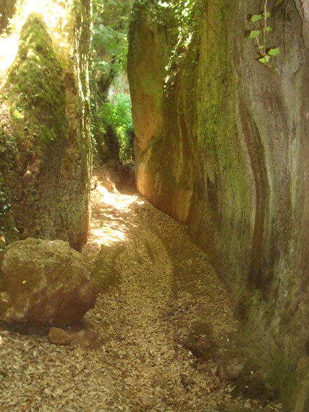
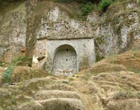
| The hillsides of porous volcanic tufa are very friable which made it easier for the Etruscans to carve out the hundreds of tombs and various vie cave. These ancient routes linked the Etruscan sacred places. Fifteen of these megalithic corridors still weave through the surrounding woods, all but invisible to the unknowing eye. The Roman and Etruscan tombs, carved into the tuff, are mostly temple or tumulus shaped. The tombs of the lower social classes are very often just rectangular holes in the ground or in a rock flank, and are cold. Many of them are still used today as sheds, for tools or storage, the columbarium. The Vie Cave The Vie Cave (in English excavated roads), also known in Italian as Cavoni, are an impressive road network linking an Etruscan necropolis and several settlements in the area between Sovana, Sorano and Pitigliano, consisting mainly of trenches excavated as nearly vertical cliffs in tuff, sometimes over twenty feet high, possibly serving as an effective defense system against invaders. In Roman times, the Vie Cave became part of a road system that was connected to the main trunk of the Via Clodia, an ancient road linking Rome and Manciano, through the city of Tuscania, which branched off from the Cassia road in Lazio territory. |
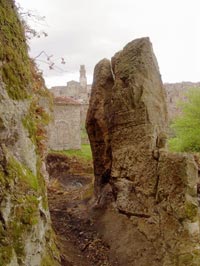 Via Cava near Pitigliano |
||||||||||
|
|||||||||||
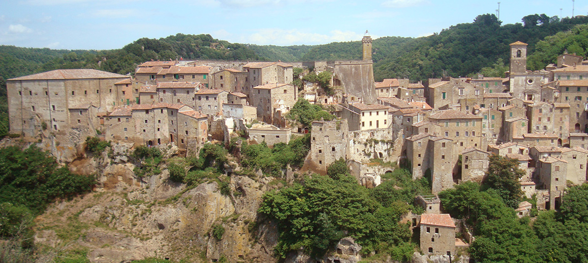
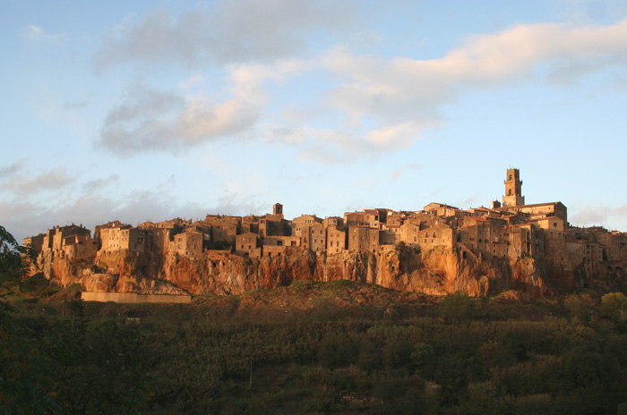
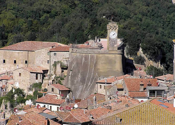
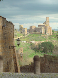
| Pitigliano | Pitigliano situated on a steep tuff rock, high above the Olpeta, the Fiora and the Lente rivers, is one of the most scenographic villages of Tuscany. In particular arriving from the direction of Manciano, along road n° 74, in correspondence of the curve in front of the church of the Madonna delle Grazie which provides a scenographic backdrop to the town. In 1293, the Orsini family moved its base from Sovana to Pitigliano, built up the town's defenses and fortified their home. The Palazzo Orsini has its water supply brought in by an impressive aqueduct, built below the fortress in 1545. The Orsini Fortress stands at the entrance to the old town and overlooks the historic center. Next to it runs the impressive mediaeval aqueduct, that supplied the town with water. Of further interest is the Jewish history of Pitigliano. For a long time there was an extraordinary large Jewish community, that influenced the cultural life of the town. The major attraction of Pitigliano, however, is probably its outskirts, very rich in Etruscan and medieval remnants. In the important Necropolises of Poggio Buco, located approximately 8 km from Pitigliano, there are notable varieties of tombs in rooms from the 7th to 6th centuries B.C. Walk from Pitigliano to Sovana a short but extraordinary walk, following an Etruscan path carved out of living rock three thousand years ago. |
 Het Palazzo Orsini on the Piazza della Repubblica, and the aquaduct over the Via Cavour Het Palazzo Orsini on the Piazza della Repubblica, and the aquaduct over the Via Cavour |
|||||||||
| From Pitigliano to Sovana 8 km |
|||||||||||
| From Sovana go back to Pitigliano and pass the turn of to Pitigliano and proceed to Sorano. Two kilometers before you arrive to the village are the Necropoli di San Rocco. From here you can reach Sorano by foot following a via cava that leads you to il Fosso del Puzzone, il Piano Conati, continue on Via di Poggio Cani further to Pitigliano. |
|||||||||||
Walking through the Etruscan necropolis of Sovana | From Pitigliano to Sovana, along the vie caveand the Necropolis of Poggio Felceto | Download pdf
|
|||||||||||
|
|||||||||||
| Sovana | Sovana was one of the principal Etruscan cities and was reborn in the Middle Ages when it became the property of the Aldobrandeschi family. Once you have crossed the threshold of the Rocca Aldobrandesca, you can continue on to Piazza del Pretorio, which has several lovely buildings, such as the Church of Santa Maria, dating from the late Romanesque period, the Palazzo dell’Archivio, with its strange clock, and, facing the church, the Palazzo della Loggia and the Palazzo Pretorio. In Sovana, you can also experience a walk in the enchanting Vie Cave, imposing walkways excavated from the tufa by the Etruscans, perhaps as communication lanes, perhaps for magic rites. Among the best known is the Cavone. |
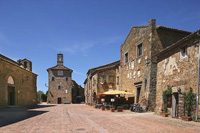 Sovana |
|||||||||
Walking through the Etruscan necropolis of Sovana | From Sovana to Via cava di San Sebastiano and the Tomba della Sirena (Siren Tomb) | Download pdf
|
 La Tomba della Sirena |
||||||||||
Walking in southern Tuscany | From San Martino sul Fiora to Sovana
|
|||||||||||
 |
|||||||||||
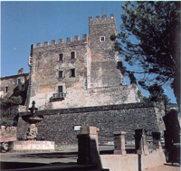
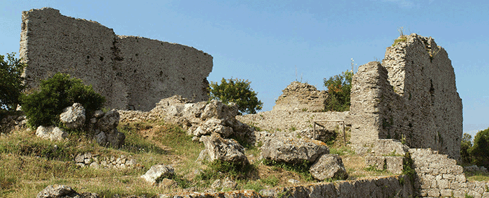
Sorano, Masso Leopoldino |
|||||||||||
The particularity of Sorano is its strategic position, impregnable in its defence of the city and excellent at an aesthetic view. As its name clearly indicates, this castle was built in the XVIII century when the Lorraine grand dukes ruled the area. It is located north of the tufaceous spur on which the village stands and, together with the fortress, dominates the entire surrounding settlement below. |
|
||||||||||
Walking through the Etruscan necropolis of Sorano | From Sorano to Vitozza, along the vie cave and the Necropolis of Poggio Felceto (download pdf)
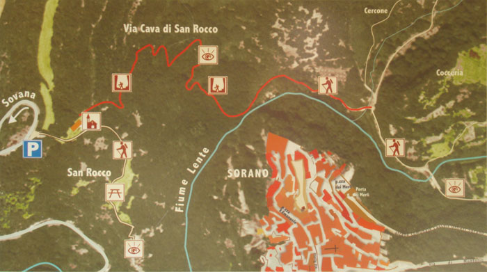
Via Cava di San Rocco |
|
||||||||||
| In the immediate vicinity of Sorano, in a panoramic position above the river Lens, is also the setting rupestre di San Rocco. The necropolis is situated along the tufaceous ridge that defines the valley of the River Lente. It can be reached by following the provincial road that joins Sorano and Sovana. To get there we have to cross the bridge over the river and then go up a series of hairpin curves dug into the tufa. The necropolis consists of chamber tombs carved into the rock that date from the III-II centuries B.C. The via cava di San Rocco, that leads to the bottom of the valley below Sorano. Coming from the direction of Sovana, two kilometres from the village of Sorano, we meet the well-marked sign to the necropolis of San Rocco and its church. We cross the bridge that brings us to the indicated area, where we can admire the necropolis and the splendid balcony that looks over the village and, right behind the church, we descend the via cava di San Rocco, that leads to the bottom of the valley below Sorano. |
 |
||||||||||
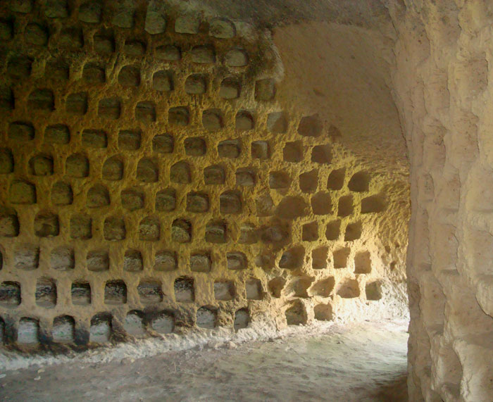
This tufa ridge, which until today has been impossible to reach because of the provincial road built in the nineteen thirties, features an exceptional number of dovecotes. They were studied by Ranuccio Bianchi-Bandinelli in 1929, who compared their construction characteristics to those of the dovecotes built in Rome during the Augustan age (1st century A.D.) and were re-used from the early Middle Ages onwards to breed doves. Their highly developed architecture (in some cases access to the quadrangular rooms, the walls of which are completely occupied by the small cells, is through a small vestibule) and state of preservation make them unique, even when they are compared to the numerous specimens that can be found throughout the area of Sorano.
|
|||||||||||
| Manciano is a town in a scenic location that has been nicknamed the “spy of the Maremma” because of its scenic location. Manciano was once a fairly important market town for the area of the Albegna and Fiora valleys, with a stronghold already recorded in the twelfth century. A brief occupation by Siena (1419-1455) left the town an imposing fortress built around 1424. The most important site in the comune is Saturnia, an old Etruscan town with medieval walls, remains of a Roman road, and best known for its thermal springs dating to the Roman period and still in use today. The comune is further known to students of Late Antiquity as the place where the famous silver platter of Ardabur Aspar, consul in 434, was found (in the Fosso Castione, a creek near Marsiliana). The Marsiliana Nature Reserve covers an area of about 450 hectares, almost all of which is contained in the Interprovincial Park of Montioni. The Reserve is open to visits only after booking. For information contact the Administration Office of the Forest Rangers (tel: 0566/40019). The densely built town centre of the frazione Montemerano, crowned by its leaning Torre di San Lorenzo, is contained within its ancient walls. Montemerano became a power center of the signori dei Baschi, who dominated the comune. The thirteenth-century church is dedicated to San Lorenzo; frescoes remain on its walls, and a polyptych by the Sienese painter Sano di Pietro. At a short distance, in open countryside, is the church of the Madonna del Castuzzo. |
 Manciano |
||||||||||
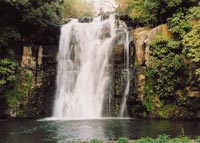
Saturnia's springs have been appreciated since Etruscan times, but it was the Romans and their penchant for opulent baths that turned it into a proper and popular spa. The via Aurelia, one of the famous Roman roads, transported affluent visitors from the capital city. Ruins remain to testify of its one-time grandeur. while the town has Roman ruins, a well-preserved castle, and loads of atmosphere, the name Saturnia is associated with the town's main attraction rather than the village itself. Nowadays, the bubbly baths attract tourists from all over the world, drawn to its natural beauty and unique hot spring cascades. |
|||||||||||
Montemerano is a picturesque walled village situated on a beautiful hilltop. Montemerano maintains the look of an ancient medieval castle with it’s antique streets and quaint, charming houses. Cicloturismo in Maremma | Sulle strade dei campioni |
 Montemerano Montemerano |
||||||||||
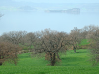
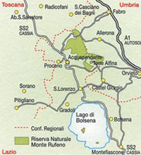
| La Selva del Lamone and Mezzano Lake |
|||||||||||
|
|
||||||||||
| The brigands’ path which is a tourist itinerary carried through with the GAL and the Comunità Montana Alta Tuscia Laziale funds, involving the whole territory of Northern Tuscia: from the northern Acquapendente borderline to the Castle of Vulci, in Canino. The path crosses the most valuable areas under a naturalistic and historical point of view: the lakes of Bolsena and Mezzano, the Nature Reserves of Monte Rufeno and Lamone Forest, the Etruscan necropolis of Pianezze in Grotte di Castro, another one in Castro and of Vulci, and the Francigena Road. This is the terroritory where brigands, hated and admired at the same time, blustered for a long time becoming almost a legend. The Maremma brigands’ raids of the end of 19th century are the underlying theme of the path but is also a further occasion to visit and to discover northern Tuscia. Il Sentiero dei Briganti: la guida | The brigands’path: guide | pdf |
|||||||||||
| Castel Viscardo | Castel Viscardo, which lies 13 km from Orvieto was developed around the Castello dei Duchi di Montevecchio. Of particular interest are the old kilns right outside the inhabited center, one of the few places where hand-made bricks and tiles are still produced. By its very nature this production is limited and the products are in great demand. Of the four hamlets which belong to the commune, Monterubiaglio and Viceno both grew up around medieval fortresses. The other hamlets are Le Prese and Pianolungo. |
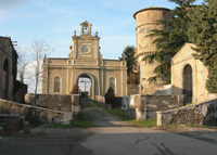 Castel Viscardo |
|||||||||
| Orvieto | Orvieto still preserves its charming Medieval character, thanks to its location and to its Etruscan roots, dating back to 9th century BC. Located on a plateau of volcanic tuff, Orvieto is surrounded by a stupendous landscape of fields and vineyards; the unbreachable walls appear to encircle the city rather than elevate it, as though it were a fortress rising on the flat valley floor of the river Paglia. The Duomo of Orvieto is one of the most important examples of Gothic architecture in Italy. The facade, a great triptych built by Lorenzo Maitani in the first years of the 14th century, is richly decorated in a dazzling mixture of polychrome marble, sculptures and mosaics, is certainly the prime masterpiece of Italian decorative Gothic. Inside the cathedral, the Chapel of San Brizio is frescoed by Fra Angelico andLuca Signorelli. |
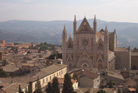 Orvieto, Duomo |
|||||||||
| Acquapendente | Acquapendente rises on the Francigena way, an important road that allowed the small town to grow up. It takes 8 days to complete the final stage in Lazio. The route passes by Acquapendente formerly known as Acquapendentem, meaning, pending water, to arrive at Bolsena. Acquapendente is part of the upper portion of Tuscia, bordering Tuscany and Umbria. The most significant monument is the cathedral of Santo Sepolcro, constructed around the year 1000 over the votive chapel that Matilda of Westphalia ordered built with the same dimensions as Christ's sepulchre. The municipalities of the towns of Acquapendente and Bolsena (located at the border between Latium and Tuscany) have restored (for pedestrians only) the old Via Cassia where it diverges from the current one. Via Francigena walks have become very popular among the residents and the many foreigners who live in the area. Walking in Tuscany | From Acquapendente to Bolsena | 22.1 km, 05:55 hours | Map The Monte Rufeno Natural Reserve, established in 1983, is part of the protected areas system of Lazio. It covers a surface of 2.892 hectares in, at the border with Umbria and Tuscany. The Selva di Meana Park is adjacent to the Natural Reserve of Mount Rufero of which it repeats the environmental characteristics. The poorly inhabited territory is crossed by many marked and scheduled nature walks. Among these, the Anello di Allerona (Allerona Ring) which crosses the entire territory of the park. Walking in Tuscany and Lazio | I Sentieri di Monte Rufeno |
 Monte Rufeno |
|||||||||
| Cività di Bagnoregio | Civita di Bagnoregio is a small hill town in the province of Viterbo. |
|
|||||||||
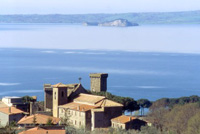
Lago di Bolsena |
Lake Bolsena, lies 100 kms north of Romein a relatively undiscovered part of Italy. The largest volcanic lake in Italy, Bolsena's deep waters are exceptionally clean and sustain a thriving fishing community. Bolsena is the principal tourist centre on the lake's shores. The old town, founded by the Etruscans, is dominated by the Monaldeschi castle and its raised position affords lovely views of the lake from its squares and medieval streets. Lake Bolsena is surrounded by a 37-mile long panoramic road that connects Bolsena, Montefiascone, Marta, Capodimonte, and Valentano. Marta, just a few miles south of Capodimonte, retains a very nice coat of arms of Paulus III at the entrance of the little town. A little fortress protects the town. In the midst of the lake, accessible by boat taxi, their are two privately owned islands, one (Isola Martana) is closed to the public, but the other (Isola Bisentina), which used to be a summer residence of the Popes, is open. There is a large church and monastery on the island and are several chapels, including one whose interior contains some frescoes possibly by Benozzo Gozzoli, lining its shores. Latera is located in the fascinating and enchanting territory of the Bolsena Lake, facing the western shores and extremely close to the famous Mezzano Lake. Bolsena is crossed by Via Cassia, the ancient Roman road which during the Middle Ages became known as Via Francigena. Walking in Tuscany | Walking around Lago di Bolsena Walking in Tuscany | From Bolsena to Montefiascone | 18.3 km, 05:17 hours | Map
|
|
|||||||||
| Viterbo is famous as the town of the Popes: the Popes had a country residence there, which may still be seen; and it thus became the site of important church councils, and in particular of the first conclave. Its beautiful historical center was conceived in the Middle Ages and preserves the essential style of the medieval architecture of central Italy, with many palaces. Celleno is located in the eastern part of the Tuscia area of Viterbo. The old village lays on a 476-metres-high green hill on which you can notice a fascinating medieval castle, Castello Orsini. Also in Celleno you can visit the medieval abbey and church rich in artistic masterpieces. Walking in Tuscany | From Montefiascone to Viterbo | 17.8 km, 04:38 hours| Map |
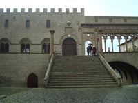 Viterbo |
||||||||||
| Bomarzo | Bomarzo is a small town, located near Viterbo on the road to Orta. The Castle, Palazzo Orsini di Bomarzo rises at the edge of this small town. Bomarzo Park, a 16th century villa with grotesque stone sculptures of monstrous porportions, depiciting mythological personalities and creatures taken from classical fables: Pergasus, Hercules, Neptune, Cera. Prince Pier Francesco Orsini built the villa in 1552. Mourning the death of his wife, Giulia Farnese, he erected a temple and stauary in her honor on the grounds. Vicino Orsini didn't call this garden a giardino, but Bosco Sacro, a Sacred Grove or Bosco dei Monstri, the Monsters' grove. Monster must be understood in the Latin meaning of monstrare, which means to show and demonstrate. This then means that from stop to stop, from stage to stage, each element is a component of an immense, very neoplatonic poem to his lost love. The villa was designed by Architect Pirro Ligorio. Giovanni Bettini purchased the property in 1954, eventually opening it to the public. During the nineteenth century and deep into the twentieth the garden became overgrown and neglected, but in the 1970s a program of restoration was implemented by the Bettini family, and today the garden, which remains private property, is a major tourist attraction. |
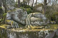 Il parco dei Mostri di Bomarzo |
|||||||||
| Tarquinia | Tarquinia, a medieval town famous for its archeological remains, is situated just a few kilometres from Tuscany, in Northern Lazio, very close to Capalbio and Monte Argentario and less than 1,5 hour drive from Podere Santa Pia. Tarquinia is custodian of an incredible number of treasures, including very old constructions, ancient palazzi and historic churches, all of which serve as an extraordinary testimony to the past of this town. Tarquiniais the Etruscan town per excellence. The frescoed walls of its tombs, famed throughout the world, are covered with the most archaic painting of the italic civilisation. The necropolis of Tarquinia, also known as Monterozzi, contains 6000 tombs, 60 of which include wall paintings. Tarquinia Etruscan Museum, housed in Palazzo Vitelleschi, is very likely the most important Etruscan Museum in the world. |
 Tarquinia, Santa Maria in Castello |
|||||||||
| Tuscania Vulci Lago Pellicone |
Tuscania is one of the loveliest towns in Upper Lazio. Built on a hilltop by the Etruscans in the 7th century BC, the town was situated in the river Marta valley, about 10 miles from Viterbo. Vulci, Tarquinia and Tuscania represent the emblems of Etruscan civilization. The ancient city Tuscania was a prosperous Etruscan centre in the 3rd century bc, and Etruscan tombs have been found nearby. In the Medieval historical center the beautiful Roman basilica of San Pietro stands on the old Etruscan acropolis, and has a 13th century façade with symbols of the Evangelists. The basilica, one of the most magnificent monuments in the Viterbo area, probably dates to the eighth century. The interior has massive 11th century columns with beautiful capitals and decorative pavings. At the foot of the hill stands the church of Santa Maria Maggiore, built during the same period as the church of San Pietro. Vulci | Castello della Badia Walking in Tuscany | Vulci |
 Tuscania |
|||||||||
|
|||||||||||
 |
|||||||||||
| Cosa | |||||||||||
Trekking | Walking in Southern Tuscany |
|||||||||||
|
|||||||||||
|
|||||||||||
 |
|||||||||||
|
|||||||||||