Abbadia San Salvatore

Abbey of Sant'Antimo

Albarese

Acquapendente


anghiari

Archipelago Toscano


Arcidosso


Arezzo


Asciano


Badia di Coltibuono


Bagno Vignoni

Barberino Val d'Elsa

Beaches

Bolsena Lake


Bomarzo

Brunello di Montalcino

Buonconvento

Campagnatico


Capalbio


Castel del Piano


Castelfiorentino

Castell'Azarra

Castellina in Chianti


Castelmuzio


Castelnuovo Bererdenga


Castiglioncello Bandini


Castiglione della Pescaia


Castiglione d'Orcia


Castiglion Fiorentino


Celleno


Certaldo


Chinaciano Terme


Chianti


Chiusi


Cinigiano


Città di Castello

CivitÀ di Bagnoregio


Colle Val d'Elsa


Cortona


Crete Senesi


Diaccia Botrona

Isola d'Elba

Firenze


Follonica


Gaiole in Chianti


Gavorrano

Gerfalco


Greve in Chianti


Grosseto


Lago Trasimeno


La Foce


Manciano


Maremma


Massa Marittima


Montagnola Senese


Montalcino


Monte Amiata


Monte Argentario

montecalvello

Montefalco


Montemassi


Montemerano


Monte Oliveto Maggiore


Montepulciano


Monteriggioni


Monticchiello


Monticiano


Orbetello


Orvieto


Paganico


Parco Naturale della Maremma


Perugia


Piancastagnaio


Pienza


Pisa


Pitigliano

Prato

Radda in Chianti


Roccalbegna


Roccastrada


San Bruzio


San Casciano dei Bagni


San Galgano


San Gimignano


San Giovanni d'Asso


San Quirico d'Orcia


Sansepolcro


Santa Fiora


Sant'Antimo


Sarteano


Saturnia


Scansano


Scarlino


Seggiano


Siena


Sinalunga


Sorano


Sovana


Sovicille

Talamone

Tarquinia


Tavernelle Val di Pesa


Torrita di Siena


Trequanda


Tuscania


Umbria


Val d'Elsa


Val di Merse


Val d'Orcia


Valle d'Ombrone


Vetulonia


Viterbo

Volterra


Traveling in Tuscany
             
 
Civita di Bagnoregio, is noted for its striking position atop a plateau of friable volcanic tuff overlooking the Tiber river valley, in constant danger of destruction as its edges fall off, leaving the buildings built on the plateau to crumble.

N L      I T

Civita di Bagnoregio [1]

Civita di Bagnoregio is only accessible via a pedestrian bridge built of reinforced concrete in 1965. The bridge can be crossed only on foot.


Surroundings


Cività di Bagnoregio


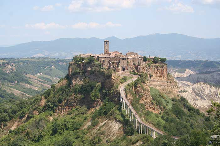
Civita di Bagnoregio, la città che muore located in a vast canyon atop a pinnacle ruled by wind and erosion. Perched on top of a hill among the valleys formed by Chiaro and Torbido streams, Civita appears clinged to the edge of a cliff where it dominates the wide desolated valley made up of calanchi. This isolation is the result of a continuous erosion that makes the tufa rock becoming thinner and thinner, the rock upon which Bagnoregio was built rests on layers of clay which over time tend to slip downwards, thus determining the collapse of sections of the rock above them. This explains why it is called il paese che muore, the dying town.

Civita is connected to the town of Bagnoregio by a narrow pedestrian bridge. The original bridge that connected these two villages eroded away over the centuries and was bombed out during WWII. In 1965 a new bridge was built for local foot traffic- si va a piedi. The walk is long but the view is spectacular! You enter the town through an archway, Santa Maria gate, cut in the rock made by Etruscans 2.500 years ago. This was once the main Etruscan road leading to the Tiber Valley and Rome

.

Civita di Bagnoregio

Civita di Bagnoregio is a magical place and poetically it’s known as the dying town. It was built built about 2,500 years ago by the Etruscans [1]

.

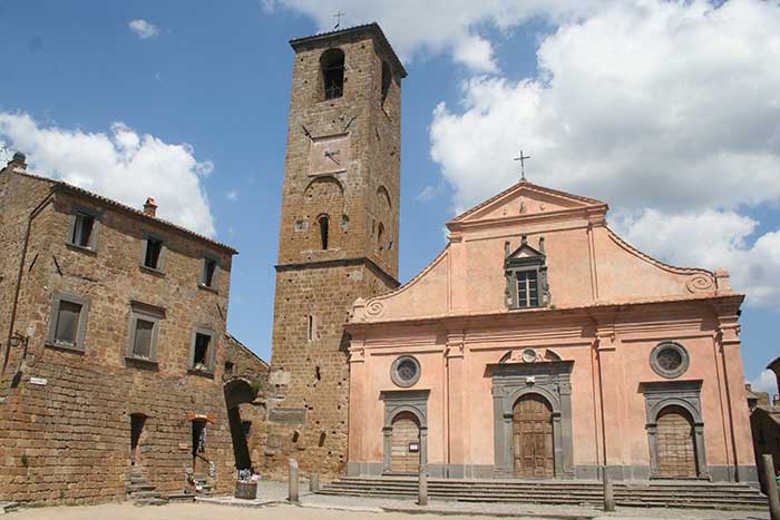
The gate is also known as Porta del Cassero which indicates it was part of lost fortifications. The statues of lions holding a human head which decorate it are medieval representations of the Church and were usually placed at the entrance of a church. Lions and eagles were among the most popular iconographic symbols of the Classical World and they continued to be popular during the Middle Ages.

Soon you will find yourself in Piazza San Donato or Piazza del Duomo. Nearby the Chiesa San Donato (8th century – the only church in town, built upon a pagan temple) there is a Romanesque bell tower or campanile (8th century) and the, now a government building. The church of San Donato was the cathedral of Bagnoregio until 1699, when this role was assigned to a new church built in the safer area where most of the inhabitants had moved. It has an elegant Renaissance façade while the interior is medieval.
Near the church there is a wine cellar and an olive press that dates back to Etruscan times.

  Civita di Bagnoregio, Porta S. Maria and the statues which decorate it
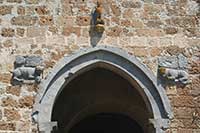
Civita di Bagnoregio, Porta S. Maria and the statues which decorate it.
     
Bagnoregio

Bagnoregio is located between Orvieto and Bolsena, at the boundary of Latium. The Neolitic village was the abode of the Etruscan and Roman civilizations that gave it honour and fame. Some finds seem to testify that the first settlements date back actually to a pre-Etruscan age. In the past it was sacked several times, by the Visigoths, the Goths, the Longobards and the Bysantines. In 600 it was already a bishops seat.
The St. Augustines church dates back to the period which goes from the XI to the XIV century. The bell tower of successive age, dating back to 1735. The church in fact keeps unchanged the characteristics of the Romanesque style in which it was built. It is rich in tablets and frescos.

The San Bonaventura Church, designed by the architect Pietro Gagliardi, was built in 1862 on the remains of an old building. It is characteristic for the Greek-cross plan and the Neoclassic dome.


The cathedral

It rose from the ruins of a very old church, according to some historians it dates back actually to 440 and in the past was dedicated to the Madonna della Neve. Inside there is a XII century parchment bible, jealously kept, that probably belonged to San Bonaventura.


The church of San Donato, which overlooks the main square [1]


Civita di Bagnoregio hosts the Palio della Tonna (donkey races) on the first Sunday in June and the second Sunday of September.

In Bagnoregio
Market day is Monday morning.


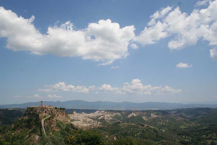
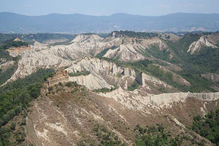
The village of Lubriano is right on the border of Southern Umbria. As you enter Lubriano from the main road, (where all the tour buses stop to gaze across at Civita) there is a small square, protected by chestnut trees. There is a small fountain, an exellent view over the Calanchi valley, and a small war memorial in the middle. The square is called the Col di Lana, the Square of the Wool. The sheep from the valley were assembled here for shearing.

Calanchi valley

View from Civita Bagnoregio on  Calanchi Valley [1]


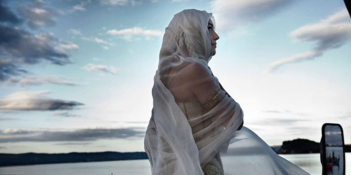
Lazzaro Felice

In 2018, Alice Rorhwacher filmed in the Valle dei Calanchi - Bagnoregio (Viterbo)

Winner of Best Screenplay at 2018 Cannes Film Festival, Alice Rohrwacher’s Happy as Lazzaro follows the adventures of a man living on the margins of his society who can seemingly travel through time. Alice Rohrwacher's mesmerizing new film, takes place in a rugged landscape somewhere in central Italy. In a valley called Inviolata, a desolate land of semi-arid steppe, lonesome rims and mesas, rough hills and dunes, a clan of tireless (but not joyless!) sharecroppers live, love, and labor under the strident thumb of an unforgiving marquis. Lazzaro is a worker on the farm who dutifully follows every command given to him by the Marchioness, her son, Tancredi, and the estate manager.
"Happy as Lazzaro uses a friendship's ups and downs as a satisfyingly expansive canvas for a picture rich with thematic and cinematic depth."[2]
Happy as Lazzaro is a magical neorealist fable, loosely inspired by the fairytale Francesco e il lupo by Chiara Frugoni.


Alice Rorhwacher, Lazzaro Felice, 2018


Channelling the spirit of Pasolini, Rohrwacher’s fascinating tale casts an ethereal, wondrous spell, and confirms her status as one of the most inventive and compelling voices in contemporary Italian cinema with this utterly transporting film experience [3].
Antonio Gramsci said: “What is necessary is pessimism of the intellect and optimism of the will”. That gets very close to my character" says Alice Rohrwacher.
The film consists of two fundamentally different sections: one rural, the other urban; one summary and dry, the other wintry and wet; one located in the recent past the other in our present. (...)
Alice Rohrwacher: 'From the very beginning, I conceived Lazarro Felice as a diptych. I had this idea about a memory of the past and memories of the future. The fracture in Lazarro’s story, his collapse, represents the fracture that has taken place in my country, Italy'.[4]


http://happyaslazzaro.com.au © Palace Films 2019


Civita di Bagnoregio, Castel Cellesi en Vetriolo are part of Bagnoregio.


Enlarge map


Civita di Bagnoregio, is noted for its striking position atop a plateau of friable volcanic tuff overlooking the Tiber river valley, in constant danger of destruction as its edges fall off, leaving the buildings built on the plateau to crumble. For more information about this hidden treasure visit a web publication Accross the Bridge: A portrait of Civita di Bagnoregio by Carol Martin Wat.


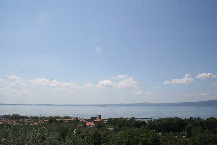
Bolsena Lake | Lago di Bolsena


Bolsena is crossed by Via Cassia, the ancient Roman road which during the Middle Ages became known as Via Francigena.
The stretch of Via Francigena from Bolsena to Montefiascone is a path that leads from Basilica of Santa Cristina in Bolsena (known for the miracle of Corpus Christi) to Rocca dei Papi in Montefiascone, for a total of about 18 km.
The main part of the path goes through olive groves, hills and woods and goes over some parts of the ancient Via Cassia, with wonderful views of the lake.
Upon arrival at the fortress Popes of Montefiascone you are greeted by a great 360 degrees view from the Tower of the Pilgrims: here you can see the gentle waters of Lake Bolsena

VF - 37 - From Acquapendente to Bolsena | 22.1 km, 05:55 hours

After a visit to the Church of Santo Sepolcro (its bright crypt was built in accordance with the church of the same name in the Holy Land) the route continues without problems till San Lorenzo Nuovo, where you can admire views of Lake Bolsena. Going down the volcanic crater, undertake a pleasant route along excavated streets leading to Bolsena, going up and down among olive groves, fields, and forests in the background. Road-houses and water only in San Lorenzo Nuovo.

VF - 38 - From Bolsena to Montefiascone | 18.3 km, 05:17 hours

Among olive groves and brushes the path detaches from Bolsena and, after going up and down, admiring wonderful sights of the lake, come back to the paving along the ancient Via Cassia. The 360 degree view from the Tower of Pilgrims in Montefiascone is exciting. Pay attention to traffic walking along the tracks between Croce del Pellegrino and Ponte della Regina, Cassia Main Road till Poggio Lungo. Water supply only in the first section of the route.

Montefiascone

Church of Santa Maria di Castell

The small church of Santa Maria di Castello, also known as Madonna of the Snow, stands near the Rocca dei Papi (Papal Fortress). According to tradition, Pope Innocent the 3rd had it built during his 1207 visit to Montefiascone, to provide the Fortress with a Palatine church. The building originally had a nave and two aisles separated by pillars, whereas the current layout is the result of massive work done during the 19th century, when most of the dilapidated ancient structures were knocked down; only the presbytery, readapted to the church we see today, was spared. Inside, the niche to the left of the altar hosts an original fresco of the Madonna on the throne with Child and four saints and the commissioner, early 14th century.

Church of San Flaviano

The relics of the martyr Flaviano, killed in 361 during the persecutions of Giuliano l’Apostata, are kept in the church of San Flaviano a Montefiascone. The present building was built between the 12th and 14th centuries and rises on the site of an older church dedicated to the Virgin.

We enter the lower church, whose architecture is very complex, from the main façade. As a matter of fact, its front part is composed of an avant-corps with a nave and two aisles, beyond which the central nave reaches the upper church, while the aisles maintain the same height. Three apses open on the back wall; the side ones have a curious oblique position due to the previous layout of the building, quite probably polygonal or octagonal.

There are four chapels on the left aisle; the third chapel hosts the tomb that tradition identifies with that of Bishop Johannes Defuk who, according to legend, gave the name Est! Est!! Est!!! to Montefiascone's white wine and who died from drinking too much of it.
The walls of the lower church are covered almost entirely with frescoes, datable between the 14th and 16th centuries.
A staircase at the end of the right aisle leads to the upper church. This church also has a nave and two aisles, separated by pillars and columns on which arches rest; the two toward the façade are of extraordinary width and belong to the early 14th century phase. The floor at the centre of the central nave opens onto the lower church. The apses are missing; the so-called Chair of Urban the 4th, opposite of which is the altar, is found on the back wall (actually here western counter-façade).
The village of San Flaviano developed around the church. Sigerico stopped here during his return trip from Rome to Canterbury, recording the place in his journal with the name Sancte Flaviane. Already flourishing in the 9th century, it was destroyed in 1187 by the Viterbesi (inhabitants of Viterbo) and never rebuilt.

Other places of interest are the Church of Saint Francis, the Church of Sant’Andrea in Campo, the Church of Santa Maria di Castello, the Cathedral of Saint Margaret and the Fortress of the Popes.

[Source: Via Francigena in Lazio | www.francigenalazio.it/en]


Via Francigena nel Lazio | Map and route details | www.francigenalazio.it

Holiday accomodation | Podere Santa Pia, hidden in the valley between Castiglioncello Bandini and Cinigiano


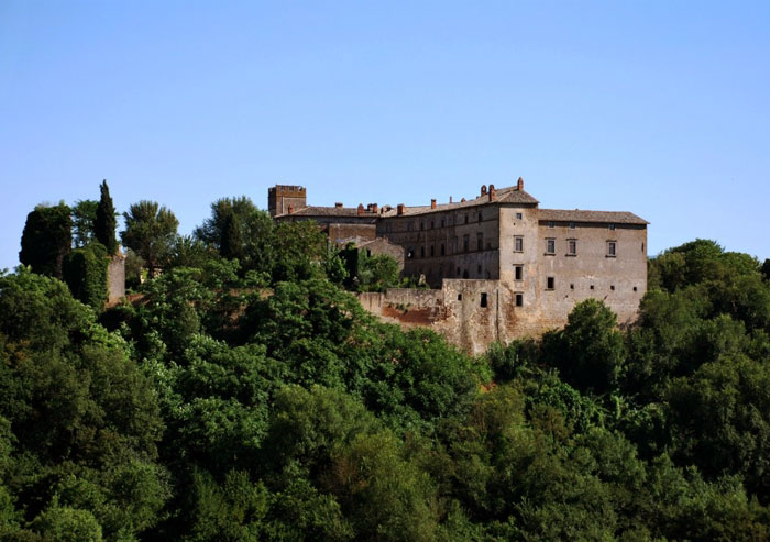
The Bisentina isle is an interesting touristic excursion for those people who go to Capodimonte on the Bolsena lake. Between the village and the isle there a ferryboat's service more than once a day on condition to have a minimum number of passengers.

The etruscan and roman left a few traces of its permanence on the isle. In the IX century the coastal populations took to it to escape to the saracen's raids. In the middle of 1200 became property of the Bisenzio family who then burnt it out because of some disputes with the inhabitants. In 1261 Pope Urbano IV conquerred the isle again, in 1333 Ludovico il Bavaro, accused of heresy and excommunicated by the Pope, destroyed it again. From 1400 it was property of the Farnese family and it had a period of prosperity. It was visited by numerous Popes. In 1635 it was governed by Castro's duke Odoardo Farnese who went to clash to the church which ended with the fully Castro's destruction. After that, the Bisentina isle, like the Martana, went back to the church and then gived up. The princess Beatrice Spada Potenziani, wife of the duke Fieschi Ravaschieri, is the present proprietress.

Le Meraviglie (Alice Rohrwachter, 2014) is a magical realist portrait of a family of beekeepers in rural Italy. The film, which stars Monica Bellucci, was shot in Sorano and other areas of the province of Grosseto, in the town Bagni San Filippo and on Isola Bisentina.


Castello di Montecalvello


Bisentina, Chiesa di Santi Giacomo and Cristoforo

Monoca Bellucci on Bolsano Lake

Montecalvello, which rises around a castle where the famous Balthus, a contemporary painter, lived for thirty years.
Restored by Count Balthus Klossowski de Rola, the castle is beautifully maintained and still evolving .The studio of Balthus still has canvases on easels and a table where the artist worked.


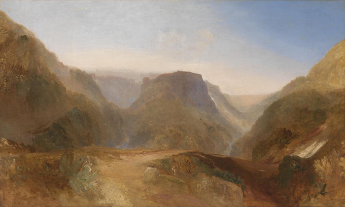
William Turner in Civita di Bagnoregio, 1828


Joseph Mallord William Turner ‘Italian Landscape, probably Civita di Bagnoregio’, 1828

Joseph Mallord William Turner ‘Italian Landscape, probably Civita di Bagnoregio’, 1828

Art in Tuscany

During his second trip to Rome in 1828, Turner spent some weeks painting in a studio, the first and only time he seems to have done so in a foreign country. This impressive, but unfinished, canvas appears to date from that period. Sketches documenting his route south between Florence and Rome suggest that the location is somewhere near the town of Orvieto, possibly Civita di Bagnoregio. There is a freshness and vitality about the lush green hills and distant waterfall, although the artist would have added a far greater level of detail to the work before declaring it complete. 


[1] Photo by© Traveling in Tuscany, all rights reserved | www.travelingintuscany.com
[2] "Happy as Lazzaro (Lazzaro felice) (2018)"Rotten Tomatoes. Fandango Media. Retrieved 27 April 2019.
[3] Source Palace Films 2019 | www.youtube.com

[4] Interview with Alice Rohrwacher | rm.coe.int/interview-with-alice-rohrwacher