Abbadia San Salvatore

Abbey of Sant'Antimo

Albarese

Acquapendente


anghiari

Archipelago Toscano


Arcidosso


Arezzo


Asciano


Badia di Coltibuono


Bagno Vignoni

Barberino Val d'Elsa

Beaches

Bolsena Lake


Bomarzo

Brunello di Montalcino

BuOnconvento

Campagnatico


Capalbio


Castel del Piano


Castelfiorentino

Castell'Azzara

Castellina in Chianti


Castelmuzio


Castelnuovo Bererdenga


Castiglioncello Bandini


Castiglione della Pescaia


Castiglione d'Orcia


Castiglion Fiorentino


Celleno


Certaldo


Chinaciano Terme


Chianti


Chiusi


Cinigiano


Città di Castello

CivitÀ di Bagnoregio


Colle Val d'Elsa


Cortona


Crete Senesi


Diaccia Botrona

Isola d'Elba

Firenze


Follonica


Gaiole in Chianti


Gavorrano

Gerfalco


Greve in Chianti


Grosseto


Lago Trasimeno


La Foce


Manciano


Maremma


Massa Marittima


Montagnola Senese


Montalcino


Monte Amiata


Monte Argentario

montecalvello

Montefalco


Montemassi


Montemerano


Monte Oliveto Maggiore


Montepulciano


Monteriggioni


Monticchiello


Monticiano


Orbetello


Orvieto


Paganico


Parco Naturale della Maremma


Perugia


Piancastagnaio


Pienza


Pisa


Pitigliano

Prato

Radda in Chianti


Roccalbegna


Roccastrada


San Bruzio


San Casciano dei Bagni


San Galgano


San Gimignano


San Giovanni d'Asso


San Quirico d'Orcia


Sansepolcro


Santa Fiora


Sant'Antimo


Sarteano


Saturnia


Scansano


Scarlino


Seggiano


Siena


Sinalunga


Sorano


Sovana


Sovicille

Talamone

Tarquinia


Tavernelle Val di Pesa


Torrita di Siena


Trequanda


Tuscania


Umbria


Val d'Elsa


Val di Merse


Val d'Orcia


Valle d'Ombrone


Vetulonia


Viterbo

Volterra


Walking in Tuscany
             
 
Roccatedereghi

Roccatederighi


Walking trails in Tuscany Surroundings


5Regoni - Sassoforte - Sassofortino - Roccatederighi


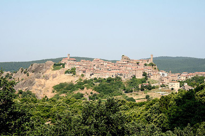
The territory of Roccatederighi


The itinerary


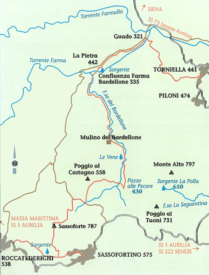
Map Torniella Regoni

Map Torniella Regoni


Development: km 19,8 | Time 7.35 hours
Interests | Archaeological (Sassoforte Castle) | Geological (La Pietra-Outcrop of Rhyolite in Sassoforte) | Botanical (Chestnut wood-
Turkey wood-riparian vegetation along the Bardellone Torrent-Beech trees in Sassoforte) | Faunal (Wild boar-Roe deer-Hawks) |
Landscape (on the top of Sassoforte-La Pietra)

Practicability
Difficult because of its length and the part that goes up to Sassoforte, it runs for almost its entire length
along paths through forest and chestnut wood. It is practicable in every season and water can be fetched
along the trail.


On leaving Torniella, after having gone through a chestnut tree wood we get to an old farm called "La Pieve". Walking on the road that goes down through a turkey oaks wood, we reach the Farma and we have to cross. If it has recently rained and the water level is too high, we can walk along the fields’ edges and through a hundred metres of wood and then get to the bridge of the road no 73, Senese-Aretina. To get back to our itinerary, left the bridge we walk on for about 1 km where we turn left on a unpaved road; on the right there is a farm called Santa Sicutera. After about 300 metres the road wades the Farmulla torrent and after other 300 hundred metres, we find the path, fording height, at the opposite side of the torrent's ank. Keeping left, walking on the unpaved road, we get to a small disused jasper quarry, just below a rock spur called "La Pietra", which gives the name to a small Natural Reserve between the Farma and Farmulla torrents, from here we get a wonderful view of the Bardellone valley and Monte Alto. We can admire a large wooded area ,which gives the best of itself in autumn thanks to the colours of the leaves :it is a vast area characterised by heterogeneous coppice wood, thick and intricate under wood of shrubs, a perfect environment for wild boar , which is widely hunted here. Hunting is practised during winter. Sometimes hunters get involved in shooting accidents but dogs are more at risk: they very often get attacked by wild animals and get seriously wounded.

Just before getting to the Farma, we find a spring, once surrounded by secular alders.

We walk on, crossing the Farma by the Bardellone bank, for a long way. It is a pleasant environment, in spring it is full of flowers such as primroses and violets that embellish a wood of poplars, alders, maples, turkey oaks, hornbeams, and beeches. We walk near the ruins of an old mill and some spring waters called "Le Vene".
We get to a pond named "Pozzo alle Pecore", we keep on walking through "Poggio del Castagno" to get to Sassoforte. We take the road that starts from a farm (called Poggio al Castagno itself) and we then get to another road that can be a short cut (if taken eastward) to arrive in Sassoforte (2 km) without following the marked indications. We then enter the chestnut wood of Sassoforte with its secular trees, among huge rocks and striking sheer walls. And after the final ascent, we find ourselves on a plateau where imposing beech trees grow. Here there are the ruins of Sassoforte Castle, an impressive strong hold destroyed by the Republic of Siena in the fifteen century. We then walk down on a path which goes through a coppiced wood and part of a chestnut wood , as far as the panoramic road of San Martino to find the indication of our Trekking: turning right we arrive in Roccatederighi, turning left, in Sassofortino.[1]


Sassofortino


Walking in Tuscany

Massa Marittima and the Metalliferous Hills


Trekking in and around Roccastrada

Sticciano - Roccastrada | 19 km, 5 hours

Roccastrada - Castello del Belagaio | 13,5 km, 4,5 hours

Castello del Belagaio - Torniella | 13 km, 4 hours

Torniella - Sassoforte - Roccatederighi | 20 km, 5 hours

Piloni - Sassoforte - Sassofortino - Roccatederighi | 16 km, 6 hours

Sassofortino - Montemassi | 13 km, 4,5 hours

Roccatederighi - Montemassi | 7 km, 2,5 hours


Hiking trails in the Val di Merse

1. Sentiero Iesa-Tocchi

2. Sentiero Iesa-Terme di Petriolo

3. Sentiero della Gola del Merse

4. Sentiero di San Galgano

5. Sentiero della Pietra

6. Sentiero Scalvaia-Valle del Farma

7. Sentiero Monticiano-Camerata


Trekking | Walking in Southern Tuscany

Walking in Tuscany | Nature reserves and beaches in the Maremma

Walking in Tuscany | Itinerary 6 | Farma Valley

Trekking in Toscana | Sentiero 6 | Scalvaia - Valle del Farma

Maps | Multigraphic – Tourist road map 1:50,000 - Maremma


[1] Source: Breve Guida Trekking Roccastrada | www.comune.roccastrada.gr.it


Bibliography

Aldo Mazzolai, Guida della Maremma. Percorsi tra arte e natura, Le Lettere Firenze, 1997.

Giuseppe Guerrini, a cura di (Amministrazione Provinciale di Grosseto) Torri e Castelli della provincia di Grosseto, Nuova Immagine Editrice Siena, 1999.


Hidden secrets in Southern Tuscany | Podere Santa Pia


Podere Santa Pia, view on the valley below