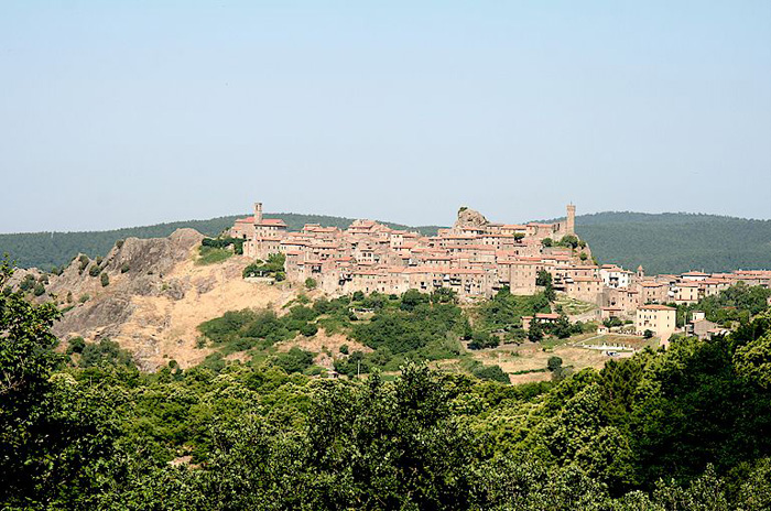
Abbadia San Salvatore

Abbey of Sant'Antimo

Albarese

Acquapendente


anghiari

Archipelago Toscano


Arcidosso


Arezzo


Asciano


Badia di Coltibuono


Bagno Vignoni

Barberino Val d'Elsa

Beaches

Bolsena Lake


Bomarzo

Brunello di Montalcino

BuOnconvento

Campagnatico


Capalbio


Castel del Piano


Castelfiorentino

Castell'Azzara

Castellina in Chianti


Castelmuzio


Castelnuovo Bererdenga


Castiglioncello Bandini


Castiglione della Pescaia


Castiglione d'Orcia


Castiglion Fiorentino


Celleno


Certaldo


Chinaciano Terme


Chianti


Chiusi


Cinigiano


Città di Castello

CivitÀ di Bagnoregio


Colle Val d'Elsa


Cortona


Crete Senesi


Diaccia Botrona

Isola d'Elba

Firenze


Follonica


Gaiole in Chianti


Gavorrano

Gerfalco


Greve in Chianti


Grosseto


Lago Trasimeno


La Foce


Manciano


Maremma


Massa Marittima


Montagnola Senese


Montalcino


Monte Amiata


Monte Argentario

montecalvello

Montefalco


Montemassi


Montemerano


Monte Oliveto Maggiore


Montepulciano


Monteriggioni


Monticchiello


Monticiano


Orbetello


Orvieto


Paganico


Parco Naturale della Maremma


Perugia


Piancastagnaio


Pienza


Pisa


Pitigliano

Prato

Radda in Chianti


Roccalbegna


Roccastrada


San Bruzio


San Casciano dei Bagni


San Galgano


San Gimignano


San Giovanni d'Asso


San Quirico d'Orcia


Sansepolcro


Santa Fiora


Sant'Antimo


Sarteano


Saturnia


Scansano


Scarlino


Seggiano


Siena


Sinalunga


Sorano


Sovana


Sovicille

Talamone

Tarquinia


Tavernelle Val di Pesa


Torrita di Siena


Trequanda


Tuscania


Umbria


Val d'Elsa


Val di Merse


Val d'Orcia


Valle d'Ombrone


Vetulonia


Viterbo

Volterra


Walking in Tuscany
             
 
Roccatedereghi

Roccatedereghi

Walking trails in Tuscany Surroundings


Itinerary Piloni e Torniella, Sassoforte e Sassofortino towards Roccatederighi


The itinerary


Map TFrom Da Piloni e Torniella, Sassoforte and Sassofortino to Roccatederighi

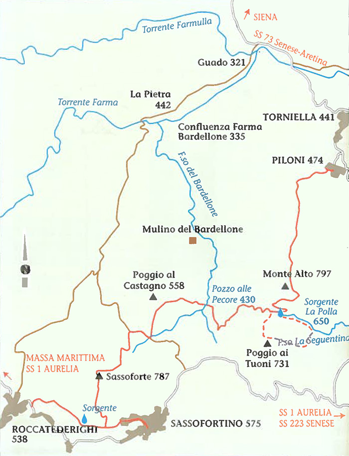
Map Torniella Regoni


Development km 15,7 | Time 7.5' hours
Interests | Archaeological (Sassoforte Castle) | Geological (Outcrop of Rhyolite in Sassoforte) | Botanical (Beech trees in Monte Alto and
Sassoforte - Yew trees in Monte Alto and along the Seguentina Torrent)
Practicability
If it is covered throughout its length, this route can be difficult. It runs through paths, woods, and it is
practicable in every season. Water can be fetched along the route.

We leave the hamlet of Piloni walking towards the old kaolin quarries and then through a abandoned cestnut wood which was once the solely sustain of the local economy. We arrive to Monte Alto (797 metres above the sea level), the highest mount of Roccastrada district. Atop we can notice a small tower built to sight fires. Between the northern and the southern side of Monte Alto there is sharp change in vegetation: chestnut and beech trees give way to turkey oak trees. We walk on to find a spring called "La Polla", towered by enormous beech trees, summer stopover for those who want to have a rest and drink its fresh water. The Seguentina torrent has its source here. Along these steep slopes, thanks to the peculiar climate of this narrow valley, grow a colony of yew trees. On the map there is an optional route that follows
the torrent, we then see a ditch on the right and in the middle of an open space, a beautiful yew majestically stands. To go back to the itinerary, we go up the ditch, and then we turn left when we get to the road.
Walking to the right we pass "Poggio ai Tuoni" and under a high voltage trellis. We walk through a wood of chestnut trees as far as a carriage way and from there to a gravel stone road, which is a short cut to Sassofortino (2 km). However, if we follow the trail, we get to the Bardellone torrent and then to the "Pozzo alle Pecore" pond: we are on the itinerary no 5, Regoni - Sassofortino.[1]


I Canaloni del Torrente Farma


Walking in Tuscany

Massa Marittima and the Metalliferous Hills


Trekking in and around Roccastrada

Sticciano - Roccastrada | 19 km, 5 hours

Roccastrada - Castello del Belagaio | 13,5 km, 4,5 hours

Castello del Belagaio - Torniella | 13 km, 4 hours

Torniella - Sassoforte - Roccatederighi | 20 km, 5 hours

Piloni - Sassoforte - Sassofortino - Roccatederighi | 16 km, 6 hours

Sassofortino - Montemassi | 13 km, 4,5 hours

Roccatederighi - Montemassi | 7 km, 2,5 hours


Hiking trails in the Val di Merse

1. Sentiero Iesa-Tocchi

2. Sentiero Iesa-Terme di Petriolo

3. Sentiero della Gola del Merse

4. Sentiero di San Galgano

5. Sentiero della Pietra

6. Sentiero Scalvaia-Valle del Farma

7. Sentiero Monticiano-Camerata


Trekking | Walking in Southern Tuscany

Walking in Tuscany | Nature reserves and beaches in the Maremma

Walking in Tuscany | Itinerary 6 | Farma Valley

Trekking in Toscana | Sentiero 6 | Scalvaia - Valle del Farma

Maps | Multigraphic – Tourist road map 1:50,000 - Maremma


[1] Source: Breve Guida Trekking Roccastrada | www.comune.roccastrada.gr.it


Holiday accomodation Tuscany

Hidden secrets in Tuscany | Podere Santa Pia