| |
|
 |

|
|
|
The Maremma is the perfect choice for the romantic traveller. It offers a mixture of ancient civilizations, enduring local traditions, lush landscapes and numerous nature reserves. All of this is accompanied by an outstanding culinary and wine-making tradition.
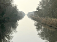
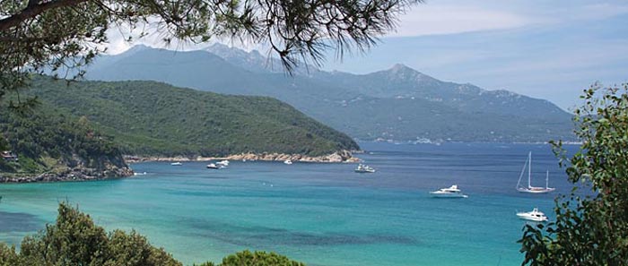
The coastal region of Tuscany stretches from the northern area dominated by Pisa to the southern area of Grosseto.
Once an unlucky area because it was a swamp and thus infested by malaria, it is now a prime example of pure and wild natural beauty due to its crystal waters, golden beaches, and a coast characterized by pine trees and populated with cows and select horses.
The coast itself offers gentle beaches, natural areas and hills for hiking, fishing villages, resort towns. There is an ancient legend of the birth of the Archipelago of Tuscany that says that when the Tyrrhenian Venus emerged from the sea, seven gemstones fell from her crown and formed thus the Islands of the Tuscan Archipelago.
The climate here is very mild; almond trees start blooming in February. Ancient Etruscan settlements and tombs dot the landscape and some of Tuscany’s most intriguing towns adorn the hilltops.
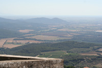
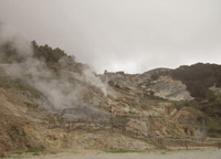
In the southwest of the Maremma is an area little known even by Italians, called the Metal Hills, the Colline Metallifere.
With only a few major urban centers, like the beautiful Massa Marittima, it is an area populated by fortified villages still preserving their medieval form. Between them lie dense woods and solitary valleys, against which rise the steep mountains that diminish only as one reaches the coast. On the littoral, marshes —salty, but fertile— constituted one major economic
resource. But the true treasure of this region is underground, where the earth is packed with major mineral resources: iron, copper, lead, and silver.
'Silver was the most precious mineral of the Middle Ages owing to the fact that, in the 8th century, Charlemagne decreed the switch from gold to silver coinage, a change which was adopted in 781 in his Italian kingdoms. Silver thus became the principal material for money coined in the mints located in the major Italian cities. From the 9th through the 13th centuries
this region, today isolated and far from the peninsula’s major communication networks, became one of the central places of medieval Italy.' [1]
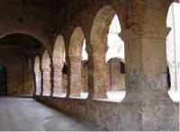
Massa Marittima is the historical capital of the mining territory of the
Metalliferous Hills. As of the medieval period, the wealth of minerals
extracted on its territory permitted the city to adorn itself with civil
and religious buildings that had nothing to envy of the greatest
centres of the epoch. Today, the local system of museums valorises the
artistic and scientific tokens of its glorious past.
Along the Etruscan coast, not far from Bibbiona, you’ll find the famous Viale dei Cipressi, immortalized by Giosuè Carducci in his well-loved poem Davanti a San Guido.
|
|
|
 |
|
|
|
|
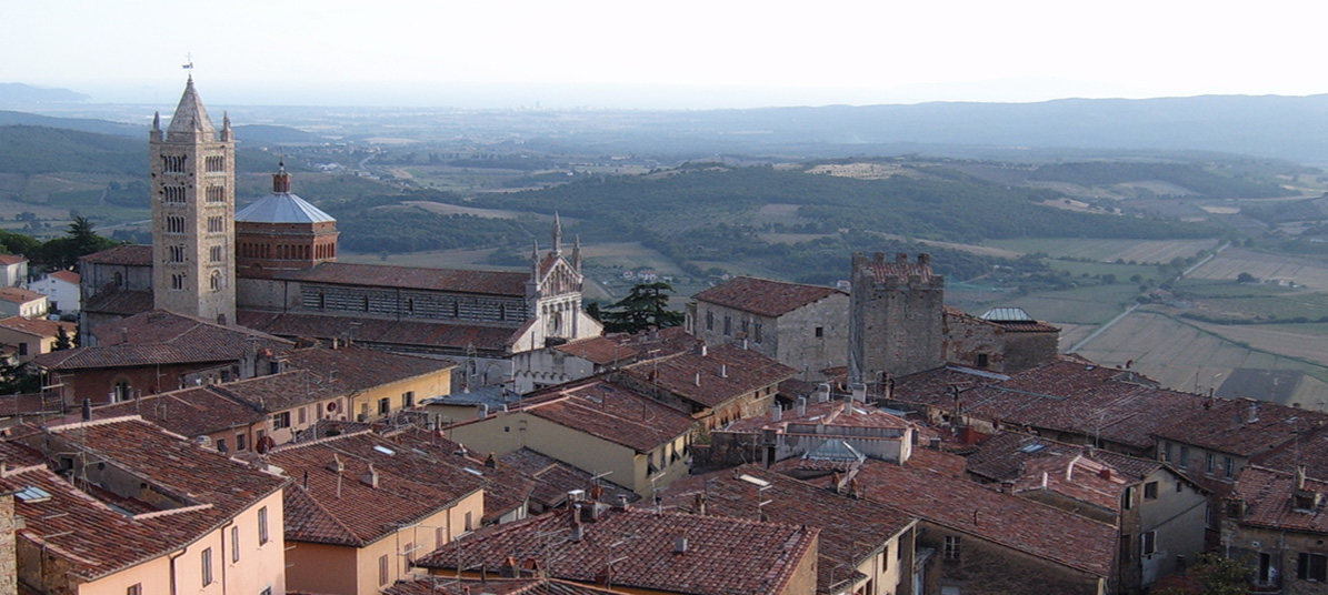
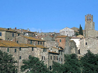
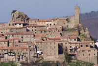
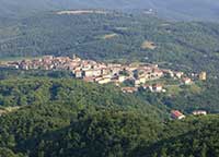
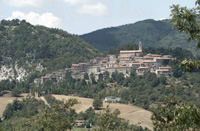
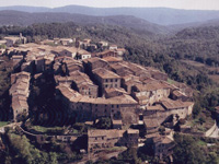
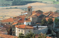
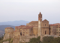
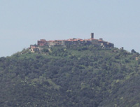
Massa Marrittima
|
| |
|
Massa Marittima and the Colline Metallifere, the Metalliferous Hills
|
| Massa Marittima |
|
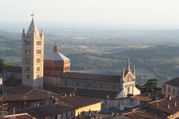
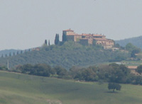
Massa Marittima lies in province of Grosseto, between Follonica en Siena and about 20 km from Follonica and the sea.
Massa Marittima is one among the most beautiful and picturesque Medieval towns of Tuscany.
The town dates back to the XII century a. C. when the Bishop of Populonia, while escaping from the coast and looking for a site protected by the external assaults but also rich of resources to exploit, chose the Monteregio hill, in the upper part of the town, in order to settle there his new residence. It’s not by chance that Massa Marittima got a key position in controlling the territory’s ore bodies, today known under the name of Metalliferous Hills.
Of probable Etruscan origin, the city conserve many monuments of its more prosperous period. The city is subdivided in three parts, the low part (or old city) where predominate the Romanesque style and the high part (or new) but founded in 13th and 14th centuries and the Borgo.
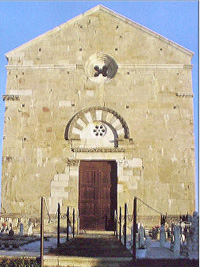
Piazza Garibaldi, considered one of the most mature examples of medieval urban Tuscany, where almost all of the major civil and ecclesiastical monuments stand out: the Duomo, one of the most refined sacred buildings of Tuscany, the Palazzo Pretorio and Palazzo Communale.
Located inside one of Massa Marittima’s main public fountains, the Fonte dell’Abbondanza, an intriguing work of art the “Tree of Fertility” was discovered in 1999. The painting by an unknown artist illustrates a tree from the branches of which are hanging dozens of very realistically drawn penises.
After a three-year restoration process, a 13th-century painting known as the “Tree of Fertility” has finally been unveiled, but the phalluses that once hung from the tree’s branches have vanished. Gabriele Galeotti, who called for a formal investigation after seeing the finished work, told UK newspaper The Telegraph that “many parts of the work seem to have been arbitrarily repainted. The authenticity of the fresco seems to have been compromised by a restoration effort that did not respect the original character of the work.”
In May, Massa Marittima celebrates the biannual Balestro del Girifalco (Falcon Crossbow Contest), one of the biggest and most impressive festivals in Southern Tuscany.
The Balestro del Girilalco was first held on 8 September 1402.
Map
|
|
 Duomo, dedicated to San Cerbone Duomo, dedicated to San Cerbone
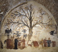
Tree of Fertility
|
| |
|
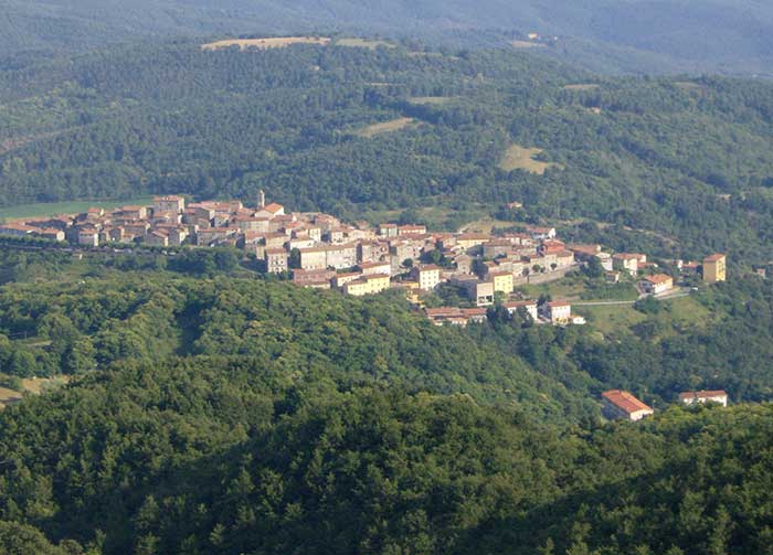
Parco Archeologico del Lago dell'Accesa
A natural addition to the city tour is a visit to the excavations of the mining village of Accesa, an ancient Etruscan centre located 10 km from Massa Marittima, which can be reached turning off the road for Gavorrano in the locality of Pesta.
In the midst of a dense woodland area near the Lago dell’Accesa, lie the remains of an ancient Etruscan town, which is still being excavated. The settlement, divided into quarters, was one of a series of small towns in the 6th century B.C. in the area of influence of Vetulonia, sited along itineraries tied to mining activities in the area. The dell’Accesa area is outstanding for having yielded copious evidence of what is today acknowledged as one of the few known urban centres of Etruria.[2]
In between Podere Santa Pia and Massa Marittima, Paganico and Campagnatico are well worth a visit.
|
|
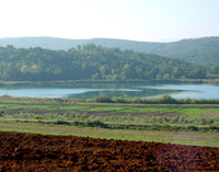
Lago dell'Accesa
|
|
|
Campagnatico is fascinating town in the Maremma, located in the south of Valle del’Ombrone, on the border of Tuscany’s newest up and coming wine area, the Montecucco DOCG.
The ancient area of Campagnatico is surrounded by walls and square towers.
Among the great architectural accomplishments of the 15th century is the Chiesa della Misericordia, still visible today. Of special historical and architectural interest is the Pieve di San Giovanni Battista, of Romanic-Gothic style, charcatherized by a vela, a bold bell tower. Inside the Pieve, frescoes of the late the 13th century. |
|
Campagnatico
|
| Civitella Paganico |
|
Paganico is an ancient fortified town built by the Sienese to protect the Ombrone valley and the access to the hills of Siena. The medieval walls are perfectly preserved and the apse of the Chiesa di San Michele Arcangelol houses beautiful frescoes by Biagio di Goro Ghezzi.
Comune
Civitella Marittima, Paganico, Casenovolo Casal di Pari and Pari belong to the municipality of Civitella Paganico. Bagni di Petriolo with the thermal spas Terme di Petriolo are nearby.
The hermal baths of Petriolo
The authentic thermal baths of Petriolo date back to 1230. Known already to the ancient Romans and mentioned by Ugolino of Montecatini in his Tractatus de Balneis for the therapeutic properties of its suphureous waters. In 1404 the fortification of Bagni di Petriolo was completed, the only remaining example of fortified thermal springs. The Baths of Petriolo were frequented by such illustrious figures as Pope Pius II Piccolomini and Lorenzo de' Medici.
|
|
|
| Casenovole |
|
Monte Antico and Castello di Casenovole
In the comune of Civitella Paganico, there are two other picturesque castles in a nice panoramic position: the Castle of Monte Antico and the Castle of Casenovole
Monte Antico is a small town at the base of a hill and it towers valle dell’Ombrone which twists slowly at the base of Monte Amiata. The origins of the castle "Castello di Monte Antico" date back to the 10th century. The castle is situated on the top of a hill, at the confluence of the rivers Orcia and Ombrone.
Going beyond Castello di Monte Antico you end up on a rough road leading Casal di Pari through bushes and cultivated fields. On your way, we highly recommend a stopover at Castello di Casenovole. A unique 13th century castle with exceptional views over the Ombrone valley. The castle is situated on the top of a hill, at the confluence of the rivers Orcia and Ombrone.
|
|
Castello di Casenovole, view from Civitella Marittima |
| |
|
|
|
|
| Roccastrada |
|
Roccastrada is a fairly ordinary place distinguished by the beautiful 13th century church of Saint Nicola in the old part of the town. The Town Hall, the Municipal Library and the Theatre of the Concordi are located in the 19th century new part of the town.
Roccastrada, a village in the heart of the province, is starting point of a wide net of more than 150 km pathways leading through this area full of natural beauty and historic locations. |
|
Roccastrada, view on the valley below
|
| Roccatederighi |
|
Roccatederighi is one the Maremma's most interesting medieval villages. The village of Roccatederighi is located on a spur with spectacular views over the plains of the Maremma below. Situated at an altitude of 538 m above sea level and hidden amidst gigantic rocks of rhyolite, called masses, its profile marked by towers and rooftops stands out perfectly against the surrounding nature and countryside.
The fortification La fortezza sits on the highest point of the village and while there remains little of the medieval walls, the tower has been restored. |
|
 Roccatederighi
|
| Montemassi |
|
The castle of Montemasi is, without any doubt, the most famous monument in the territory of Roccastrada, for its importance of historical document (it was represented on the famous fresco situated in the public palace of Siena attributed to Simone Martini) and for the high example of Gothic style architecture that it represents. |
|
|
| Torniella |
|
The little mediaeval town of Torniella, dating from the 11th C, is located in the Alta Maremma in the county of Roccastrada, among woods and forests on the border between the provinces of Siena and Grosseto. The castle of the Ardengheschi, the vassals of the Aldobrandeschi, forms the stronghold of the town.
|
|
|
| Prata |
|
In the frazione of Prata are a medieval castle with two towers and the Pieve of Santa Maria Assunta. The walled borough of Tatti includes the medieval church of San Sebastiano.
|
|
|
| Gerfalco |
|
The village of Gerfalco belongs to the municipality of Montieri. There is a well marked network of hiking trails. A wild-romantic path leads to the former silver mines, from where there is a wonderful view to the sea and over Maremma Tuscany.
Riserva Naturale Cornate e Fosini
The Reserve is situated in the west of the town of Chiusdino, in the eastern part of Colline Metallifere, and includes one of the few mountain areas of southern Tuscany.
Walk from Gerfalco to Castello di Fosini and the Poggio Mutti.
Other interesting villages in the area are Monterotondo Marittimo, completely immersed in the woods. Near the village, the medieval Sanctuary of Frassine is one of the few churches in the Maremma dedicated to the Holy Virgin.
|
|
Gerfalco
|
| Montieri |
|
|
|
 |
| |
|
|
|
|
| Monticiano |
|
Monticiano, a very old village which dates back to the 12th century, is located in a beautiful area, in the heart of a valley between the river Merse and the river Farma. The oldest part of the village is located on a hilltop, within the remains of the ancient walls. From the top of the hill the view over the valley of the river Merse is breathtaking.
The village has two churches, the Romanesque Chiesa di Sant'Agostino of the late 13th century, with baroque interiors andin the chapter room of the former monastery frescoes by Bartolo di Fredi, and the older parish Pieve dei Santi Giusto e Clemente, of the 12th century, with a neat stone façade.
Monticiano is only 5km away from the mysterious Abbey of San Galgano and the legendary sword in the stone. The village of Bagni di Petriolo with the thermal spas Terme di Petriolo belongs to the municipality of Monticiano.
|
|
Monticiano
|
Chiusdino
L'Abbazia di San Galgano |
|
The Abbey of San Galgano, with the Montesiepi hermitage rise in the valley of the river Merse, between the medieval villages of Chiusdino and Monticiano. The site is made up of two major attractions: the gothic roofless cathedral (1224) and the unusually shaped monastery of Montesiepi, and ancient hermitage, which hosts the tomb of San Galgano and the sword in the stone.
The Abbey of San Galgano was built in the 13th century when the old chapel and monastery became too small for the pilgrims who visited the tomb of the saint from Siena. L'Abbazia di San Galgano was Tuscany's first pure Gothic church, and it was later used as the model for the Cathedral of Siena. |
|
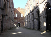
L'Abbazia di San Galgano
|
| Monterotondo Marittimo |
|
|
|
Monterotondo Marittimo
|
| Bolgheri |
|
In Bolgheri, a hamlet belonging to the Municipality of Castagneto Carducci, you can find one of the main natural parks, the WWF fauna oasis. Bolgheri is also famous for hosting some of the most prestigious wineries in the world. Some of best Italian wines come from these hills towards the sea, i.e. Sassicaia, Ornellaia, Grattomacco, Paleo, Masseto, Messorio, Scrio and Guado al Tasso.
Bolgheri’s historical center has maintained much of its original architecture and historical charm. The picturesque village was built around a medieval castle situated on a small slope at the end of the 5-km cypress way.
The latter starts from the via Aurelia, before the XVIIIth-century Oratorio of San Guido. This place has been mentioned and immortalized by the lines of Giosué Carducci in the famous poem “Davanti a San Guido” (1874).
The closest train station is on the outskirts of the town but there are many departures to the nearby town of Cecina.
|
|
|
| Castagneto Carducci |
|
Castagneto Carducci is located in the heart of what is called Costa degli Etruschi, on a graceful hill dominating the sea. Plunged into the green Tuscan countryside, Castagneto Carducci is a charming medieval village, that has been founded around the Castle of the famous Della Gherardesca family, built in the year 1000. The town’s castle is still inhabited by descendants of this dynasty, which remains today one of the oldest families in Italy. The town was awarded its current name in 1907 in honor of the poet Giosuè Carducci. In Via Carducci, in fact, you’ll find the house where the poet lived from 1848 to 1849.
|
|
|
| Sassetta |
|
Not far from Sassetta, a beautiful, unspoilt village in the Val di Cornia, 10 km from the sea, the forested nature park of Poggio Neri offers a variety of itineraries.
The park is located in Bufalaio, about 1.5 km from Sassetta in the province of Sassetta-Suvereto. In the park there are areas for picnics which can be accessed from Casetta Fiorentina, which can be found at the exit of the village of Sassetta, on the way to Prata-Suvereto.
Itineraries in nature at Sassetta | The Poggio Neri Park | www.turismo.intoscana.it
|
|
|
| Suvereto |
|
Suvereto is an evocative medieval village with its circuit of walls still intact, situated but a short distance from the Etruscan city of Populonia. From the village the eye takes in the Tyrrhenian Sea, the Gulf of Follonica and, beyond, the island of Elba.
In 1201 the town received its Charta Libertas and became an independent town state. One of the Maremma area’s most outstanding examples of medieval architecture, Il Palazzo Comunale, dates back to this time. The city walls of Suvereto still encircle the small town.
The name comes from sughero, which in Italian means cork oak.
Enclosed within the old city walls hides a charming town with an imposing fortress, paved streets, historic palazzi, the Church of San Giusto and the Cloister of San Francesco.
Suvereto wines gained recognition in the 1990s and in 2000 a well-respected sub-category of Val di Cornia DOC was named for the town.
The Wild Boar Festival takes place in the historic centre at the beginning of December with exhibits, conferences, food stalls, archery competitions, and processions and recreations in Medieval costume.
Restaurants, many located in former houses built out of stone, offer local specialties like sopressata and sausage made from wild boar, wild boar with olives, pappardelle with wild boar, and game.
|
|
Suvereto, cloistro
|
| Campiglia Marittima |
|
Campiglia Marittima is a renowed and well equipped seaside resort, with wide and beatiful pinewoods, an efficient touristic harbour and an acquatic park. With its narrow streets and the houses ,all gathered around the castle, this typical medieval village, has a very ancient history. An urban settling had been probably existing there since the Etruscan age. In the 8th C., the counts of Gherardesca built there a fortress, on the top of the hill, which became very poweful in the 10th C.
Beside the picturesque historical centre, the surroundings are worth visiting, as the Gothic Pieve di San Giovanni, the Etruscan furnaces, the Rocca di San Silvestro, the spas of Caldana and the ancient calidarium, with its thermal little lake.
The Pieve di San Giovanni is a church in the cemetery of Campiglia Marittima. The Sator, or magic square containing a palindrome was used during Roman times, and surfaced again during the Middle Ages, where it was included in consecrated buildings, often those built by the knights Templar, the warrior monks who defended pilgrims in the Holy Land (San Giovanni in Campiglia Marittima, Abbey of Valvisciolo, Parish Church of Terzagni etc.). It refers to the Mystery of Creation: “The Creator (“sator”) to whom I lean (“arepo”, abbreviated form of “adrepo”) by his actions (opera) upholds (tenet) the celestial beings (rotas)”, constituting a secret instrument used by Medieval Master Builders. The linking of the letters in the square made reference to universal patterns, which protected the relationships between numbers, characteristic of Sacred Geometry. The Master Builder thus reaffirmed that his building was in harmony with the laws of creation, and was stamped with the signature of God. The itinerary will lead you along a fascinating route.
The San Silvestro Archaeo-Mineral Park near Campiglia Marittima retraces for visitors the history of mineral extraction activities in the Campiglia hills.
|
|
Campiglia Marittima, Pieve di S. Giovanni
|
| Piombino |
|
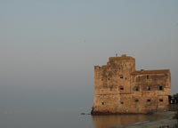
Piombino town (Livorno) is from where set out the ferryboats to the Island of Elba.
Piombino has an ancient historical center, derived from the time in which it was the Etruscans' port, in the surroundings of Populonia. In the Middle Ages, it was instead an important port of the Republic of Pisa.
The hinterland of Piombino hosts a considerable industrial area. Its port is still heavily used, both for industry and for tourism, with ferry-boats to Portoferraio (Elba) and Olbia (Sardinia).
The name Piombino derives almost certainly from Populino, meaning "Small Populonia", which the refugees gave to a small village where they had taken refuge after the city had been attacked by Greek pirates (9th century CE). It is also probable that Piombino had already been founded during the Ostrogoth domination.
The Cassero Pisano(Castle). It is formed by two distinct building, the Fortress, built under Cosimo I de' Medici (1552–53), and the Cassero (late 15th century), the latter used as military jail until 1959.
|
|
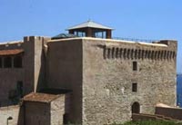
Piombino Castle
|
| Coastal Park of Sterpaia |
|
Coastal Park of Sterpaia
|
|
|
| |
|
The Etruscan Coast territory in Tuscany has much to offer hiking enthusiasts, or those who simply love to walk, with its spectacular fine sand beaches, natural oases, bushland parks and natural uncontaminated environments.
The Coastal Park of Sterpaia extends over 296 hectares, out of which 17 hectares of sandy shores extending over 10 km, 124 hectares of dunal and retrodunal areas, 155 hectares of wood and agricultural glades.
This park is formed by bushland and a coastal area with characteristic fine sand dunes, situated along the stretch of coastline between Piombino and Follonica.
The Park of Sterpaia is ideal for walks or mountain bike rides, combining the pleasure of hiking through bushland with century old oak trees, with the pleasure of swimming in the crystal seas of the Gulf of Follonica, with all the typical natural features of the Maremma Livornese.
The purity of its waters and the numerous services available for swimmers have ensured this area has been awarded the “Bandiera Blu” (Blue Flag) for several years.
Walking in Tuscany | The Coastal Park of Sterpaia
Bosco della Sterpaia Loop trail | 4.91 km
From Torrze Mozza to the Coastal Park of Sterpaia | 2.90 km
Additional walk along Fosso Corniaccia | 2 km
|
|
Fosso Corniaccia |
| |
|
|
| |
|
|
|
|
| |
|
|
|
|
| |
|
|
|
|
| Follonica |
|
Follonica is essentially a very pleasant and popular seaside resort, located at 40 kilometres northwest of Grosseto. Situated on the Gulf of Follonica (Golfo di Follonica), Follonica offers wonderful landscapes from Punta Ala in the south-east to Piombino in the Northwest and towards the sea, until Elba island. |
|
 Torre Mozza |
| |
|
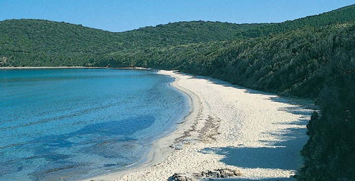
Inside the Follonica Gulf, in the heart of the Natural Reserve of the Bandite of Scarlino, which is divided by a small promontory from Punta Ala, among a multitude of small caves, you will find Cala Violina.
La Riserva Naturale delle Bandite di Scarlino has an adequate and efficient net of signed paths for trekking and mountain bike. The most beautiful path of the area is without a doubt that of the Costiere whose access is possible only on foot, on horse or in bicycle, it pass through beautiful rocky coves of certain beauty, like Cala Francese, Cala Martina, and Cala Violina.
Cala Violina attracts in every period of the year, but in the summer, an exorbitant number of tourists overrun the beach, and you are baffled by the number of boats that are anchored beyond the floaters delimitating the beach. |
|
|
| |
|
|
|
|
| Scarlino |
|
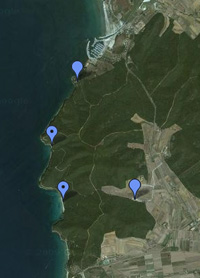
From Scarlino to Portiglione - 10 km
From the castle at Scarlino the trail crosses a chestnut grove, passing on the left the paths toward Poggio Tondo and Tirli, and heads up between Fosso Fedeli and Fosso dell'Uccelliera. From the foot of Monte di Muro it continues along the crest to Poggio Scodella where you can admire a beautiful view of the Tyrrhennian Sea and the Isle of Elba.
From Portiglione to Torre Civette and Punta Ala - 11 km
This itinerary, among the most classic of the Tuscan coast, follows the gravel road which passes the beaches of Cala Francese, Cala Martina, Cala Violina and Cala le Donne. From the camp grounds at the mouth of the Alma River a path runs between the street and the beach to Punta Ala.
From Torre Civete to Portiglione through the Val Martina - 9 km
Together with the previous itinerary, this itinerary creates a beautiful ring-path. It passes many farmhouses and small villages, through the woods of Poggio Moscatello with the Val Martina on the right. After it opens on to the sea, the path turns right at the feet of Poggio la Guardia. A gravel road and the provincial Collacchie road head back towards Portiglione.
From Val Martina to Cala Violina - 3.5 km
The shortest and most popular itinerary in this area can be reached by car from the provincial Collacchie road (follow indications for Cala Violina) and follows a gravel road.[2]
Cala Violina
|
|
|
| |
|
 |
| |
|
|
|
Cala Violina
|
|
|
A walk close to the sea, towards Cala Violina and Cala Martina
|
|
|
| |
|
The beach of Cala Violina is perhaps the most beautiful bay of all of Tuscany. The beach owes its name to the particular nature of the fine white sand it has which tends to produce a "violin-like" sound when you walk bare foot on it. It is enclosed in two different headlands covered with the Mediterranean Vegetation, Cala Violina is also renowned for its transparent waters and fabulous seabed with rows of Posidonia Oceania and masses of sandstone and fish of any dimension.
The beach of Cala violina is in the heart of the Natural Reserve of "Bandite di Scarlino" in the province of Grosseto. The "Bandite" are a forrest complex of great dimensions between Castiglione della Pescaia, Gavorrano, Scarlino and Follonica. If you are in Tuscany and you enjoy trekking and mountain biking as well as resting on the beach, you can also reach Cala Violina by following the path called "il sentiero delle Costiere" (the most beautiful of the entire area), which you can reach only on foot, with a bike or by horse.
The path reaches spectacular cliffs that develop along the coast (it extends from Cala Violina to Cala Martina and Cala Francese) and it develops all along the coast. It is level and easy to walk through so you can relax as you enjoy the scenery on the bay of Follonica, the sunset on Piombino, Isola d'Elba, Isola di Cerboli, Montecristo, the peninsula of Punta Ala and (if it's your lucky day) the mountains of Corsica.
|
|
A walk close to the sea, towards
Cala Violina and Cala Martina
|
| Gavorrano |
|
Gavorrano is located on the northern slope of Poggio Ballone, east of Scarlino, in an area extremely rich in terms of mining, especially for large deposits of pyrite which were intensively exploited until the early 1980s.
The town is famous because of Pia dei Tolomei ("Siena mi fé, disfecemi Maremma" whose fate is related in the Divina Commedia, Purgatory, Dante).A chapter in the history of the village of Gavorrano concerns the life of Pia de 'Tolomei, a lady from Siena who met her death in Castel di Pietra, located in the east of the town. She was married to Nello Pannocchieschi, who is known to have been lord of that castle, mayor of Volterra and Lucca, captain of the Guelph cuts in 1284 and lived until at least 1322. He shut up his wife in his castle, and had her murdered in 1297 by having her thrown out of a window, after having locked her up for a while in his castle, perhaps because of her supposed infidelity, perhaps because he desired to get rid of her to marry someone else. The story was made famous by Dante in the fifth canto of his Purgatorio. The story is commemorated on the feast of Salto della Contessa ("The jump of the Countess") which is held in Gavorrano every second Sunday of the month of August.
|
|
Gavorrano |
| Caldana |
|
The Church of San Biagio, a rare example of sacred Renaissance architecture in southern Maremma, was recently recognised as national monument.
The church was commissioned in the 16th century by the Agustini family from Siena, whose coat-of-arms can still be seen at the centre of the pediment.
Its similarities with some parts of the church of the same name in Montepulciano, especially as regards the façade, would seem to attribute it to the school of Antonio da Sangallo the Elder, even if recent studies, which are still in progress, would appear to attribute it to Michelangelo.
Inside the church is the high altar fresco by Giuseppe Nicola Nasini, which depicts Saint Biagio and Saint Guglielmo adoring the Crucifix, while two canvases portraying Saint Luca with the Madonna with Child and the Assumption of the Virgin can be attributed to Sienese artists of the first half of the 17th century. The 17th century stoup is in local marble known as “Portasanta”.
The thermal waters of the Valle del Sole Spa come from the hot springs of Caldana. Both the Etruscans and the Romans knew of the therapeutical effect of this springs. The Spa water has a natural temperature of 45? and comes from a crater in Caldana while the swimming pool water comes from the springs of Canneto.
|
|
Caldana |
| Vetulonia |
|
Vetulonia, formerly called Vetulonium (Etruscan Vatluna), was an ancient town of Etruria, Italy, the site of which is probably occupied by the modern village of Vetulonia, which up to 1887 bore the name of Colonnata and Colonna di Buriano: the site is currently a frazione of the comune of Castiglione della Pescaia
The wide necropolis of Vetulonia features incineration and inhumation tombs, grouped by “continuous circles”, each consisting of a tumulus of beaten earth with a diameter of 20-30m, bordered by flags of stones vertically arranged. A wide range of funeral offerings were also found. The necropolis includes large monumental burials with dromos and covered chambers with fake tholos domes and central pillars. One of the most representative examples of these tombs can be seen along Via dei Sepolcri: it’s the Tomb of Pietrera (7th century B.C.). Here archaeologists found some of the most ancient examples of in-the-round Etruscan statues made of stone.
Museo Civico Archeologico di Vetulonia "Isidoro Falchi"
Isidoro Falchi, the Archaeological Museum of Vetulonia, just a few minutes’ drive from Punta Ala, describes the area's history through the archaeological finds uncovered in Vetulonia and the surrounding areas.
|
|
|
| |
|
|
|
|
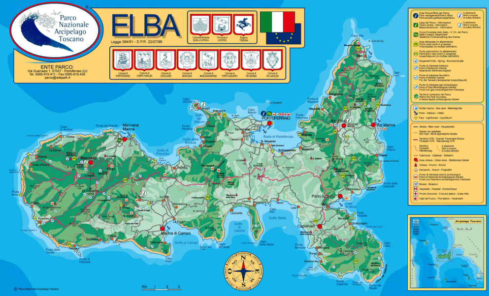
| Elba |
|
The Island of Elba is the third largest Italian island after Sicily and Sardinia and is the largest in the Tuscan Archipelago. It has recently become part of the Tuscan Archipelago's National Park together with the islands of Pianosa, Capraia, Montecristo, Giglio and Giannutri.
Elba has a coastline of 147 km: its main mountain (Monte Capanne) is 1019 metres high, accessed via pathways or by a panoramic cable car.
Already in acient times Elba's destiny was always deternined by two factors: its strategic position and the richness of its mineral resources. Due to these characteristics, it was often the object of conquest for the various powers along the Mediterranean. For the Etruscans and the Romans Elba represented an inexhaustible source of riches and the iron from Elba contributed to the prospering of their civilazation. |
|
 |
| |
|
|
|
|
| Tuscan archipelago |
|
The Tuscan archipelago is a chain of islands between the Ligurian Sea and Tyrrhenian Sea, west of Tuscany. The archipelago contains the islands of Elba (the largest island of the group), Pianosa, Capraia, Montecristo, Giglio, Gorgona and Giannutri, all of which are protected as part of the Tuscan Archipelago National Park.
According to legend, the Tuscan Archipelago originated from a jewel that slipped off Venus’s neck, the goddess of beauty and love, and fell into the Tyrrhenian Sea.
|
|
|
| |
|
|
|
|
| |
|
Enlarge map Massa Marittima and the Colline Metallifere |
|
|
|
|
|

The Colline Metallifere Cooperative | www.coopcollinemetallifere.it
The Colline Metallifere Cooperative has planned and made up several tours, both in the historical centre of Massa Marittima and in the neighborhood of the town; according to your own interests, it’s possible to choose among the different routes we suggest you.
Giovanna Bianchi, The Silver Rush in Tuscany’s Wild West | Medieval Archaeology in the Metal Hills | www. penn.museum (pdf)
Walking in Tuscany| Massa Marittima and the Metalliferous Hills, the Colline Metallifere
|
|
|
| |
|
|
|
|

|
|
|
|
 |
|
|
|
 |
|
|
|
 |
|
|
|
 |
|
|

|
| |
|
|
| |
|
 |
| |
|
Isola d'Elba
|
|
|

[0] Photo by Markus Bernet, icensed under the Creative Commons Attribution-Share Alike 2.5 Generic license.
[1] Giovanna Bianchi, The Silver Rush in Tuscany’s Wild West | Medieval Archaeology in the Metal Hills, University of Pennsylvania Museum of Archaeology and Anthropology
[2] Parco Archeologico del Lago dell'Accesa ["Lago dell'Accesa" Archaeological Park] | www.brunelleschi.imss.fi.it


|
|
|
This article incorporates material from the Wikipedia articles Gavorrano and Piombino, published under the GNU Free Documentation License.
Wikimedia Commons has media related to
|
| |
|
|
|