Abbadia San Salvatore

Abbey of Sant'Antimo

Albarese

Acquapendente


anghiari

Archipelago Toscano


Arcidosso


Arezzo


Asciano


Badia di Coltibuono


Bagni San Filippo

Bagno Vignoni

Barberino Val d'Elsa

Beaches

Bolsena Lake


Bomarzo

Brunello di Montalcino

Buonconvento

Campagnatico


Capalbio


Castel del Piano


Castelfiorentino

Castell'Azzara

Castellina in Chianti


Castelmuzio


Castelnuovo Bererdenga


Castiglioncello Bandini


Castiglione della Pescaia


Castiglione d'Orcia


Castiglion Fiorentino


Celleno


Certaldo


Chinaciano Terme


Chianti


Chiusi


Cinigiano


Città di Castello

CivitÀ di Bagnoregio


Colle Val d'Elsa


Cortona


Crete Senesi


Diaccia Botrona

Isola d'Elba

Firenze


Follonica


Gaiole in Chianti


Gavorrano

Gerfalco


Greve in Chianti


Grosseto


Lago Trasimeno


La Foce


Manciano


Maremma


Massa Marittima


Montagnola Senese


Montalcino


Monte Amiata


Monte Argentario

montecalvello

Montefalco


Montemassi


Montemerano


Monte Oliveto Maggiore


Montepulciano


Monteriggioni


Monticchiello


Monticiano


Orbetello


Orvieto


Paganico


Parco Naturale della Maremma


Perugia


Piancastagnaio


Pienza


Pisa


Pitigliano

Prato

Radda in Chianti


Roccalbegna


Roccastrada


San Bruzio


San Casciano dei Bagni


San Galgano


San Gimignano


San Giovanni d'Asso


San Quirico d'Orcia


Sansepolcro


Santa Fiora


Sant'Antimo


Sarteano


Saturnia


Scansano


Scarlino


Seggiano


Siena


Sinalunga


Sorano


Sovana


Sovicille

Talamone

Tarquinia


Tavernelle Val di Pesa


Torrita di Siena


Trequanda


Tuscania


Umbria


Val d'Elsa


Val di Merse


Val d'Orcia


Valle d'Ombrone


Vetulonia


Viterbo

Volterra


Walking in Tuscany
             
 
I T      N L
Castell’Azzara

album Surroundings


Castell’Azzara


“Like an eagle’s nest, Castell’Azzara hung on the precipices of Monte Civitella”,
so the 19th century traveler Edward Hutton described the view of this land situated on a spur of rock.


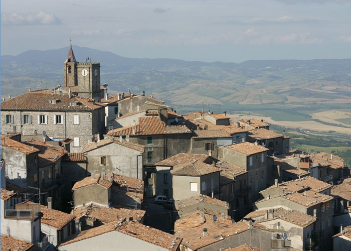
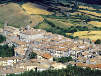
Placed at the foot of Monte Civitella (which can be easily climbed starting from the Cave and by following the Anello paths) Castell’Azzara dominates the Paglia valley (in the distance the Apennines can be seen) and is the highest (about 800 m altitude) of the entire Amiata district. The ancient village is situated in the northern part of the Area dell’Tufo (Tuff Area) and is one of the most fascinating and interesting locations the Maremma.
The ancient Castellum Lazzeri, according to the testament deeds of the Aldobrandeschi in 1216, derives its name from the "zara" game, meaning a game of dice which the three Aldobrandeschi descendents used to decide over their property.[1]

The stone boundary wall can still be singled out, even though by now it has been incorporated by homes: there is still a stone arch gate south-east, followed by a vault passage which is bored by a well in the center and to the west, a rectangular tower with crenellation (the coat of arms shows three towers). The church of San Nicola holds a seventeenth century painting of the Sienese school, depicting the Virgin, Mary with saints Martino and Nicolò, while the small church of the oratory holds a canvas depicting the Madonna del Rosario and saints Domenico and Caterina da Siena, also of the seventeenth century Sienese school. The Chiesa della Madonna del Rosario is decorated with splendid frescoes.

  Klik voor het volgende hoofdstuk
Castle Rocca Silvana near Selvena, Castell’Azzara, Monte Amiata Area,

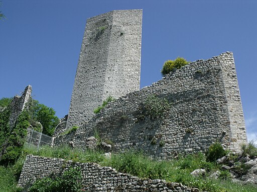
Castle Rocca Silvana near Selvena, Castell’Azzara, Monte Amiata Area [3]


Main sights are the Rocca aldobrandesca, the Chiesa di San Nicola, the Chiesa della Madonna del Rosario, the Villa Sforzesca, the Chiesa di San Gregorio Magno.

The Chiesa della Santissima Trinitá (Church of the Sacred Trinity)was built for the Aldobrandeschi family, it houses wonderful works of art and very old paintings.

The Chiesa di San Nicola (the church of San Nicola ) dates from 1841-1850 and was built over the foundations of a late XIII century structure. The façade is typically divided into three sections by pilaster strips, with a raised central portion that includes the tympanum. The interior is divided into three naves. In the left nave there is a XVII century painting of the Assumption of the Virgin with Saints Martin and Nicholas. Outside there is a stunning bell tower.

The construction of the Chiesa della Madonna del Rosario (Church of the Madonna del Rosario) dates back to the 16th century and has a plain façade, a rectangular interior and trussed roof. Inside we can see fragments of frescoes dating from the latter half of the XVI century and a XVII century painting of Our Lady of the Rosary between Saints Dominic and Catherine of Siena.


Chiesa di San Gregorio Magno alla Villa Sforzesca (GR)

La Chiesa di San Gregorio Magno alla Villa Sforzesca [1]


The Chiesa di San Gregorio Magno (Church of St. Gregorio Magno) is a beautiful religious structure which rises just outside the town. Originally its function was as a place of prayer and the residence of the Sforza Counts. The church of San Gregorio Magno presumably dates from the same period as the villa, that is the second half of the XVI century. It has a plain façade with an architraved portal. The interior is a rectangle and houses a painting of Cardinal Sforza Kneeling Before the Virgin and Child and a fresco portraying Saint Augustine Abbot.

Rocca Aldobrandesca (Aldobrandesca Fortress) is a stunning building of Medieval origin, right next to a very impressive clock tower. Of the original complex the palace and the watchtower remain. The Villa Sforzesca was built at the end of the 16th century for the Sforzesca family.

Selvena is renown for the imposing ruins of the Rocca Silvana which dominate the Morone mine area. The ancient castle (the most ancient account dates back to 1081) rose in a strategic position over a hill with a sheer drop to the Valle del Fiora, and bordered with the estates of the Sovana and Santa Fiora counts, in an area which already in 1216 was important for its silver mining resources, according to the testament deeds of the Aldobrandeschi family. Its strategic importance is confirmed by the choice made by the imperial troops of Frederick II, commanded by Pandolfo da Fasanella, who chose it as their operative base against Sovana (1241).

The area of the Pigelleto Nature Riserve is dominated by Poggio Pampagliano (969m), which with Poggio La Roccaccia and Poggio Roccone, a little lower, forms a curved ridge towards the north-east, working as a watershed between the basins of the river Paglia and the river Fiora. The Reserve protects a heterogeneous woodland rich in vegetal species, where the spontaneous presence of the Silver Fir is particularly significant. Pigelleto wood is mainly a high-trunk tree wood, deriving from the kind of cutting it was practiced during the mining activity period, which has probably contributed to maintain the spontaneous renewing of the Silver Fir.

Mount Penna Nature Reserve spreads over 1,050 m circa and is located between Selvena and Castell’Azzara. It features a group of rises on the South-Western side of Mount Amiata, with the highest peaks of Poggio della Vecchia (reaching an altitude of 1,086 m) and Civitella (1,107 m).

The flora mainly consists of woods: turkey oaks and field maples prevail at higher altitudes together with major and flowering ashes; in lower areas beech trees are the main feature together with chestnuts sometimes reaching exceptional sizing.

The reserve fauna includes mammals such as foxes, porcupines, roe-deers, wild boars, beech martens, weasels and fallow deers; predatory birds include buzzards, European sparrowhawks, short-toed eagles and tawny owls. The reserve also hosts an interesting population of bats which find shelter in the calcareous grottoes in the area.[2]


La Rocca Silvana, Selvana

Castle Rocca Silvana near Selvena, Castell’Azzara, Monte Amiata Area   RoccaSilvanaCastellAzzara4   RoccaSilvanaCastellAzzara5
Viuw of the Castle Rocca Silvana [3]   Castle Rocca Silvana near Selvena [3]   Castle Rocca Silvana near Selvena [3]


www.abiesalba.com


The Pigelleto Nature Riserve


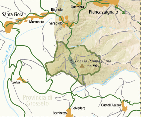
Map Miniera del Siele - Castell'Azzara


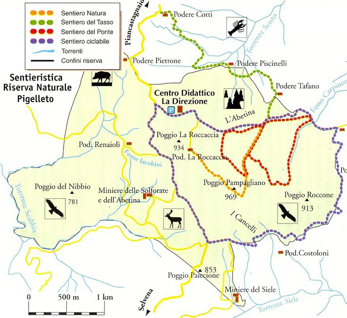
Pigelleto Reserve, situated in the south of Piancastagnaio, protects an heterogeneous woodland area rich in vegetal species, among which the presence of the Silver Fir as spontaneous species is particularly important. The history of Pigellato wood, like that of the surrounding territory, has been deeply marked, at least in the last two centuries, by the presence of cinnabar layers.

The Pigelleto Nature Reserve extends over a territory of 862 hectars between Siena and Grosseto. It is located in Piancastagnaio, a small town South-East from Monte Amiata in Tuscany. The Pigelleto Natural Reserve has been incorporated by the Regional Administration of Tuscany (Regione Toscana) in 1996. It used to host one of the most important quicksilver mines of Monte Amiata, today completely abandoned. The Environmental Education Centre La Direzione is inside the Reserve itself and includes the Visitors Centre, the Environmental Education Labs and facilities for visitors who wish to spend some time in peace and tranquillity.

The Siele mine is inside the Pigelleto natural reserve (“pigello” is the name the people of Amiata give to the white fir, a majestic tree that can reach heights of 50 m).
Mining on Monte Amiata dates back to ancient times: the Etruscans used cinnabar (the mineral that mercury is extracted from) to paint earthenware and frescoes in tombs, digging up to 40 m into the earth to extract it. The largest deposits are located in Santa Fiora, Castell’Azzara, Abbadia San Salvatore and Piancastagnaio.
In modern times, the Siele mine started to be used for industrial ends towards the middle of the 1800s. Siele was a complex site comprising both mines (galleries and shafts) and plants for working the mineral. In the early 1900s, a village grew up around the site, with houses, schools and a church.
After a period of great expansion, also due to orders from the war industry, mining activity ceased in 1973: it was the third largest mine in the world after Almadén (in Spain) and Abbadia San Salvatore.


Walking in the Riserva Naturale del Pigoletto | Between Saragiolo, Miniera del Siele, Castell'Azzara, Podere La Roccaccia and Castell'Azzara

Seragiolo-Miniera del Siele-Castell'Azzara (n° 16 )

Continuing along the pathway n. 15, the road climbs a little till the crossroads to the Podere Praticce, and then it descends towards the Senna Torrnt and climbs again, around the Poggio La Roccaccia, till the homonymous farm house (not far from the farm house the pathway reaches the crossroads with the pathway number 17, known as â??Roccacciaâ??). Once got the Poggio Pamalliano over the pathway reaches the Cancelli crossroads and then the old mine.

The whole pathway, till the Siele mine, about 8 km long and of average difficulty, at an altitude of about 1000mt, can be covered in little more than 2 hours.

Pod. La Roccaccia - Castell'Azzara (n° 17)

From Castell'Azzara with this pathway the valley of the Siele torrent till the Podere La Pinza can be crossed, and then the pathway continues towards the Podere San Filippo, the Fosso Carpineto and the Podere La Roccaccia, where it joins pathway n. 16.
As far as the final stretch of the pathway 17 is concerned, it coincides, in the area La Roccaccia, with the pathway 16.

The whole pathway, of about 8 km, is very demanding and difficult and can be covered only on foot and by fit excursionists in about 3 hours.

From Selvena to Castell'Azzara 7 km

La traversata del massiccio del Monte Penna e del Monte Civitella inizia con una ripida salita e prosegue toccando il Poggio della Vecchia e la sorgente delle Fossatelle. Segnavia n. 19.

     
From Castell'Azzara to Montebuono and to Sovana 17 km

Un lungo percorso su strade sterrate conduce dal Monte Civitella, propaggine sud-orientale dell'Amiata, alle valli del Fologna e del Fiora. Dopo aver costeggiato la rupe di Monte Vitozzo si traversa la provinciale Selvena-Sorano e si raggiunge Montebuono. Alla fine, prima di salire a Sovana, si scende al Fosso Picciolana e si toccano le tombe Ildebranda e Pola. Segnavia n. 3.


Cycling in Tuscany
Cycling in Southern Tuscany | 35 Cycleways and cycle routes | 35 Percorsi ciclistici

24. La riserva del Pigelleto e il Monte Penna

Riserva Natura le del Pigelleto - Castell’Azzara - Selvena - Riserva Natura le del Pigelleto

26. La valle del Fiora e le città del Tufo

SANTA FIORA - SELVA - SELVENA - ELMO - SORANO - PITIGLIANO - SOVANA - SAN MARTINO SUL FIORA - BIVIO CATABBIO - SEMPRONIANO - PETRICCI - TRIANA - LOCALITA' AIOLE - SANTA FIORA


I T

The Pigelleto Sanctuary and Monte Penna - 22 km


[1] The legend of Castell’Azzara | Castell’Azzara is one the castles built in Maremma by the Aldobrandeschi family. Its origins and name are linked to an old legend narrating that three young brothers belonging to the Aldobrandeschi aristocratic family from Santa Fiora used to go hunting for game in the nearby woods. One day, after a long day of hunting, they found themselves very far from the village and decided to build there a castle to rest during their days out. According to tradition, the Aldobrandeschi owned a castle for each day of the year, so building another one was not a big deal! Once the new castle was completed, the three brothers started arguing, since each of them wanted to become its absolute owner. But in the end they realised their brotherhood could have been spoilt by such a foolish wish, so they decided to gamble on the castle playing “zara”, the dice game also mentioned by Dante. In memory of that episode, they first called it “Castello giocato a zara”, which in the long run became Castell’Azzara. In the following years, the castle was also provided by three towers topped with three large stone dices, and a village developed in the surrounding area. Both towers and dices are still shown in the village coat of arms.[From: Parco degli Etruschi | www.parcodeglietruschi.it]

[2] Source: Parco degli Etruschi | Mount Penna Nature Reserve (Castell'Azzara)

[3] Photo byLigaDue, licenziato in base ai termini della licenza Creative Commons Attribuzione 3.0 Unported

Address Mount Penna Nature Reserve: Castell’Azzara (GR)

How to get there:
From Grosseto take the SS "Due Mari" to Paganico, then continue towards Arcidosso, Santa Fiora and finally Castell’Azzara. Drive past the town and, after about 2 km, turn right

Contact: The Reserve is open for guided tours through the speleological group "L’Orso". For more information call +39 0564 951032


Castell'Azzara borders Piancastagnaio (SI), Proceno (VT), Santa Fiora, Semproniano and Sorano.


Enlarge map