24. The Pigelleto Sanctuary and Monte Penna - 22 km
Riserva Naturale del Pigelleto - km 0 - Castell’Azzara - km 10 - Selvena - km 15.5 - Riserva Naturale del Pigelleto - km 22
Starting point and arrival: Riserva Naturale del Pigelleto (about 7 km from Piancastagnaio)
Distance in kilometres: 22 km
Difference in altitude: 450 m
Type of road: 17 km tarred road + 5 km dirt track
Bicycle: all-terrain and roadster
Difficulty: average
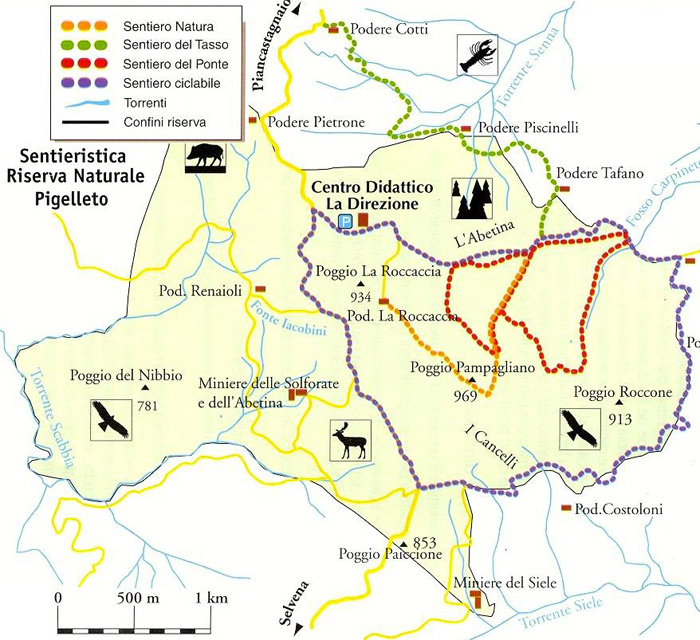
NOTES: The itinerary is virtually a tour around Mount Penna and the most demanding stretch is the climb on a concrete surface from Castell’Azzara to the source of the Ficoncelle (about 1 kilometre). A tour of the Pigelleto Sanctuary on its cycling lane of about 8 kilometres, 5.5
of which on a dirt track, is recommended (it follows the recommended routes Nos. 16 and 17) starting from the Environmental Didactic Centre “La Direzione” for a round tour of the Roccone hillock :
Enquiries by La Direzione - tel. 0577.788004 - 347.1210927 - e-mail: pigelleto@imeservizi.it
From the the Pigelleto Sanctuary one can cycle directly downhill on a tarred road to Castell’Azzara or continue on a dirt track (about 3 kilometres more) crossing the Sanctuary to emerge on the tarred road downhill to Mount Penna. At a crossing one continues on the left on the S.P. 4 in the direction of Castell’Azzara (10) to be reached after 6 kilometres on a panoramic road easy to cycle on.
Shortly before entering the centre of the town one turns right where a small path slopes decidedly up the sides of Mount Penna. The climb is steep but short and soon the tarred road gives way to the dirt track. Cleared on the right the source of the Ficoncelle (11) the road continues mainly downhill to reach the small Selvena hamlet (15.5).
Here one takes the S.P. 34 on the right which climbs nonstop uphill (follow the road signs to Piancastagnaio and Abbadia San Salvatore) as far as a crossing where one cycles on mainly uphill as far as the Pigelleto Sanctuary (22).
