Abbadia San Salvatore

Abbey of Sant'Antimo

Albarese

Acquapendente


anghiari

Archipelago Toscano


Arcidosso


Arezzo


Asciano


Badia di Coltibuono


Bagno Vignoni

Barberino Val d'Elsa

Beaches

Bolsena Lake


Bomarzo

Brunello di Montalcino

BuOnconvento

Campagnatico


Capalbio


Castel del Piano


Castelfiorentino

Castell'Azzara

Castellina in Chianti


Castelmuzio


Castelnuovo Bererdenga


Castiglioncello Bandini


Castiglione della Pescaia


Castiglione d'Orcia


Castiglion Fiorentino


Celleno


Certaldo


Chinaciano Terme


Chianti


Chiusi


Cinigiano


Città di Castello

CivitÀ di Bagnoregio


Colle Val d'Elsa


Cortona


Crete Senesi


Diaccia Botrona

Isola d'Elba

Firenze


Follonica


Gaiole in Chianti


Gavorrano

Gerfalco


Greve in Chianti


Grosseto


Lago Trasimeno


La Foce


Manciano


Maremma


Massa Marittima


Montagnola Senese


Montalcino


Monte Amiata


Monte Argentario

montecalvello

Montefalco


Montemassi


Montemerano


Monte Oliveto Maggiore


Montepulciano


Monteriggioni


Monticchiello


Monticiano


Orbetello


Orvieto


Paganico


Parco Naturale della Maremma


Perugia


Piancastagnaio


Pienza


Pisa


Pitigliano

Prato

Radda in Chianti


Roccalbegna


Roccastrada


San Bruzio


San Casciano dei Bagni


San Galgano


San Gimignano


San Giovanni d'Asso


San Quirico d'Orcia


Sansepolcro


Santa Fiora


Sant'Antimo


Sarteano


Saturnia


Scansano


Scarlino


Seggiano


Siena


Sinalunga


Sorano


Sovana


Sovicille

Talamone

Tarquinia


Tavernelle Val di Pesa


Torrita di Siena


Trequanda


Tuscania


Umbria


Val d'Elsa


Val di Merse


Val d'Orcia


Valle d'Ombrone


Vetulonia


Viterbo

Volterra


Walking in Tuscany


Kaart Miniera del Siele - Castell'Azzara

Walking trails in Tuscany Surroundings


Wandelen in La Riserva Naturale del Pigelleto | Saragiolo - Miniera del Siele - Castell'Azzara | Podere La Roccaccia - Castell'Azzara


Piancastagnaio | The Pigelleto Natuurreservaat

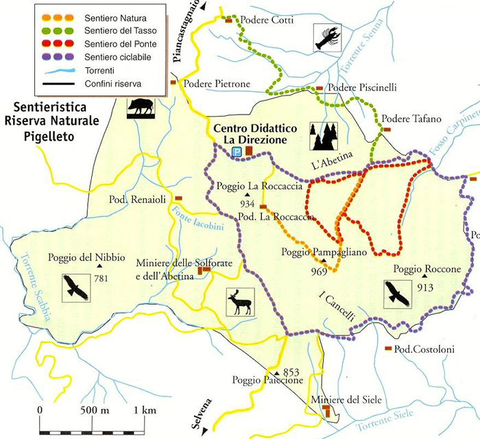
Aan de zuidkant van de Monte Amiata, in de gemeente Piancastagnaio, bevindt zich het prachtige Pigelleto reservaat. Het is een ongerept natuurgebied van 862 hectaren, met hoogtes die schommelen tussen de 600 en 969 meter boven zeeniveau. Het grootste deel van het reservaat is bebost. Door het gebied lopen talloze wandelpaden en mountainbikeroutes.

Het gebied van 862 ha wordt gedomineerd door de Poggio Pampagliano (969 m), de Poggio La Roccacciaen de iets lager gelegen Poggio Roccone.
Pigello
is de naam die de bewonders van de Monte Amiata gaven aan de witte den, een majestueuze boom die tot 50 m hoog kan worden.
Het natuurreservaat beschikt over een milieu-educatiecentrum. Dit bevindt zich in de voormalige kantoren van de nabijgelegen Siele mijn. De mijn zelf is overigens ook een interessante bezienswaardigheid, in industrieel én archeologisch opzicht. Het was ooit de belangrijkste kwikmijn in het Amiatagebied, en is nu volledig verlaten.

De paden 16 en 17 maken deel uit van de paden die uitgetekend werden door Il Parco Museo Museo delle Miniere dell'Amiata.


Mappa Pigelleto Natural Reserve

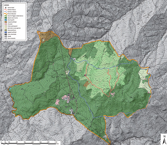
Carta escursionistica della Riserva Naturale Pigelleto[1]


Het Pigelleto Natuurreservaat heeft zelf vier wandelingen gemarkeerd.

The Sentiero Natura | The Nature Trial | Het natuurvoetpad

De wandeling begint aan Podere La Roccaccia en eindigt in het Environmental Education Centre La Direzione. Get is een prachtige wandelroute met een lengte van ongeveer 2,5 km. Onderweg tref je informatie aan over de flora en fauna in het gebied en er zijn twee rustplaatsen waar je kan pauzeren. Je hebt op dit pad een grote kans om reeën en wilde zwijnen tegen te komen. Of zelfs een stekelvarken, een das of roofvogels als de havik, de wespendief of de zeldzame slangearend.
Het pad valt soms samen met wandeling 16 die Saragolo verbindt met de Siele Mijn.

Il Sentiero del Tasso | The Yew Trial | Het dassenvoetpad

Dit pad dat een deel is van wandeling 16 heeft een lengte van ongeveer 2 km en voert langs de belangrijkste stukken natuur van het gebied. Deze route kan alleen onder begeleiding van een officiële gids worden gelopen. Reeën en wilde zwijnen zal je zeker op uw pad treffen.

Il sentiero del Ponte | The Bridge Trial | Het brugvoetpad

Dit pad slingert door het reservaat en overlapt gedeeltelijk het natuurvoetpad. Het heeft een lengte van ongeveer 4 km. Bij de vervallen Podere S.Ignazio bevindt zich een rustplaats.
Il sentiero del Ponte è lungo nel complesso circa 4 km ed è stato tracciato dalla Comunità Montana. Si articola del tutto all'interno della riserva con un circuito ad otto sovrapposto per un piccolo tratto al Sentiero Natura. Sul suo tratto è disponibile un'area di sosta in corrispondenza di un vecchio rudere (Podere S.Ignazio) immersa nel bosco di faggi.

Il Sentiero Ciclabile | Cycling Trail | Het fietspad

Deze route heeft een lengte van ongeveer 6 km. De asfaltwegen zijn voorbehouden an mountainbikes. De route doorkruist de bossen en velden van het reservaat, gaat de Poggio Roccone over en eindigt bij de Siele mijn.

n° 16 Seragiolo-Miniera del Siele-Castell'Azzara

Continuing along the pathway n. 15, the road climbs a little till the crossroads to the Podere Praticce, and then it descends towards the Senna Torrnt and climbs again, around the Poggio La Roccaccia, till the homonymous farm house (not far from the farm house the pathway reaches the crossroads with the pathway number 17, known as â??Roccacciaâ??). Once got the Poggio Pamalliano over the pathway reaches the Cancelli crossroads and then the old mine.

The whole pathway, till the Siele mine, about 8 km long and of average difficulty, at an altitude of about 1000mt, can be covered in little more than 2 hours.

Going on once passed the mine, the pathway climbs up till the Ripa di Selvena, and then to the Poggio della Vecchia, the Spring Fossatelle, the Poggio Ciabattino, and then climbs down towards Castellâ??Azzara.
This last stretch, which can be covered only on foot or mountain bike, is quite demanding because of the uneven soil and for the difference of altitude of about 400 m (till 1200 m altitude) to be faced. On foot it can be covered in about 2 hours (6 km).
The pathway can be entirely covered by mountain bike but it is not unsuitable for the horses in the stretch from the Siele mine to Castellâ??Azzara.

It is possible, from the Ripa di Selvena, to climb down through a well-kept pathway of the Comunità Montana, till the village of Selvena, starting again then from Belvedere to return, through the, pathway n.19 to S. Fiora.


n° 17 Pod. La Roccaccia - Castell'Azzara

From Castell'Azzara with this pathway the valley of the Siele torrent till the Podere La Pinza can be crossed, and then the pathway continues towards the Podere San Filippo, the Fosso Carpineto and the Podere La Roccaccia, where it joins pathway n. 16.
As far as the final stretch of the pathway 17 is concerned, it coincides, in the area La Roccaccia, with the pathway 16.

The whole pathway, of about 8 km, is very demanding and difficult and can be covered only on foot and by fit excursionists in about 3 hours.
The altitude varies from the 800 m of Castellâ??Azzara, to 864 m, and then it climbs down to the 500 m of the Siele and climbs up again to about 1000 m.

An alternative is represented by a pathway of the Comunità Montana which, starting at about 1 km distance from the farm house La Pinza, goes towards the Podere San Francesco, and from here, passing southern from Poggio Roccone, it leads to the Podere Costoloni and then to the Siele mine, on the pathway 16, creating with stretches of the pathways 16 and 17 a small ring of the upper basin of the Siele river.
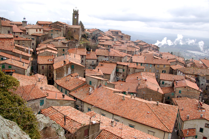


Klik voor het volgende hoofdstuk

Piancastagnaio


Piancastagnaio grenst aan Abbadia San Salvatore, Castell'Azzara, Proceno, San Casciano dei Bagni en Santa Fiora.

Comune

De brochures Amiata without haste... By foot (Itineraries) en Amiata by bike (Itineraries) van dezelfde vereniging geven overzichtelijke informatie. Er is ook een uitgave in boekvorm (it), Amiata senza fretta... a piedi waarin twee wandelingen uitvoerig beschreven worden (Il Sentiero Natura en Il grande anello del Pigelleto).

Kaarten
Kompass kaart 653 Pienza - Montalcino - Monte Amiata (1:50.000) is de aangewezen kaart om dit gebied te voet of met de fiets te verkennen. De kaart is gedetailleerd, met ingetekende wandelroutes maar ook met (niet bewegwijzerde) wandel- en fietsroutes en MTB routes.

Een mooie selectie wadelingen p Monte Amiata vind je hier:

Trekking Monte Amiata | Percorsi per scoprire le meraviglie del Monte Amiata


Grotere kaart weergeven


[1] Monte Amiata | Carta escursionistica della Riserva Naturale Pigelleto