| |
|
The Metalliferous Hills
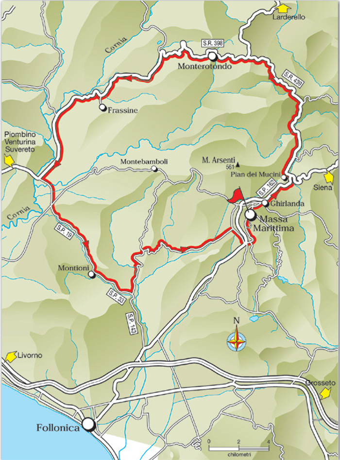
Massa Marittima - Monterotondo - Montioni - Fattoria Marsiliana - Massa Marittima
2. The Metalliferous Hills
Massa Marittima Km 0 - Monterotondo Km 20 - Montioni Km 54 - Fattoria Marsiliana Km 58 - Massa Marittima Km 73.3
Starting point and arrival: Massa Marittima
Distance in kilometres: 73.7 km
Difference in altitude: 720 m
Type of road: tarred
Bicycle: roadster and all-terrain
Difficulty: average - demanding
NOTES: This itinerary loses itself in the Metalliferous Hills passing by the Monterotondo area where geothermal energy is produced. It slopes down the Val di Cecina and encroaches for a short stretch in the Livorno Province. The most demanding stretches are the climb from Pian dei Mucini to Monterotondo and the ups and downs of the Marsiliana road. Massa Marittima is a place of great touristic attractions and it undoubtedly deserves a lengthy visit.
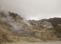
A poca distanza dal centro storico del paese Monterotondo Marittima, è situato l’ingresso del Parco delle Biancane.
Il Parco naturalistico Parco delle Biancane con le sue manifestazioni geotermiche caratterizza in modo suggestivo tutto il paesaggio facendolo apparire quasi irreale.
Il Parco fa parte del Parco tecnologico e archeologico delle Colline Metallifere grossetane divenuto nel 2010 Geoparco UNESCO e quindi di grande rilevanza a livello mondiale.
Montioni Natural Reserve
At the center of a vast area covered by Mediterranean scrub and forests of holm oaks, nature park Montioni looks like an island of green hills that extends over 5000 hectares, where there are also important archaeological and historical discovery.
The park, which is part of the famous park system of the Val di Cornia, contains a fascinating natural heritage, populated by numerous species of birds and a rich fauna consists of wild boar, roe deer, deer and porcupines.
Leaving Massa Marittima one takes the provincial road S.P. 162 to Siena. Having crossed the Ghirlanda hamlet one cycles on the deep valley road, mainly uphill as far as Pian dei Mucini (4). After 700 metres in front of a tavern one turns to the left and follows the road signs to Monterotondo and Larderello. One then takes the regional road S.R. 439 which after having crossed Pian dei Mucini (3 kilometres of even road) starts decidedly uphill following the indication to Larderello.
After about 4.5 kilometres one clears the hill and cycles downhill for 1.5 kilometres and then uphill for further 3 kilometres as far as a crossroads (16.7), where one turns to the left to Monterotondo on the regional road S.R. 398 “Val di Cornia”. Here the ascent comes to an end and the descent to the urban area of Monterotondo (20) starts.
At the crossing in the centre of the town one cycles downhill on the right in the direction of Piombino and Venturina. With wide bends the road “plunges” rapidly to the bottom of the Val di Cornia. One rides through the plain by the locality Frassine (37.5) to continue on a predominantly slight descent for about 9 kilometres as far as a bend to the right (46.7) not to be missed. Here one leaves the regional road S.R. 398, that continues in the direction of Suvereto, to turn left in the direction of Follonica and Massa Marittima on the provincial road S.P. 19 reaching Montioni after 8 kilometres (54.7) where a refreshment stand is to be found. Moving on the provincial road S.P. 19 and through the province boundary Livorno-Grosseto the provincial road S.P. 19 becomes the S.P. 33. After 3.2 kilometres one turns left taking the provincial road S.P. 143 “Marsiliana” (57.9). It is one of the most enjoyable roads to cycle on: it winds through hills in a very appreciated landscape.
Along a stretch of 8 kilometres the road varies quite a lot in continuous ups and downs, then it remains level for 4 kilometres arriving within sight of Massa Marittima. When reaching a T-crossing (70.1) one turns right cycling for 1.1 kilometres on a lovely cypresses fringed avenue as far as a further crossing, continuing then across the regional road S.R. 439 to take the provincial road S.P. 151 leading uphill to the old town of Massa Marittima (73.3).
|
|
|
|
| |
|

|
|
|
|
|
 |
|
 |
Monterotondo Marittimo, biancane
|
|
Lagone naturale |
|
Pozzo geotermico a Monterotondo Marittimo |
| |
|
|
|
|


Podere Santa Pia is the ideal place to pass a very relaxing holiday in contemplation of nature, with the advantage of tasting the most typical dishes of Tuscan cuisine and its best wines. If you love great wines, great food and great scenery, a wine tasting tour makes an ideal holiday. Going wine tasting in Tuscany is practically an obligation in this region of rolling vineyards and hidden, historic wine-properties.
Podere Santa Pia provides for a truly relaxing and authentic experience of living the ‘Italian dream’: whether as a family holiday or for a celebratory event, the stunning location and the attention to detail creates an ambience that captures the true spirit of being a guest in Tuscany.
Turismo in Toscana | Tuscan holiday house | Podere Santa Pia
|
| |
|
|
|
|
|
|
 |
Podere Santa Pia |
|
Prata |
| |
|
|
|
|
 |
|
 |
|
 |
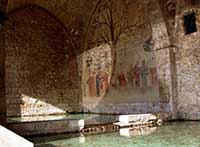
| Massa Marittima, Fonti dell’Abbondanza |
|
Balestro Girifalco |
|
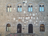
Massa Marittima
|

|
Biancane in Monterotondo Marittima [3]
|
Parco Geotermico delle Biancane: Geothermal Maremma | ‘Le Biancane’ Nature Park
|
The ‘Biancane’ area is extraordinary due to the vapor emissions that rise from the ground; these gases have distinctly modified its natural habitat and produced stunning colors throughout the Metallifere Hills. ‘Le Biancane’ Nature Park takes its name from ‘Le Biancane’ located a few hundred meters west of the historical center of Monterotondo Marittimo. The name biancane comes from the white colour of the rocks that characterizes the entire landscape: the hydrogen sulphide emissions, in fact, erupt from geysers in the ground and turn the limestone into gypsum.The park can be visited free of charge year-round.
More info in the tourist centre in Via del Poggiarello and on the park’s official website (in Italian).
|
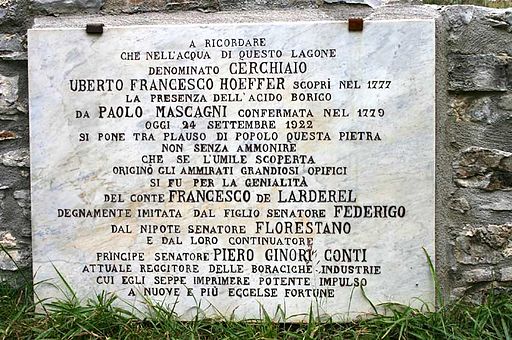
Plaque in memory of Uberto Francesco Hoefer

|
|
"A ricordare che nell'acqua di questo lagone denominato Cerchiaio, Uberto Francesco Hoeffer scopri nel 1777 la presenza dell Acido borico, da Paolo Mascagni confermata nel 1779. Oggi 24 settembre 1922, si pone tra plauso di popolo questa pietra, non senza ammonire che se l'umile scoperta origino gli ammirati grandiosi opifici, si fu per la genialità del conte Francesco de Larderel, degnamente imitata del figlio senatore Federigo, dal nipote senatore Florestano e dal loro continuatore principe senatore Piero Ginori Conti, attuale reggitore delle boraciche industrie cui egli seppe imprimere potente impulso a nuove e più eccelse fortune."
François Larderel, a young Frenchman having come to Tuscany in the early 19th century, discovers a hidden treasure: Boric Acid. He devotes his life to design a method to extract this mineral from the stemma-larderel.jpgvapours of the earth and then buids a small industrial empire around the production of Boron products. His descendants develop the business to a higher scale and turn it, in the early 20th Century, into a renewable energy industry that still thrives today in the Metalliferous Hills. [4]
Francesco De Larderel created a guide line for a new social and economic reality the "Regime Boracifera" of Tuscany.
In 1826 Francesco Larderel creates a new company – this time in his name only – that with high yields, low production costs and high quality year after year progresses contributing not only to the personal enrichment of the Larderel family, but also to that of Tuscany. In a relatively short time, around the main factory which the Granduca of Tuscany Leopold II, in recognition of the work carried out by Francesco Larderel named Larderello, new factories of smaller size were born in Castelnuovo di Val di Cecina, Sasso Pisano, Serrazzano, Lustignano, Lago Boracifero and Monterotondo. [4]
|
François Larderel
|
|
|
 |
Monterotondo Marittimo, Le Biancane
|

The Cornia valley is the ideal place for lovers of trekking and mountain bikes. The whole territory is rich in trekking routes passing through archaeology and nature, to journey through the Mediterranean scrub around the hillside councils of Suvereto, Sassetta and Campiglia Marittima, and those on the coast – Piombino and San Vincenzo.
Parco Naturale di Montioni
Address: Strada provinciale per Montioni
Telefone: 0565 226445 Fax: 0565 226521
Montioni: a wood covering more than 17,000 acres on the borders of the provinces of Livorno and Grosseto, where the visitor may adventure along countless pathways once home to woodcutters, charcoal burners, shepherds and huntsmen.
Download the map of the trials inl Parco di Montioni (Suvereto, Piombino, Follonica)
www.valdicorniaturismo.it
Sport e svaghi - Trekking - Costa degli Etruschi | Parco naturale di Montioni | Scarica la mappa
Point of departure and arrival: Montioni
Distance: 12 km approx
Duration: 4 hours on foot, 2 hours by mountain bike
Type of road: cart tracks and paths
Elevation gain: 320 metres approx
Difficulty: moderate
NOTE: The departure point is reached from provincial road No. 19 that connects Suvereto with Follonica. The route is ring-shaped with a branch off to the Pievaccia ruins. The itinerary can also be done by mountain bike: it does not present any technical difficulties apart from some stretches of path or road where the earth has been churned by wild boar, or with stones or exposed roots. [5]

In bicicletta - Costa degli Etruschi | www.costadeglietruschi.it | Percorsi cicloturistici
Cycling in Tuscany | Cycling tours in Southern Tuscany
www.turismoinmaremma.it | Colline Metallifere | Reiseführer und interessante Informationen über das Eisenerzgebiet | pdf Download
Sito ufficiale di Musei di Maremma.
Sito ufficiale della Cooperativa Colline Metallifere.
Parco Tecnologico Archeologico delle Colline Metallifere Grossetane, parcocollinemetallifere.it.
Trekking in Tuscany | Trekking in the Montioni Park, Etruscan Coast
Trekking in Tuscany | Trekking in Montioni Park | pdf
Trekking in Toscana | Itinerari e sentieri nel parco naturale di Montioni
Nature reserve Poggio Tre Cancelli
Part of the Interprovincial Park of Montioni, the Nature Reserve of Poggio Tre Cancelli was set upin 1971 and extends for 99 hectares, 50 of which form the reserve itself, the remaining 49 making up a protective contour.
|

[1] Source: Cicloturismo Toscana | www. maremmabike.it
[2] Pubblico dominio, https://it.wikipedia.org/w/index.php?curid=814504
[3] Photo byLigaDue, licenziato in base ai termini della licenza Creative Commons Attribuzione 3.0 Unported
[4] Source: The Larderel Family and Geothermal Energy | www.vecchienna.com
[5] Over 20% of the Costa degli Etruschi comprises Parks, protected areas, nature oases, and fauna reserves. Nature is not just a setting, but the very essence of this land with its dense stands of pine trees, woods and countryside rich with colours and scents.
Of particular note are the Bolgheri WWF Oasis, a wet zone of international importance, the Magona Park and its biogenetic oasis, the Livorno Hills Park, which is of considerable historical-naturalistic interest, the Rimigliano Park flora and fauna oasis, the Orti-Bottagone oasis and the Sterpaia and Montioni parks.
Source: www.costadeglietruschi.it. Copyright Provincia di Livorno Livorno.
|
Questo articolo è basato sugli articoli Monterotondo Marittimo e Parco naturalistico delle Biancane dell' enciclopedia Wikipedia ed è rilasciato sotto i termini della GNU Free Documentation License.
Wikimedia Commons contiene file multimediali su Monterotondo Marittimo.
|
|
|


